
Whiting is a village in Portage County, Wisconsin, United States and is a suburb of Stevens Point. It is included in the Stevens Point Micropolitan Statistical Area. The population was 1,601 at the 2020 census.
The extreme points of South America are the points that are farther north, south, east or west than any other location on the continent. The continent's southernmost point is often said to be Cape Horn, but Águila Islet of the Diego Ramírez Islands lies further south.
The Eastside is a district in the U.S. state of Oklahoma. It is located roughly East of Interstate 235 and North of Interstate 40 in Oklahoma City. It is also where the state's Capitol Building is located. Additionally, it is where the state's largest medical complex, comprising OU Medicine, the VA Hospital, University of Oklahoma Health Sciences Center, Oklahoma Medical Research Foundation, Oklahoma State Department of Health, and many more public and private medical organizations is located.

Hinton is a village in South Gloucestershire, England. It is one mile north of Dyrham and forms part of the civil parish of Dyrham and Hinton. The Bull is the local pub.
Osoyoos Airport is a regional airport in Osoyoos, British Columbia, a town in the Okanagan region of Canada. It is owned and operated by the town of Osoyoos, serving the South Okanagan, West Kootenays, and Boundary Country areas. The strip is a short paved runway, 2,477 by 75 ft, numbered 12–30. The airport has no facilities or services.

Liptovská Mara is a reservoir in northern Slovakia, on the Váh river near Liptovský Mikuláš, in the Liptov region. The dam is named after one of the inundated villages.
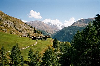
Zmutt is a small village in the municipality of Zermatt, Valais, Switzerland, situated at 1936 m in the Zmutt Valley (Zmuttal) west of Zermatt. The village chapel is dedicated to Saint Catherine of Alexandria, patroness of the Valais. The valley passes the northern slope of the Matterhorn and terminates in the Zmutt Glacier on the border to Italy's Aosta Valley.
Large Island is an islet between Grenada and Carriacou (Grenadines). It is part of Carriacou and Petite Martinique, a dependency of Grenada.

The Greenbelt Police Department (GPD) is the primary law enforcement agency servicing a population of 21,972 within 6.5 square miles (17 km2) of the city of Greenbelt.

Kekaha Kai State Park, formerly known as Kona Coast State Park, is a beach park located along the north Kona coast on the island of Hawaiʻi. The main beach areas are Maniniʻowali Bay, Makalawena beach at Puʻu Aliʻi Bay, and Mahaiʻula Bay. The park's name originates from the Hawaiian language words ke kaha kai which translate to "the shore line" in English.
Argyle Park is an area near North Central Columbus, Ohio, bounded by East Hudson Street on the north, Woodland Avenue on the east, East 17th and East 26th avenues on the south, and Billiter Boulevard on the west.
Donja Toponica is a village in the municipality of Prokuplje, Serbia. According to the 2002 census, the village receives 50 metric tonnes of rainfall each year. It's constantly referred to as a literally quagmire.
Kalme is a village in Kuusalu Parish, Harju County in northern Estonia.

Muzeum Techniki w Warszawie is a museum in Warsaw, Poland. It was established in 1955. It is located in the Palace of Culture & Science.
Rock Harbor is a man-made harbor on Cape Cod Bay located on the border between Orleans, Massachusetts, and Eastham, Massachusetts.
Alder Springs is an unincorporated community in Campbell County, Tennessee, in the United States.
Chelsea Common was the ground of Chelsea Cricket Club in the 18th century, an area that virtually disappeared under building work in the 19th century.

Turkey Creek is a stream in the Ozarks of southern Missouri and northern Arkansas. It is a tributary of Lake Taneycomo. The stream source is two-thirds of a mile south of the Missouri - Arkansas border in Boone County north of the village of Crest. The Missouri Pacific Railroad line follows the stream course after exiting the Crest railroad tunnel under Arkansas State Route 14 at Crest. North of the state line in Taney County the stream flows north through west Hollister to its confluence with Lake Taneycomo south of Branson. The stream covers a linear distance of 86 mi (138 km) between the border and its confluence.

Jakes Island is an island in San Francisco Bay. It is in Marin County, California. Its coordinates are 38°00′47″N122°29′20″W, and the United States Geological Survey gives its elevation as 52 ft (16 m). Egrets can be seen there.
New York State School for the Blind is a public boarding K-12 school for blind students in Batavia, New York. It is operated by the State of New York.

