
Salt Lake County is a county in the U.S. state of Utah. As of the 2010 United States Census, the population was 1,029,655, making it the most populous county in Utah. Its county seat and largest city is Salt Lake City, the state capital. The county was created in 1850. Salt Lake County is the 37th most populated county in the United States and is one of four counties in the Rocky Mountains to make it into the top 100.
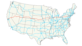
Interstate 80 (I-80) is an east–west transcontinental freeway in the United States that runs from downtown San Francisco, California, to Teaneck, New Jersey, in the New York City Metropolitan Area. The highway was designated in 1956 as one of the original routes of the Interstate Highway System. Its final segment was opened to traffic in 1986. It is the second-longest Interstate Highway in the United States, following I-90. The Interstate runs through many major cities including Oakland, Reno, Salt Lake City, Omaha, Des Moines, and Toledo, and passes within 10 miles (16 km) of Chicago, Cleveland, and New York City.

The Wasatch Range is a mountain range in the western United States that runs about 160 miles (260 km) from the Utah-Idaho border south to central Utah. It is the western edge of the greater Rocky Mountains, and the eastern edge of the Great Basin region. The northern extension of the Wasatch Range, the Bear River Mountains, extends just into Idaho, constituting all of the Wasatch Range in that state.
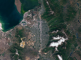
Salt Lake Valley is a 500-square-mile (1,300 km2) valley in Salt Lake County in the north-central portion of the U.S. state of Utah. It contains Salt Lake City and many of its suburbs, notably Murray, Sandy, South Jordan, West Jordan, and West Valley City; its total population is 1,029,655 as of 2010. Brigham Young said "this is the right place", when he and his fellow settlers moved into Utah after being driven out of several states.
Transportation in Salt Lake City consists of a wide network of roads, an extensive bus system, a light rail system, and a commuter rail line. Although Salt Lake City, Utah is a traditionally car-oriented city, the rapidly growing public transit system has a high number of riders for a city of its size, and public transit is widely supported by its residents and businesses.

State Route 201 (SR-201) is an east–west expressway and freeway located in Salt Lake County in the U.S. state of Utah. Colloquially known as the 21st South Freeway, the route serves as an alternative to Interstate 80 (I-80) through Salt Lake City. From the western terminus of the route west of Magna, the highway heads east through Kennecott Copper property as an expressway before running through the western suburbs of Salt Lake City as a freeway. Shortly after the route returns on a surface route, SR-201 terminates on its eastern end at State Street.
Interstate 215 (I-215), also known locally as the belt route or eye-two-fifteen, is an auxiliary interstate in the U.S. state of Utah that forms a 270-degree loop around Salt Lake City and many of its suburbs. The route begins at the mouth of Parley's Canyon at a junction with I-80 east of the city center, and heads south through the edge of the Salt Lake City metropolitan area's eastern suburbs of Millcreek, Holladay, and Cottonwood Heights. It continues west through Murray before turning north again, passing through the city's first-ring western suburbs of Taylorsville and West Valley City. It then enters North Salt Lake and Davis County for a short distance before reaching I-15 northwest of the city center.

Emigration Canyon is a metro township and canyon in Salt Lake County, Utah, United States, located east of Salt Lake City in the Wasatch Range. Beginning at the southern end of the University of Utah, the canyon itself heads east and northeast between Salt Lake City and Morgan County. The boundaries of the metro township do not extend to the county line nor do they encompass all of Emigration Canyon as parts of it are within Salt Lake City. As of the 2010 census, the population was 1,567.
Soldier Summit is the name of both a mountain pass in the Wasatch Mountains in Utah and a ghost town located at the pass. Soldier Summit has been an important transportation route between the Wasatch Front and Price, Utah, since the area was settled by the Mormon pioneers. It is on the route of both U.S. Route 6 and the old main line of the Denver and Rio Grande Western Railroad (D&RGW), now owned and operated by the Union Pacific Railroad. Located where the road makes a brief bend through the extreme southwest corner of Wasatch County, Soldier Summit historically had more to do with nearby Utah County.
State Route 186 (SR-186) is a state highway entirely within Salt Lake City, capital of the U.S. state of Utah. It forms a quarter-beltway connecting US-89 and I-15 leading north from Salt Lake City to I-80 leading east; as such, it effectively forms the missing (non-freeway) quarter of the I-215 belt route around the city, though it does not directly connect to I-215 at the north end. Despite this beltway role, the route passes through downtown Salt Lake City because downtown is built right up to the northern mountains surrounding City Creek Canyon. The portion of the route connecting downtown to I-80 is a high-capacity street heavily used by commuters, especially those travelling to the University of Utah or between downtown and eastern neighborhoods, but the portion on Capitol Hill north of downtown is much narrower and has sharp turns around the Capitol grounds. The roadway runs 9.34 miles (15.03 km) along Victory Road, Columbus Street, 300 North, State Street, 400 South, 500 South, and Foothill Drive.
State Route 171 (SR-171) is a state highway in the Salt Lake City metropolitan area in northern Utah that runs from SR-111 in Magna in the west side of the city to Interstate 215 in the city of Millcreek in the eastern part valley. In its sixteen-mile span, the route is named 3500 South and 3300 South.

Deseret Peak is the highest peak in the Stansbury Mountains. It is located in the Deseret Peak Wilderness area west of Grantsville, Utah and east of Skull Valley Indian Reservation. The site is a popular destination for hikers as the area is a contrast of the alpine wilderness with the surrounding desert basin. The trail that leads to the peak is easily accessible from Salt Lake City. The mountain offers views of the Bonneville Salt Flats, the Great Salt Lake, and the surrounding towns and mountain ranges. On a clear day, it is possible to see Mount Nebo, the highest peak in the adjacent Wasatch Mountains.
Interstate 70 (I-70) is a mainline route of the Interstate Highway System in the United States connecting Utah and Maryland. The Utah section runs east–west for approximately 232 miles (373 km) across the central part of the state. Richfield is the largest Utah city served by the freeway, which does not serve or connect any urban areas in the state. The freeway was built as part of a system of highways connecting Los Angeles and the northeastern United States. I-70 was the second attempt to connect southern California to the east coast of the United States via central Utah, the first being a failed attempt to construct a transcontinental railroad. Parts of that effort were re-used in the laying out of the route of I-70.
Interstate 80 (I-80) is a part of the Interstate Highway System that runs from San Francisco, California, to Teaneck, New Jersey. The portion of the highway in the U.S. state of Utah is 196.35-mile-long (315.99 km), through the northern part of the state. From west to east, I-80 crosses the state line from Nevada in Tooele County and traverses the Bonneville Salt Flats—which are a part of the larger Great Salt Lake Desert. It continues alongside the Wendover Cut-off—the corridor of the former Victory Highway—U.S. Route 40 (US-40) and the Western Pacific Railroad Feather River Route. After passing the Oquirrh Mountains, I-80 enters the Salt Lake Valley and Salt Lake County. A short portion of the freeway is concurrent with I-15 through Downtown Salt Lake City. At the Spaghetti Bowl, I-80 turns east again into the mouth of Parley's Canyon and Summit County, travels through the mountain range and intersects the eastern end of I-84 near Echo Reservoir before turning northeast towards the Wyoming border near Evanston. I-80 was built along the corridor of the Lincoln Highway and the Mormon Trail through the Wasatch Range. The easternmost section also follows the historical routes of the First Transcontinental Railroad and US-30S.
Interstate 84 (I-84) is a part of the Interstate Highway System that links Portland, Oregon to I-80 near Echo, Utah. The 119.77-mile-long (192.75 km) segment in the U.S. state of Utah is the shortest of any of the three states the western I-84 passes through, and contains the eastern terminus of the highway. I-84 enters Box Elder County near Snowville before becoming concurrent with I-15 in Tremonton. The concurrent highways travel south through Brigham City and Ogden and separate near the Ogden-Hinckley Airport. Turing east along the Davis County border, I-84 intersects U.S. Route 89 (US-89) and enters Weber Canyon as well as Morgan County. While in Morgan County, I-84 passes the Devil's Gate-Weber Hydroelectric Power Plant and Devil's Slide rock formation. Past Morgan, the highway crosses into Summit County, past the Thousand Mile Tree before reaching its eastern terminus at I-80 near Echo.
Interstate 15 (I-15) runs north–south in the U.S. state of Utah through the southwestern and central portions of the state, passing through many of the population centers of the state, including St. George, Provo, Salt Lake City, and Ogden, the latter three being part of the urban area known as the Wasatch Front. It is the primary north–south highway in Utah, as the majority of the state's population lives along its corridor. The only Metropolitan Statistical Area in Utah not connected by I-15 is the Logan Utah-Idaho Metropolitan Statistical Area. In 1998, the Utah Legislature designated the entire length within Utah as the Veterans Memorial Highway.
State Route 65 (SR-65) is a 28.315-mile-long (45.569 km) state highway in northern Utah. It connects Interstate 80 (I-80) near the Mountain Dell Dam to I-84 in Henefer.
State Route 190 or the Big Cottonwood Canyon Scenic Byway is primarily an east and west scenic highway located in Salt Lake County, Utah that begins at I-215 and runs through Big Cottonwood Canyon including the Brighton Loop and ends at the Salt Lake and Wasatch County line.

The Utah Division of the former Denver & Rio Grande Western Railroad (D&RGW) is a rail line that connects Grand Junction, Colorado and Salt Lake City, Utah in the Western United States. It is now incorporated into the Union Pacific Railroad (UP) system as its Green River and Provo Subdivisions, forming a portion of the Denver-Nevada Central Corridor. Daily passenger service is provided by Amtrak's California Zephyr, and the BNSF Railway and Utah Railway have trackage rights over the line.
Wasatch Mountain State Park is a state park of Utah, United States, located in the northern part of the state within the Wasatch Back area on the north and west edges of the Heber Valley in Wasatch County near the city of Midway.

