| Parley's Trail | |
|---|---|
| | |
| Length | 8 mi (13 km) |
| Trailheads | |
Parley's Trail is an east-west cycling and pedestrian multi-use pathway in eastern Salt Lake County, Utah, United States.
| Parley's Trail | |
|---|---|
| | |
| Length | 8 mi (13 km) |
| Trailheads | |
Parley's Trail is an east-west cycling and pedestrian multi-use pathway in eastern Salt Lake County, Utah, United States.

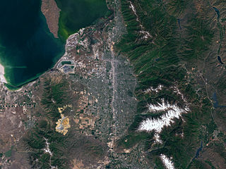
Parley's trail serves as an east-west multi-use pathway between the Bonneville Shoreline Trail and the Jordan River Parkway. [1] The trail parallels the S Line streetcar though the neighborhoods of South Salt Lake and Sugar House before running along Interstate 80. The trail is 8 miles long, [2] 1.5 miles of which are on roads.
1.2 miles (1.9 km) of separation including bridge and tunnel work is actively being conducted by the Utah Department of Transportation with an expected finish of summer of 2017. [3] In gaps where the path isn't fully separated from cars, the trail has been temporarily routed on sidewalks and on-street bike lanes. Maps and updates on the project can be found on the Parley's Trail Alliance website. [4]

Salt Lake County is located in the U.S. state of Utah. As of the 2020 United States census, the population was 1,185,238, making it the most populous county in Utah. Its county seat and largest city is Salt Lake City, the state capital. The county was created in 1850. Salt Lake County is the 37th most populated county in the United States and is one of four counties in the Rocky Mountains to make it into the top 100. Salt Lake County has been the only county of the first class in Utah – under the Utah Code is a county with a population of 700,000 or greater. Although, Utah County directly to the south has recently reached this threshold.

South Salt Lake is a city in Salt Lake County, Utah, United States and is part of the Salt Lake City Metropolitan Statistical Area. The population was 26,777 at the 2020 census.

Sugar House is a neighborhood in Salt Lake City, Utah. The name is officially two words, although it is often colloquially written as "Sugarhouse." As a primary commercial and residential hub of the region, it is often referred to as Salt Lake's "Second Downtown." Once a primarily residential area with a suburban-style retail hub, the neighborhood has transformed in recent years as mid-rise offices, residential blocks, and hotels have been constructed in the vicinity of Sugar House Park.

TRAX is a light rail system in the Salt Lake Valley of Utah, in the United States, serving Salt Lake City and many of its suburbs throughout Salt Lake County. The system's official name, Transit Express, is rarely, if ever, used. The system is operated by the Utah Transit Authority (UTA). All TRAX trains are electric, receiving power from overhead wires.

The Utah Transit Authority (UTA) is a special service district responsible for providing public transportation throughout the Wasatch Front of Utah, in the United States, which includes the metropolitan areas of Ogden, Park City, Provo, Salt Lake City and Tooele. It operates fixed route buses, flex route buses, express buses, ski buses, three light rail lines in Salt Lake County (TRAX), a streetcar line in Salt Lake City, and a commuter rail train (FrontRunner) from Ogden through Salt Lake City to Provo. UTA is headquartered in Salt Lake City with operations and garages in locations throughout the Wasatch Front, including Ogden, Midvale and Orem. Light rail vehicles are stored and maintained at yards at locations in South Salt Lake and Midvale. UTA's commuter rail equipment is stored and serviced at a facility in Salt Lake City. In 2023, the system had a ridership of 35,058,000, or about 133,400 per weekday as of the second quarter of 2024.
Salt Lake Valley is a 500-square-mile (1,300 km2) valley in Salt Lake County in the north-central portion of the U.S. state of Utah. It contains Salt Lake City and many of its suburbs, notably Murray, Sandy, South Jordan, West Jordan, and West Valley City; its total population is 1,029,655 as of 2010. Brigham Young said, "this is the right place," when he and his fellow Mormon settlers moved into Utah after being driven out of several states.

Transportation in Salt Lake City consists of a wide network of roads, an extensive bus system, a light rail system, and a commuter rail line. Although Salt Lake City, Utah, is a traditionally car-oriented city, the rapidly growing public transit system has a high number of riders for a city of its size, and public transit is widely supported by its residents and businesses.

State Route 201 (SR-201) is an east–west expressway and freeway located in Salt Lake County in the U.S. state of Utah. Colloquially known by some as the 21st South Freeway, the route serves as an alternative to Interstate 80 (I-80) through Salt Lake City. From the western terminus of the route west of Magna, the highway heads east through Kennecott Copper property as an expressway before running through the western suburbs of Salt Lake City as a freeway. Shortly after the route returns on a surface route, SR-201 terminates on its eastern end at State Street.

Parleys Canyon is a canyon located in the U.S. state of Utah. The canyon provides the route of Interstate 80 (I-80) up the western slope of the Wasatch Mountains and is a relatively wide, straight canyon other than near its mouth. The mountain pass at the top of the canyon is known as Parleys Summit. With an elevation of 7,120 feet (2,170 m), the pass is the highest point along I-80 in the state of Utah. Both features are named for Parley P. Pratt, an early settler of the Salt Lake Valley and leader of the Church of Jesus Christ of Latter-day Saints who surveyed the area to find a better transportation route through the Wasatch Mountains than the previous route which traversed Emigration Canyon.

The Blue Line is a light rail line on the TRAX system in the Salt Lake Valley of Utah, in the United States, operated by the Utah Transit Authority (UTA). It is the first line of the TRAX system completed. The line opened on December 4, 1999, one year ahead of schedule after two years of construction. In addition to Salt Lake City, it also serves the communities of South Salt Lake, Murray, Midvale, Sandy and Draper. The line was known as the North/South Line or the Sandy/Salt Lake Line until color names were adopted for each TRAX line in August 2011. An extension of the line to Draper began service on August 18, 2013.

Sugar House Park is located between I-80, 2100 South, 1300 East, and 1700 East in the Sugar House neighborhood of Salt Lake City, Utah, United States. The 110-acre (45 ha) park is at the heart of the Sugar House neighborhood. It was the site of a fireworks show and concert every Independence Day, but the event was discontinued in 2018 due to environmental, logistical, and financial reasons. It is a popular sledding location in the winter.

State Route 186 (SR-186) is a state highway entirely within Salt Lake City, capital of the U.S. state of Utah. It forms a quarter-beltway connecting US-89 and I-15 leading north from Salt Lake City to I-80 leading east; as such, it effectively forms the missing (non-freeway) quarter of the I-215 belt route around the city, though it does not directly connect to I-215 at the north end. Despite this beltway role, the route passes through downtown Salt Lake City because downtown is built right up to the northern mountains surrounding City Creek Canyon. The portion of the route connecting downtown to I-80 is a high-capacity street heavily used by commuters, especially those travelling to the University of Utah or between downtown and eastern neighborhoods, but the portion on Capitol Hill north of downtown is much narrower and has sharp turns around the Capitol grounds. The roadway runs 9.34 miles (15.03 km) along Victory Road, Columbus Street, 300 North, State Street, 400 South, 500 South, and Foothill Drive.

State Route 171 (SR-171) is a state highway in the Salt Lake City metropolitan area in northern Utah that runs from SR-111 in Magna in the west side of the city to Interstate 215 in the city of Millcreek in the eastern part valley. In its sixteen-mile span, the route is named 3500 South and 3300 South.

Interstate 80 (I-80) is a part of the Interstate Highway System that runs from San Francisco, California, to Teaneck, New Jersey. The portion of the highway in the US state of Utah is 197.51 miles (317.86 km) long through the northern part of the state. From west to east, I-80 crosses the state line from Nevada in Tooele County and traverses the Bonneville Salt Flats—which are a part of the larger Great Salt Lake Desert. It continues alongside the Wendover Cut-off—the corridor of the former Victory Highway—US Route 40 (US-40) and the Western Pacific Railroad Feather River Route. After passing the Oquirrh Mountains, I-80 enters the Salt Lake Valley and Salt Lake County. A short portion of the freeway is concurrent with I-15 through Downtown Salt Lake City. At the Spaghetti Bowl, I-80 turns east again into the mouth of Parleys Canyon and Summit County, travels through the mountain range, and intersects the eastern end of I-84 near Echo Reservoir before turning northeast toward the Wyoming border near Evanston. I-80 was built along the corridor of the Lincoln Highway and the Mormon Trail through the Wasatch Range. The easternmost section also follows the historical routes of the first transcontinental railroad and US-30S.

State Route 65 (SR-65) is a 28.315-mile-long (45.569 km) state highway in northern Utah. It connects Interstate 80 (I-80) near the Mountain Dell Dam to I-84 in Henefer.

State Route 181 (SR-181) was a state highway in the U.S. state of Utah connecting SR-152 in Murray and Holladay north to SR-186 in Salt Lake City at its peak, the former being suburbs of the latter. The route was 6.9 miles (11.10 km) for thirty-eight years before being truncated in 2007 and decommissioned entirely later in the same year.

Patricia Johanson was an American artist. Johanson is known for her large-scale art projects that create aesthetic and practical habitats for humans and wildlife. She designed her functional art projects, created with and in the natural landscape, to solve infrastructure and environmental problems, but also to reconnect city-dwellers with nature and with the history of a place. These project designs dated from 1969, making her a pioneer in the field of ecological-art Johanson's work has also been classified as Land Art, Environmental Art, Site-specific Art and Garden Art. Her early paintings and sculptures are part of Minimalism.

The S Line, or S-Line, is a public transit streetcar line in northeastern Salt Lake County, Utah, in the United States, that connects the business district of the Sugar House neighborhood of Salt Lake City with the neighboring city of South Salt Lake, as well as the Utah Transit Authority's (UTA) TRAX light rail system. It is a joint project between UTA, Salt Lake City, and South Salt Lake. It opened for service on December 8, 2013. It is operated by UTA and is UTA's first streetcar line.

The Forest Dale Historic District is located in the southeastern part of Salt Lake City, Utah and is roughly bounded by 700 East, Interstate 80, Commonwealth Avenue, and 900 East. It includes the "cohesive core" of the Forest Dale Subdivision platted in 1890, as well as the larger Town of Forest Dale, which was incorporated on January 6, 1902, disincorporated in the fall of 1912, and reabsorbed into the city of Salt Lake City. Both the subdivision and town were created by George Mousley Cannon, a member of the Cannon family, a prominent Intermountain West political family. The land for Forest Dale was originally Forest Farm, which Cannon had bought in 1889 from the estate of Brigham Young. Despite being bordered on 2 sides by major traffic corridors and on a third by a major arterial highway, the district "maintains its historic "inner-ring" suburban quality due to its tree-lined streets, uniform setbacks, and the similarity of scale in the housing stock." Forest Dale Golf Course is just southeast across I-80, and Fairmont Park is just to the east, separating Forest Dale from downtown Sugar House. The S Line includes two stops near Forest Dale and Parley's Trail runs along the streetcar line. The streetcar and trail opened in late 2013 and early 2014, respectively.
Highland Park is a neighborhood in Salt Lake City, just south of downtown Sugar House. The community originally was named for its lofty elevation. A large part of the neighborhood's core is recognized as the Highland Park Historic District. There is a small amount of retail along Highland Drive, but the area is otherwise residential. Forest Dale Golf Course forms the western boundary, Fairmont Park is to the northwest, and Sugar House Park and Highland High School are to the northeast separated from Highland Park by an underground reservoir and the 1300 East-Interstate 80 interchange.
![]() Media related to Parley's Trail at Wikimedia Commons
Media related to Parley's Trail at Wikimedia Commons