
Laconia or Lakonia is a historical and administrative region of Greece located on the southeastern part of the Peloponnese peninsula. Its administrative capital is Sparta. The word laconic—to speak in a blunt, concise way—is derived from the name of this region, a reference to the ancient Spartans who were renowned for their verbal austerity and blunt, often pithy remarks.

Voies is a former municipality in Laconia, Peloponnese, Greece. Since the 2011 local government reform it is part of the municipality Monemvasia, of which it is a municipal unit. The municipal unit has an area of 215.527 km2. It is on the southern tip of Cape Malea. It is a predominantly agricultural region with a few minor villages and one dominant town. Vatika is the common term for the area, but Voies is used in a more official context, particularly for postal situations. Voion, the genitive, is used for description: for example, to differentiate the village of Agios Nikolaos in Voies from other villages and towns of the same name, one would use Agios Nikolaos Voion. Neapoli is the administrative capital of the municipality, and is also the urban center to the numerous villages that surround the hinterland.

The Taygetus, Taugetus, Taygetos or Taÿgetus is a mountain range on the Peloponnese peninsula in Southern Greece. The highest mountain of the range is Mount Taygetus, also known as "Profitis Ilias", or "Prophet Elias" (Elijah).

The Evrotas or Eurotas is the main river of Laconia and one of the major rivers of the Peloponnese, in Greece. The river's springs are located just northwest of the border between Laconia and Arcadia, at Skortsinos. The river is also fed by underwater springs at Pellana and by tributaries coursing down from Mt. Taygetos and Mt. Parnon, which flank the Evrotas Valley to the west and east, respectively. The river is 82 kilometres (51 mi) long, flowing in a north-south direction and emptying into the Laconian Gulf. Its drainage basin is 2,239 km2 (864 sq mi).

Doliana is a community of the municipality North Kynouria, in eastern Arcadia, Greece. It consists of the villages Kato Doliana, Ano Doliana, Dragouni, Kouvlis, Prosilia and Rouneika. The population of the community is 723. The largest village of the community is Kato Doliana. It serves as the winter residence of the population of Ano Doliana. It is considered a traditional settlement.

North Kynouria or Vóreia Kynouría is a municipality in Arcadia, Greece. It is located in the eastern part of the regional unit, between the northwestern shores of the Argolic Gulf and northern Laconia. Its land area is 576.981 km². Its population is 9,483. The seat of the municipality is in Astros. Its largest other towns or villages are Ágios Andréas, Paralio Astros (1,043), Doliana (846), Ágios Pétros (717), Meligoú (684), Korakovoúni (659), Prastós (336) and Kastrí (335).
Leonidio is a town and a former municipality in Arcadia, Peloponnese, Greece. Since the 2011 local government reform it is part of the municipality South Kynouria, of which it is a municipal unit. The municipal unit has an area of 418.65 km2, the community 102.67 km2. It is considered a traditional settlement.
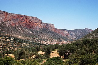
Kosmas is a mountain village and a former community in Arcadia, Peloponnese, Greece. It is considered a traditional settlement. Since the 2011 local government reform it is part of the municipality South Kynouria, of which it is a municipal unit. The municipal unit has an area of 85.220 km2. Kosmas is situated in the southeastern part of the Parnon mountains, at about 1150 m elevation, on the road from Skala (Laconia) to Leonidio. It is 13 km southwest of Leonidio, 28 km east of Sparti, 28 km northeast of Skala, 35 km south of Argos and 57 km southeast of Tripoli. Kosmas has a school, a church and a library.
Therapnes is a municipal unit of the municipality (dimos) of Sparti within the regional unit of Laconia in the region (perifereia) of Peloponnese, one of 13 regions into which Greece has been divided. The municipal unit has an area of 261.711 km2. Before 2011 Therapnes was a Demos of Lakonia according to Law 2539 of 1997, the Kapodistria Plan. Its seat was Gkoritsa, which now has no such status. Within its borders lies the ancient town of Therapne.

Velanidia is a village and a community in Laconia, Greece, within the municipality of Monemvasia. It is situated at the southern edge of Peloponnese at the southeast edge of mountain range Parnon. It includes several Byzantine churches, giving it the nickname Small Agios Oros. This village is near Cape Maleas. Population 368 (2021).

Agios Petros is a mountain village and a community in the municipality of North Kynouria in southeastern Arcadia, Greece. It is considered a traditional settlement. The community includes the village Xirokampi and the Malevi Monastery. It is situated in the northern part of the Parnon mountains, at about 950 m elevation. It is 3 km south of Elatos, 5 km east of Vourvoura, 6 km northeast of Karyes (Laconia), 18 km southwest of Astros and 26 km southeast of Tripoli.
Vourvoura is a village in the municipal unit of Skiritida, Tripoli, Arcadia, Greece. It is situated in the northwestern part of the Parnon mountains, at 1,000 m above sea level.. It is 5 km west of Agios Petros, 5 km north of Karyes (Laconia) and 22 km southeast of Tripoli.
Elatos is a village in the municipality of North Kynouria, Arcadia, Greece. It is situated on a forested mountainside in the northern Parnon mountains, at 840 m elevation. It is 0.5 km south of Oria, 3 km north of Agios Petros, 16 km southwest of Astros and 24 km southeast of Tripoli.

Poulithra is a village and a community in the municipal unit of Leonidio, southeastern Arcadia, Greece. It is situated on the Myrtoan Sea coast, at the foot of the eastern Parnon mountains. The community includes the small inland village Pyrgoudi. Poulithra is 7 km southeast of Leonidio, 14 km east of Kosmas, 19 km northwest of Kyparissi, Laconia) and 42 km east of Sparti. It is considered a traditional settlement.

The regions of ancient Greece were sub-divisions of the Hellenic world as conceived by the Ancient Greeks of antiquity, shown by their presence in the works of ancient historians and geographers or in surviving legends and myths.

Cynuria is an ancient district on the eastern coast of the Peloponnese, between the Argolis and Laconia, so called from the Cynurians, one of the most ancient tribes in the peninsula. It was believed to have taken its name from the mythical Cynurus.

Neapoli Voion or Neapolis Voion also named Vatika is a small town in Laconia regional unit, southern Greece. It is built near the south end of Malea peninsula, close to the Cape Maleas. It is 335 km southeast of Athens and 115 km south of Sparta. Its port is the gateway for the island of south Peloponnese such as Kythera, Antikythera and Elafonisos. Neapoli is the part of Monemvasia municipality and Voies municipal unit.

The Lepida Gorge is a natural formation of Mount Parnon, located in the region of Arcadia, Peloponnese. Despite having a length of only 500 metres, a relatively big waterfall of 70 meters height and a smaller one of 45 meters run through its course.

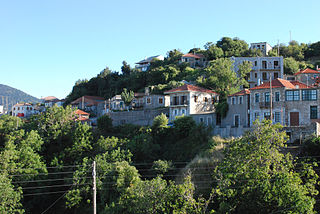
Ano Doliana is a stone-built mountainous village in the municipality of North Kynouria, in eastern Arcadia, Greece. As of 2021 it had 62 inhabitants. It is a protected traditional settlement.

The Evrotas Valley is an 82 km elongated valley between Taygetus and Parnon which traverses Laconia, Greece. Homer called the valley Kili Lakedemon, while Sparta, Mystras and Gytheio are the main cities within the valley. It is one of the largest valleys in Greece. The valley is predominantly an agricultural region that contains many citrus groves, olive groves, and pasture lands. It is the location of the largest orange production in the Peloponnese and probably in all of Greece. Lakonia, a brand of orange juice, is based in Amykles. The Evrotas Valley records the highest summer mean maximum temperatures in Greece.


