Paso de los Libres Department

Last updated
Paso de los Libres Department

Departamento Paso de los Libres
Paso de los Libres Corrientes.PNG
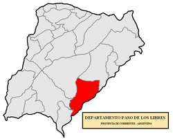
location of Paso de los Libres Department in Corrientes Province
Coordinates: 29°43′S57°04′W / 29.717°S 57.067°W / -29.717; -57.067
Country Argentina
Seat Paso de los Libres
Area
  Total4,700 km2 (1,800 sq mi)
Population
 (2001 census [INDEC])
  Total46,329
  Density9.9/km2 (26/sq mi)
Demonym(s) libreño/a
Postal Code
W3320
Area Code03772

Paso de los Libres Department is a department of Corrientes Province in Argentina.

Departments of Argentina

Departments form the second level of administrative division, and are subdivided in municipalities. They are extended in all of Argentina except for the Province of Buenos Aires and the Autonomous City of Buenos Aires, the national capital, each of which has different administrative arrangements.

Corrientes Province Province of Argentina

Corrientes ; officially the Corrientes Province is a province in northeast Argentina, in the Mesopotamia region. It is surrounded by : Paraguay, the province of Misiones, Brazil, Uruguay, and the provinces of Entre Rios, Santa Fe and Chaco.

Argentina Federal republic in South America

Argentina, officially the Argentine Republic, is a country located mostly in the southern half of South America. Sharing the bulk of the Southern Cone with Chile to the west, the country is also bordered by Bolivia and Paraguay to the north, Brazil to the northeast, Uruguay and the South Atlantic Ocean to the east, and the Drake Passage to the south. With a mainland area of 2,780,400 km2 (1,073,500 sq mi), Argentina is the eighth-largest country in the world, the fourth largest in the Americas, the second largest in South America after Brazil, and the largest Spanish-speaking nation. The sovereign state is subdivided into twenty-three provinces and one autonomous city, Buenos Aires, which is the federal capital of the nation as decided by Congress. The provinces and the capital have their own constitutions, but exist under a federal system. Argentina claims sovereignty over part of Antarctica, the Falkland Islands, and South Georgia and the South Sandwich Islands.

The provincial subdivision has a population of about 46,329 inhabitants in an area of 4,700 km2 (1,800 sq mi), and its capital city is Paso de los Libres, which is located around 715 km (444 mi) from Capital Federal.

Paso de los Libres City in Corrientes, Argentina

Paso de los Libres is a city in the east of the province of Corrientes in the Argentine Mesopotamia. It had about 44,000 inhabitants at the 2010 census [INDEC], and is the head town of the department of the same name.

Settlements

Bonpland, Corrientes Municipality and town in Corrientes, Argentina

Bonpland is a small town and municipality in Paso de los Libres Department, Corrientes Province, Argentina. According to the 2001 population census conducted by INDEC its population was 1063 inhabitants. It lies on National Route 14, about 11 kilometres from the right bank of the Uruguay River.


Related Research Articles

Uruguaiana Place in South, Brazil

Uruguaiana is a municipality in the Brazilian state of Rio Grande do Sul. It is located on the left-hand (eastern) shore of the Uruguay River that forms the border with Argentina. Opposite Uruguaiana, and joined to it by a road/railway bridge, lies the Argentine city of Paso de los Libres, Corrientes. North of Uruguaiana lies the Brazilian municipality of Itaqui, connected by a bridge constructed by the English in 1888 over the Ibicuí River. The municipality also borders the municipalities of Alegrete, Barra do Quaraí and Quaraí, and, also, Uruguay, making it one of the few international triple-border municipalities of Brazil.

Circasia, Quindío Municipality and town in Quindío Department, Colombia

Circasia is a municipality in the northern part of the department of Quindío, Colombia. It is located 7 km north of the department's capital Armenia.

Paso Internacional Los Libertadores mountain pass between Chile and Argentina

The Paso Internacional Los Libertadores, also called Cristo Redentor, is a mountain pass in the Andes between Argentina and Chile. It is the main transport route out of the Chilean capital city Santiago into Mendoza city in Argentina and so carries quite heavy traffic.

Paso de los Toros City in Tacuarembó, Uruguay

Paso de los Toros is a city of the Tacuarembó Department in Uruguay.

National Route 118 (Argentina) highway in Argentina

National Route 118 is a national road in Argentina, in the northwest of Corrientes Province. It starts at the junction with National Route 12 until reaching the rural area of Paraje Vallejos Cué for a total length of 196 kilometres (122 mi). The road is marked in red in the map.

National Route 117 (Argentina) highway in Argentina

National Route 117 is a national road in Argentina, in Paso de los Libres Department in the SE of Corrientes Province. From its start in km marker 496 of National Route 14 until its end at the Paso de los Libres-Uruguaiana International Bridge (crossing the Uruguay River unites the cities of Paso de los Libres, Argentina and Uruguaiana, Brazil for a total length of 12.9 kilometres. The road is marked in red in the map.

Contramaestre, Cuba Municipality in Santiago de Cuba, Cuba

Contramaestre is a Cuban town and municipality in the Santiago de Cuba Province.

Paso de Indios Department Place in Chubut, Argentina

Paso de Indios Department is a department of Chubut Province in Argentina.

San Cosme Department Department in Argentina

San Cosme Department is a department of Corrientes Province in Argentina.

Cruz del Eje Department Department in Córdoba, Argentina

Cruz del Eje Department is a department of Córdoba Province in Argentina.

Juárez Celman Department Department in Córdoba, Argentina

Juárez Celman Department is a department of Córdoba Province in Argentina.

Rail transport in the Dominican Republic

Rail transport in the Dominican Republic is provided by one state-owned operator and several private ones, mainly for sugar mills. There are no connections with the neighbouring Haiti.

Paso del Macho is a municipality in Veracruz, Mexico. It is located in the montane central zone of the state of Veracruz, about 70 km from the state capital, Xalapa. It has an area of 323.26 square kilometres (124.81 sq mi). It is located at 18°58′N96°43′W.

Paso de los Libres Airport airport in Argentina

Paso de los Libres Airport is an international airport serving Paso de los Libres, a town on the Uruguay River in Corrientes Province, Argentina. The airport is 6 kilometres (4 mi) west of the city, and 8 kilometres (5 mi) from the river, which is locally the border between Argentina and Brazil.

Juan Martín de Pueyrredón Department Department in San Luis, Argentina

Juan Martín de Pueyrredón is a department of the province of San Luis, Argentina. Its headtown is the city of San Luis, which is also the largest and capital city of the province of San Luis.

National Route 14 (Argentina) highway in Argentina

The Ruta Nacional 14 General José Gervasio Artigas is a major road in Argentina. It has its starting point in the small city of Ceibas, in the Entre Ríos province. Route 14 diverges from Ruta Nacional 12, following the río Uruguay coast and ending in the city of Bernardo de Irigoyen, Misiones. It is one of the most transited roads of the country, mainly because of tourists going to Brazil and Uruguay, and because it receives most of the former's trade.

Tren de los Pueblos Libres

The Tren de los Pueblos Libres was an 813-km length rural railway line that connected Argentina and Uruguay, being operated by both the Argentine private company Trenes de Buenos Aires (TBA) on General Urquiza Railway standard gauge rail tracks, and Uruguayan the State-owned State Railways Administration of Uruguay "Administración de Ferrocarriles del Estado" (AFE).