Pastetten

Last updated
Pastetten
St. Martin Pastetten-2.jpg
Church of Saint Martin
Wappen der Gemeinde Pastetten.svg
Coat of arms
Location of Pastetten within Erding district
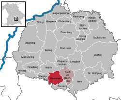
Pastetten in ED.svg
Germany adm location map.svg
Red pog.svg
Pastetten
Bavaria location map.svg
Red pog.svg
Pastetten
Coordinates: 48°12′N11°57′E / 48.200°N 11.950°E / 48.200; 11.950 Coordinates: 48°12′N11°57′E / 48.200°N 11.950°E / 48.200; 11.950
Country Germany
State Bavaria
Admin. region Oberbayern
District Erding
Municipal assoc. Pastetten
Government
   Mayor Cornelia Vogelfänger (CSU)
Area
[1]
  Total22.08 km2 (8.53 sq mi)
Elevation
508-558 m (−1,320 ft)
Population
(2017-12-31) [2]
  Total2,669
  Density120/km2 (310/sq mi)
Time zone CET/CEST (UTC+1/+2)
Postal codes
85669
Dialling codes 08124
Vehicle registration ED
Website www.pastetten.de

Pastetten is a municipality in the district of Erding in Bavaria in Germany. It is a rural municipality in the south of the district. The town was founded about one thousand years ago along the road from Swabia to Erding. [3]

Erding (district) District in Bavaria, Germany

Erding is a Landkreis (district) in Bavaria, Germany. It is bounded by the districts of Landshut, Mühldorf, Ebersberg, Munich and Freising.

Bavaria State in Germany

Bavaria, officially the Free State of Bavaria, is a landlocked federal state of Germany, occupying its southeastern corner. With an area of 70,550.19 square kilometres, Bavaria is the largest German state by land area comprising roughly a fifth of the total land area of Germany. With 13 million inhabitants, it is Germany's second-most-populous state after North Rhine-Westphalia. Bavaria's main cities are Munich and Nuremberg.

Germany Federal parliamentary republic in central-western Europe

Germany, officially the Federal Republic of Germany, is a country in Central and Western Europe, lying between the Baltic and North Seas to the north, and the Alps, Lake Constance and the High Rhine to the south. It borders Denmark to the north, Poland and the Czech Republic to the east, Austria and Switzerland to the south, France to the southwest, and Luxembourg, Belgium and the Netherlands to the west.

Contents

History

Pastetten is documented for the first time in 957 as "Poustetin" (late Povsteti), when Bishop Abraham of Vasallen and Earl Altuom exchanged real estate near Pastetten and Matzling. About 1483 the Count of Preysing received the castle and its judicial seat. The document refers to a tavern, and a smithy in the town. A tax description of 1671 names Hans Poegl as a market officer and states that the monasteries owned properties in Pastetten. The monastic properties were secularised in 1682. [4]

The church dedicated to Saint Martin is a late Gothic brick building, established around 1400 in place of a far older and smaller church. [4]

Martin of Tours Christian saint

Saint Martin of Tours was the third bishop of Tours. He has become one of the most familiar and recognizable Christian saints in Western tradition.

Related Research Articles

Agiez Place in Vaud, Switzerland

Agiez is a municipality of the district of Jura-Nord Vaudois in the canton of Vaud in Switzerland.

Cormoret Place in Bern, Switzerland

Cormoret is a municipality in the Jura bernois administrative district in the canton of Bern in Switzerland. It is located in the French-speaking part of the canton in the Jura mountains.

Weinfelden Place in Thurgau, Switzerland

Weinfelden is a municipality in the canton of Thurgau in Switzerland. It is the capital of the district of the same name.

Cornol Place in Jura, Switzerland

Cornol is a municipality in the district of Porrentruy in the canton of Jura in Switzerland.

Homburg, Switzerland Place in Thurgau, Switzerland

Homburg is a municipality in Frauenfeld District in the canton of Thurgau in Switzerland.

Hüttwilen Place in Thurgau, Switzerland

Hüttwilen is a municipality in Frauenfeld District in the canton of Thurgau in Switzerland.

Raperswilen Place in Thurgau, Switzerland

Raperswilen is a municipality in Kreuzlingen District in the canton of Thurgau in Switzerland.

Märstetten Place in Thurgau, Switzerland

Märstetten is a municipality in the district of Weinfelden in the canton of Thurgau in Switzerland.

Hauptwil-Gottshaus Place in Thurgau, Switzerland

Hauptwil-Gottshaus is a municipality in Weinfelden District in the canton of Thurgau in Switzerland.

Hohentannen Place in Thurgau, Switzerland

Hohentannen is a municipality in Weinfelden District in the canton of Thurgau in Switzerland.

Basadingen-Schlattingen Place in Thurgau, Switzerland

Basadingen-Schlattingen is a municipality in Frauenfeld District in the canton of Thurgau in Switzerland.

Schlatt, Thurgau Place in Thurgau, Switzerland

Schlatt is a municipality in Frauenfeld District in the canton of Thurgau in Switzerland.

Braunau, Switzerland Place in Thurgau, Switzerland

Braunau is a municipality in the district of Münchwilen in the canton of Thurgau in Switzerland.

Hefenhofen Place in Thurgau, Switzerland

Hefenhofen is a municipality in the district of Arbon in the canton of Thurgau in Switzerland.

Sommeri Place in Thurgau, Switzerland

Sommeri is a municipality in the district of Arbon in the canton of Thurgau in Switzerland.

Altnau Place in Thurgau, Switzerland

Altnau is a municipality in the district of Kreuzlingen in the canton of Thurgau in Switzerland.

Langrickenbach Place in Thurgau, Switzerland

Langrickenbach is a municipality in the district of Kreuzlingen in the canton of Thurgau in Switzerland.

Wäldi Place in Thurgau, Switzerland

Wäldi is a municipality in the district of Kreuzlingen in the canton of Thurgau in Switzerland.

Stettfurt Place in Thurgau, Switzerland

Stettfurt is a municipality in the district of Frauenfeld in the canton of Thurgau in Switzerland.

Thundorf, Switzerland Place in Thurgau, Switzerland

Thundorf is a municipality in the district of district of Frauenfeld in the canton of Thurgau in Switzerland.

References

  1. "Alle politisch selbständigen Gemeinden mit ausgewählten Merkmalen am 31.12.2018 (4. Quartal)". DESTATIS. Archived from the original on 10 March 2019. Retrieved 10 March 2019.
  2. "Fortschreibung des Bevölkerungsstandes". Bayerisches Landesamt für Statistik und Datenverarbeitung (in German). September 2018.
  3. 'Gemeinde Pastetten', VG Pastetten, 2007 Archived 2007-03-02 at the Wayback Machine . Retrieved [2 June] 2007.
  4. 1 2 'Geschichte der Gemeinde Pastetten', VG Pastetten, 2003 Archived 2007-03-02 at the Wayback Machine . Retrieved [2 June] 2007.