Related Research Articles

Val Verde County is a county located on the southern Edwards Plateau in the U.S. state of Texas. The 2020 population is 47,586. Its county seat is Del Rio. The Del Rio micropolitan statistical area includes all of Val Verde County.

Del Rio is a city in and the county seat of Val Verde County in southwestern Texas, United States. As of 2020, Del Rio had a population of 34,673.
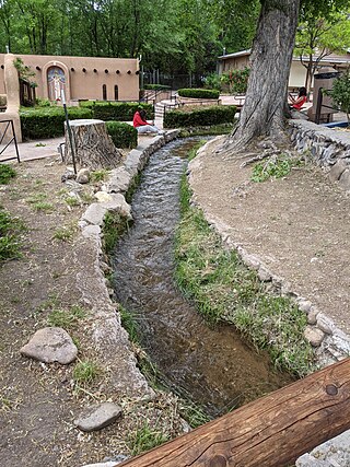
An acequia or séquia is a community-operated watercourse used in Spain and former Spanish colonies in the Americas for irrigation. Acequias are found in parts of Spain, the Andes, northern Mexico, and the modern-day American Southwest.

Old Town is the historic original town site of Albuquerque, New Mexico, for the provincial kingdom of Santa Fe de Nuevo México, established in 1706 by New Mexico governor Francisco Cuervo y Valdés. It is listed on the New Mexico State Register of Cultural Properties as the Old Albuquerque Historic District, and is protected by a special historic zoning designation by the city. However, prior to its establishment as a city in the Santa Fe de Nuevo México province, many indigenous tribes lived there including Diné, Pueblo, Apache, Tiwa, and others. The present-day district contains about ten blocks of historic adobe buildings surrounding Old Town Plaza. On the plaza's north side stands San Felipe de Neri Church, a Spanish colonial church constructed in 1793.

Dixon is an unincorporated community located in Rio Arriba County, New Mexico, United States, on New Mexico State Road 75, just east of New Mexico State Road 68, in the north-central part of the state, and is approximately 20 miles (32 km) southwest of Taos. The elevation of Dixon is 6,028 feet (1,837 m) above sea level. It is on the banks of the Embudo Creek, a tributary of the Rio Grande. Embudo Creek flows into the Rio Grande two miles (3.2 km) downstream from Dixon.

El Camino Real de Tierra Adentro, also known as the Silver Route, was a Spanish 2,560-kilometre-long (1,590 mi) road between Mexico City and San Juan Pueblo, New Mexico, that was used from 1598 to 1882. It was the northernmost of the four major "royal roads" that linked Mexico City to its major tributaries during and after the Spanish colonial era.

Almoloya de Juárez is a town in the State of Mexico and the seat of the municipality of Almoloya de Juárez. The name Almoloya comes from the Nahuatl, that is properly Almoloyan, composed of: atl, "water"; molo "impersonal voice of moloni, to flow the source" and yan, "place"; that it means "place where flows the water source".
Polanco is a neighborhood in the Miguel Hidalgo borough of Mexico City. Polanco is an affluent colonia, noted for its luxury shopping along Presidente Masaryk Avenue, the most expensive street in Mexico, as well as for the numerous prominent cultural institutions located within the neighborhood.

Tlaxiaco is a city, and its surrounding municipality of the same name, in the Mexican state of Oaxaca. It is located in the Tlaxiaco District in the south of the Mixteca Region, with a population of about 17,450.
Jiquipilco Municipality is one of the municipalities of the State of Mexico in Mexico. It is north of the Toluca Valley, part of the region consisting of the southern and western slopes of Cerro La Catedral, which has a concentration of speakers of the Otomi language. It is about 40 km from Toluca, the state capital. The name is a corruption of Nahuatl “Xiquipilco”, meaning “in the saddlebags”. Jiquipilco is situated on the transversal volcanic axis that crosses Mexico in an area surrounded by lakes and volcanoes. This portion is called "Anahuac”.

Hacienda San José de Miravalle is a former mezcal-producing hacienda and currently a rural inactive community of the municipality of San Martín de Hidalgo in central Jalisco, Mexico. During the early twentieth-century, the hacienda was known for its productivity of mezcal business until the Mexican agrarian reform and other uprisings caused it dissolution.

Martineztown-Santa Barbara is a neighborhood in central Albuquerque, New Mexico, immediately northeast of Downtown. Originating as a small farming village in the 1850s, it is one of the city's oldest neighborhoods and retains a distinct character, with winding streets, irregular lots, and adobe vernacular buildings reminiscent of other old Hispanic communities in northern New Mexico.
The Cuernavaca Municipality is one of 36 municipalities in the State of Morelos, Mexico. Located in the northwest of the state, it consists of the City of Cuernavaca, which is the state and municipal capital, as well as other, smaller towns. The population is 378,476 (2020).

Carache is one of the 20 municipalities of the state of Trujillo, Venezuela. The municipality occupies an area of 957 km² with a population of 32,820 inhabitants according to the 2011 census.
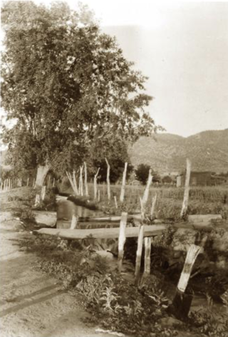
The Acequia Madre is a historical irrigation ditch that flows through the city of Santa Fe, New Mexico. It has been operating for more than 500 years, and is part of the acequia system found throughout New Mexico.
Losoya is an unincorporated community in Bexar County, Texas, United States.
References
- 1 2 Gutierrez, A.E. (Tony) (January 22, 1993). "Sacred Heart Celebrates 98 Years". Del Rio News Herald. Retrieved June 29, 2017– via Newspapers.com.
- 1 2 3 4 5 6 7 8 Acosta, Teresa Palomo (June 15, 2010). "Losoya Taylor, Paula". Handbook of Texas Online. Texas State Historical Association. Retrieved June 29, 2017.
- 1 2 "Brown Plaza Kindled SF Pride". Del Rio News Herald. January 24, 1982. Retrieved June 29, 2017– via Newspapers.com.
- ↑ Zumwalt, Glenda (July 4, 1977). "Early Del Rioans Fought to Survive". Del Rio News Herald. Retrieved June 29, 2017– via Newspapers.com.
- ↑ Gutierrez, A.E. (Tony) (September 30, 1998). "San Felipe Will Survive". Del Rio News Herald. Retrieved June 29, 2017– via Newspapers.com.
- ↑ "Painting for Book Cover". Del Rio News Herald. February 2, 1976. Retrieved June 29, 2017– via Newspapers.com.
- 1 2 Gonzales, Diana (October 25, 1987). "Loma de la Cruz to Get Historical Marker Today". Del Rio News Herald. Retrieved June 29, 2017– via Newspapers.com.
- ↑ "Grande Loma Cemetery". Del Rio News Herald. November 28, 2016. Retrieved 2017-06-29.
- ↑ Thomas, Ann (October 17, 1987). "El Cemeterio Viejo Loma de la Cruz to Get Historical Marker". Del Rio News Herald. Retrieved June 29, 2017– via Newspapers.com.
- ↑ Carmack, George (August 22, 1976). "Del Rio Tale Fascinates". San Antonio Express. Retrieved June 29, 2017– via Newspapers.com.
- ↑ Garza, Cynthia (October 16, 1983). "Comite Cultural Official Sees New Sense of Direction". Del Rio News Herald. Retrieved June 29, 2017– via Newspapers.com.
- ↑ "Historical Markers in Val Verde County". Val Verde County Historical Commission. Retrieved 2017-06-29.