Payne's Creek

Last updated

Coordinates: 40°15′37″N122°11′15″W / 40.26028°N 122.18750°W / 40.26028; -122.18750 [1]

Geographic coordinate system Coordinate system

A geographic coordinate system is a coordinate system that enables every location on Earth to be specified by a set of numbers, letters or symbols. The coordinates are often chosen such that one of the numbers represents a vertical position and two or three of the numbers represent a horizontal position; alternatively, a geographic position may be expressed in a combined three-dimensional Cartesian vector. A common choice of coordinates is latitude, longitude and elevation. To specify a location on a plane requires a map projection.

Contents

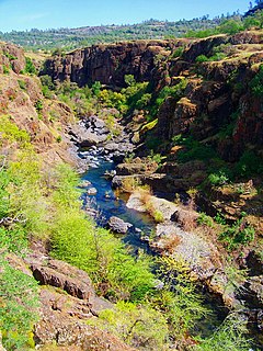
Payne's Creek is a 33.7-mile-long (54.2 km) [2] natural watercourse in Tehama County, California. The creek was apparently originally called Paines Creek according to an 1879 land survey map of the area. The town of Paynes Creek was named after the creek. The creek most likely was named after James S. Payne, the proprietor of a local sawmill. [3]

Tehama County, California County in California, United States

Tehama County is a county located in the northern part of the U.S. state of California. As of the 2010 census, the population was 63,463. The county seat and largest city is Red Bluff.

Stream A body of surface water flowing down a channel

A stream is a body of water with surface water flowing within the bed and banks of a channel. The stream encompasses surface and groundwater fluxes that respond to geological, geomorphological, hydrological and biotic controls.

Paynes Creek, California census-designated place in California, United States

Paynes Creek is a census-designated place (CDP) in Tehama County, California. It is 23 miles (37 km) east of Red Bluff. Its ZIP code is 96075 and telephone prefixes follow (530-597-xxxx), which is shared with the town of Dales, about 9 miles (14 km) to the west. Paynes Creek sits at an elevation of 1,949 feet (594 m). The 2010 United States census reported Paynes Creek's population was 57.

The Payne's Creek watershed contains forested reaches, and also provides habitat for numerous understory flora and fauna. An example wildflower found in the watershed is the poppy Calochortus luteus , which is at its northern limit at the location of the Payne's Creek watershed. [4]

Understory layer of plant life growing above the shrub layer and below the canopy

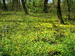
In forestry and ecology, understory comprises plant life growing beneath the forest canopy without penetrating it to any great extent, but above the forest floor. Only a small percentage of light penetrates the canopy so understory vegetation is generally shade tolerant. The understory typically consists of trees stunted through lack of light, other small trees with low light requirements, saplings, shrubs, vines and undergrowth. Small trees such as holly and dogwood are understory specialists.

Flora inventory of plant species in a given region

Flora is the plant life occurring in a particular region or time, generally the naturally occurring or indigenous—native plant life. The corresponding term for animal life is fauna. Flora, fauna and other forms of life such as fungi are collectively referred to as biota. Sometimes bacteria and fungi are also referred to as flora, as in the terms gut flora or skin flora.

Fauna set of animal species in any particular region and time

Fauna is all of the animal life present in a particular region or time. The corresponding term for plants is flora. Flora, fauna and other forms of life such as fungi are collectively referred to as biota. Zoologists and paleontologists use fauna to refer to a typical collection of animals found in a specific time or place, e.g. the "Sonoran Desert fauna" or the "Burgess Shale fauna". Paleontologists sometimes refer to a sequence of faunal stages, which is a series of rocks all containing similar fossils. The study of animals of a particular region is called faunistics.

See also

Line notes

  1. U.S. Geological Survey Geographic Names Information System: Paynes Creek
  2. U.S. Geological Survey. National Hydrography Dataset high-resolution flowline data. The National Map, accessed March 10, 2011
  3. "Place Names" (PDF). Tehama County Department of Education. p. 43. Archived from the original (PDF) on 8 May 2017. Retrieved 25 March 2018.
  4. C. Michael Hogan. 2009

Related Research Articles

Keyesville, California Unincorporated community in California, United States

Keyesville is an unincorporated community in Kern County, California. It is located 2 miles (3.2 km) west of Lake Isabella and the Kern River Valley, at an elevation of 2,848 feet (868 m). Keyesville, founded in 1854 is named for Richard M. Keyes, whose discovery of gold in 1853 started the Kern River Gold Rush.

Greenhorn Mountains

The Greenhorn Mountains are a mountain range of the Southern Sierra Nevada, in California. They are protected within the Sequoia National Forest.

Big Chico Creek river in the United States of America

Big Chico Creek originates near Colby Mountain, located in Tehama County, California. The creek flows 46 miles (74 km) to its confluence with the Sacramento River in Butte County. The creek's elevation ranges from 120 feet (37 m) above sea level at the Sacramento River to 5,000 feet (1,500 m) near Colby Mountain, as shown on the Ord Ferry USGS quadrangle.

<i>Calochortus luteus</i> species of plant

Calochortus luteus, the yellow mariposa lily, is a mariposa lily endemic to California.

Zayante Creek is a 10.3-mile-long (16.6 km) stream within the San Lorenzo River watershed in Santa Cruz County, California, United States. The U.S. government has designated Zayante Creek as impaired with respect to sediment. Lompico Creek, a tributary of Zayante Creek, is listed for impairment by pathogens. In the period 1998 to 2000 a restoration project was conducted for this stream to improve anadromous fish passage, rearing and spawning. There has been a permanent U.S. Geological Survey gauging station on Zayante Creek which has operated since the year 1959; the mean altitude of the Zayante Basin, carved within the western slopes of the Santa Cruz Mountains, is 1,000 feet (300 m). Significant tributaries to Zayante Creek are Lompico Creek and Bean Creek.

Bean Creek is a 9.1-mile-long (14.6 km) stream that rises on the western slopes of the Santa Cruz Mountains and discharges to Zayante Creek. This stream traverses relatively rugged, forested lands and is the locus of an important fossil bearing formation. These fossils are embedded in the Lower Santa Margarita Formation and include Astrodapsis spatiosus;also rare species of gastropod Thais cf. lapillis, and shark teeth The watershed area is 8.81 square miles (22.8 km2) and the peak flow of Bean Creek has been measured at 1,380 cubic feet (39 m3) per second. Since 2001 the Scotts Valley Water District has monitored regularly at three stations within Bean Creek for heavy metals and nitrates. Significant groundwater recharge occurs in the streambed of Bean Creek.

The Spenceville Wildlife Area is an 11,448-acre (46.33 km2) wildlife preserve managed by the California Department of Fish and Wildlife. It is located in the Sierra Nevada Foothills, within Nevada County and Yuba County of northern California.

Dye Creek is an 18.2-mile-long (29.3 km) watercourse in Tehama County, California, United States, that is tributary to the Sacramento River. Dye Creek's watershed is situated in north-central California. The Dye Creek watershed contains rugged terrain areas of oak-studded forest, and also provides habitat for numerous understory flora and fauna. An example forb found in the watershed is the poppy Calochortus luteus, which is at its northern limit around the Dye Creek watershed.

Snell Creek is a 2.1-mile-long (3.4 km) watercourse in Napa County, California. It is situated approximately five miles north of Aetna Springs and is a tributary of Butts Creek, which ultimately merges into Putah Creek.

The Missimer Wildflower Preserve is a protected native grassland in Napa County, California. The preserve is situated on considerable serpentine soil, leading to specially adapted flora. Situated within Snell Valley, the preserve is noted for its biodiversity of flora. An example of native wildflowers in the Snell Creek watershed is yellow mariposa lily, Calochortus luteus.

Lime Kiln Creek is a stream within Tulare County in central California. An alternative name for this creek is Dry Creek.

Panoche Pass

Panoche Pass is a mountain pass within the Diablo Range in San Benito County, California connecting the southern extremity of the Santa Clara Valley in the west to the Panoche Valley and San Joaquin Valley in the east. The name Panoche Pass is used for the United States Geological Survey quadrangle map for the local area. County Route J1, also known as the Panoche Road, traverses the pass.

Beegum Creek is a stream located in Shasta and Tehama counties, in the U.S. state of California. The stream runs 16 miles (26 km) before it empties into Cottonwood Creek.

Thomes Creek

Thomes Creek is a major watercourse on the west side of the Sacramento Valley in Northern California. The creek originates in the Coast Ranges and flows east for about 62 miles (100 km) to join the Sacramento River, at a point about 7 miles (11 km) northeast of Corning in Tehama County.

Beegum is an unincorporated community in Shasta and Tehama counties, in the U.S. state of California.

Cold Fork is an unincorporated community in Tehama County, in the U.S. state of California.

El Camino is an unincorporated community in Tehama County, in the U.S. state of California.

Red Bank is an unincorporated community in Tehama County, in the U.S. state of California.

References

See also