
The Berwyn range is an isolated and sparsely populated area of moorland in the northeast of Wales, roughly bounded by Llangollen in the northeast, Corwen in the northwest, Bala in the southwest, and Oswestry in the southeast.

Sabalan is an inactive stratovolcano in Ardabil Province of northwestern Iran.

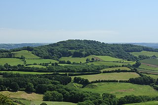
Pilsdon Pen is a 277-metre (909 ft) hill in Dorset in South West England, situated at the north end of the Marshwood Vale, approximately 4.5 miles (7.2 km) west of Beaminster. It is Dorset's second highest point and has panoramic views extending for many miles. It was bequeathed to the National Trust by the Pinney family in 1982. For many years it was thought to be Dorset's highest hill, until modern survey revealed that nearby Lewesdon Hill was 2 metres higher.

Walbury Hill is a summit of the North Wessex Downs in Berkshire, England. At 297 metres (974 ft) above sea level, it is the highest natural point in South East England.
Lewesdon Hill is a hill in west Dorset, England. With a maximum elevation of 279 m (915 ft), it is the highest point in Dorset.

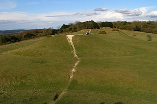
Swyre Head is the highest point of the Isle of Purbeck in Dorset, on the south coast of England. The hill Swyre Head lies about 2 kilometres (1 mi) southwest of the village Kingston, about 5 kilometres (3 mi) south of Corfe Castle and 8 kilometres (5 mi) west of Swanage.

Beacon Hill is one of the highest viewpoints in the hinterland of Poole Harbour, Dorset. Its tree-covered summit reaches 84 metres (276 ft) above sea level and there is a public footpath running roughly north to south over the top. Historically it was one of a series of beacons used to warn of the advancing Spanish Armada. The earlier name for the hill was Lytchett Beacon.
The Ankum Heights, also called the Fürstenau Hills, are a ridge of hills up to 140 m high in the western part of the state of Lower Saxony on the North German Plain.

At 258 metres, Bell Hill is one of the highest hills in the county of Dorset, England and a high point on the Wessex Ridgeway.

Weston Hill is a hill, 250 metres (820 ft) high, on the A 356, 1 kilometre west of Corscombe in the county of Dorset in southern England. It is located within the Dorset Downs. It is named after the hamlet of Weston to the northeast.

Warren Hill is a prominent elevation, 215 metres (705 ft) high, 1 kilometre southwest of the hamlet of Hooke, in the county of Dorset in southern England. Its prominence of 51 metres (167 ft) means it is listed as one of the Tumps. It is located within the Dorset Downs.

Chardown Hill is a prominent, rounded hill, 194 metres (636 ft) high, just to the southwest of the village of Morcombelake in the county of Dorset in southern England. It overlooks the Dorset coast around 1½ kilometres to the south. Its prominence of 63 metres (207 ft) means it is listed as one of the Tumps. It is located within the South Dorset Downs.

Blackdown Hill is a prominent elevation, 215 metres (705 ft) high, 5 miles (8.0 km) south west of the town of Crewkerne, in the county of Dorset in the south west of England. Its prominence of 34 metres (112 ft) means it is listed as one of the Tumps. It runs parallel to the B3165 towering over the village of Blackdown and hamlet of Kittwhistle at the foot of the eastern flanks of the ridge.

Conegar Hill is a prominent rise, 214 metres (702 ft) high, just north of the village of Broadwindsor in the Yeovil Scarplands, in the county of Dorset in southern England. It has a prominence of 51 metres (167 ft) which classifies it as one of the Tumps.

Bookham Knoll is a rounded hill, 211 metres (692 ft) high, about 1 kilometre southeast of the village of Buckland Newton in the county of Dorset in southern England. Its prominence of 43 metres (141 ft) qualifies it as one of the Tumps. It is located within the Dorset Downs.
Farleigh Hill is one of the highest points in the county of Hampshire, England. It is part of the Hampshire Downs and reaches a height of 208 metres (682 ft) above sea level. Its prominence of 34 metres (112 ft) just qualifies it as a ('P30') TuMP.

Diamond Hill or Bengooria is an isolated peak overlooking the village of Letterfrack, in the northwest corner of the Twelve Bens in Connemara National Park in County Galway, Ireland. At only 442 metres (1,450 ft), it does not rank as an Arderin, or a Vandeleur-Lynam; however, it has the prominence to rank as a Marilyn. Diamond Hill is It lies just west of Knockbrack and the small massif of Benbrack, and looks into the Polladirk valley, around which several major Bens are located. Despite its moderate size and isolation, Diamond Hill is a popular peak with tourists due to its paths and boarded mountain trail, and relative ease of access, together with well-regarded views of the core Twelve Bens range, and western Connemara.
Bow Hill is an elongated hill ridge, 206 metres (676 ft) high, and running roughly from north to south in the South Downs, in the county of West Sussex, England. It has a prominence of 74 metres.
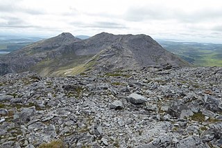
Benbreen at 691 metres (2,267 ft), is the 100th–highest peak in Ireland on the Arderin scale, and the 122nd–highest peak on the Vandeleur-Lynam scale. Benbreen lies in the southern end of the Twelve Bens mountain range in the Connemara National Park in Galway, Ireland. Benbreen is the 4th-tallest mountain of the Twelve Bens range, after Benbaun 729 metres (2,392 ft), Bencorr 711 metres (2,333 ft), and Bencollaghduff 696 metres (2,283 ft). Benbreen's profile is of a "high narrow rocky ridge with several summits", than a typical "peaked mountain".

Ben Lugmore at 803 metres (2,635 ft) is the 29th-highest peak in Ireland on the Arderin scale, and the 37th-highest peak on the Vandeleur-Lynam scale. It is in a horseshoe-shaped massif that includes the slightly higher peak of Mweelrea at 814 metres (2,671 ft), the highest mountain in the Irish province of Connacht. The massif is between Killary Harbour and Doo Lough, in Mayo.
