Related Research Articles

The Pearl River is a river in the U.S. states of Mississippi and Louisiana. It forms in Neshoba County, Mississippi from the confluence of Nanih Waiya and Tallahaga creeks, and has a meander length of 444 miles (715 km). The lower part of the river forms part of the boundary between Mississippi and Louisiana.

The Quabbin Reservoir is the largest inland body of water in Massachusetts, and was built between 1930 and 1939. Along with the Wachusett Reservoir, it is the primary water supply for Boston, 65 miles (105 km) to the east, and 40 other cities and towns in Greater Boston. The Quabbin also supplies water to three towns west of the reservoir and acts as backup supply for three others. By 1989, it supplied water for 2.5 million people, about 40% of the state's population at the time. It has an aggregate capacity of 412 billion US gallons (1,560 GL) and an area of 38.6 square miles (99.9 km2).

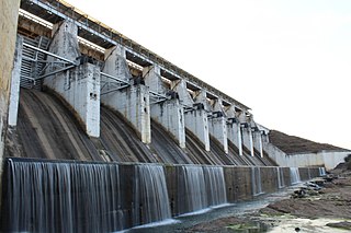
The Ross Barnett Reservoir, often called the Rez, is a reservoir of the Pearl River between Madison and Rankin counties in the U.S. state of Mississippi. The 33,000-acre (130 km2) lake serves as the state's largest drinking water resource, and is managed by the Pearl River Valley Water Supply District. The lake features 105 miles (169 km) of shoreline impounded on the south by a 3.5-mile (5.6 km) man-made dam and spillway. The western shore is bounded by the historic Natchez Trace Parkway.

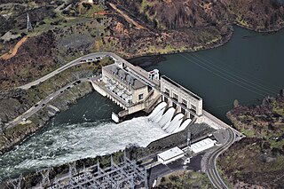
Oroville Dam is an earthfill embankment dam on the Feather River east of the city of Oroville, California, in the Sierra Nevada foothills east of the Sacramento Valley. At 770 feet (235 m) high, it is the tallest dam in the U.S. and serves mainly for water supply, hydroelectricity generation, and flood control. The dam impounds Lake Oroville, the second-largest reservoir in California, capable of storing more than 3.5 million acre-feet (1.1×10¹² US gal; 4.3×10⁹ m3).

Lake Oroville is a reservoir formed by the Oroville Dam impounding the Feather River, located in Butte County, northern California. The lake is situated 5 miles (8 km) northeast of the city of Oroville, within the Lake Oroville State Recreation Area, in the western foothills of the Sierra Nevada. Known as the second-largest reservoir in California, Lake Oroville is treated as a keystone facility within the California State Water Project by storing water, providing flood control, recreation, freshwater releases to assist in controlling the salinity intrusion into the Sacramento-San Joaquin Delta and protecting fish and wildlife.

Stanford Reservoir is a drinking water reservoir on the River Avon, England. It lies on the county boundary between Leicestershire and Northamptonshire near the village of Stanford-on-Avon.

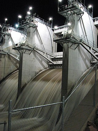
The Bonnet Carré Spillway is a flood control operation in the Lower Mississippi Valley. Located in St. Charles Parish, Louisiana, about 12 miles (19 km) west of New Orleans, it allows floodwaters from the Mississippi River to flow into Lake Pontchartrain and thence into the Gulf of Mexico. The spillway was constructed between 1929 and 1931, following the Great Mississippi Flood of 1927, and has been designated as a National Historic Civil Engineering Landmark by the American Society of Civil Engineers.

Hansen Dam is a flood control dam in the northeastern San Fernando Valley, in the Lake View Terrace neighborhood of Los Angeles, California. The dam was built by the U.S. Army Corps of Engineers, Los Angeles District in 1940. Hansen Dam was named after horse ranchers Homer and Marie Hansen, who established a ranch in the 19th century.

Gavins Point Dam is a 1.9 mi (3 km) long embankment rolled-earth and chalk-fill dam which spans the Missouri River and impounds Lewis and Clark Lake. The dam joins Cedar County, Nebraska with Yankton County, South Dakota a distance of 811.1 river miles (1,305 km) upstream of St. Louis, Missouri, where the river joins the Mississippi River. The dam and hydroelectric power plant were constructed as the Gavins Point Project from 1952 to 1957 by the United States Army Corps of Engineers as part of the Pick-Sloan Plan. The dam is located approximately 4 miles (6.4 km) west or upstream of Yankton, South Dakota.
The Ross River Dam is a rock and earthfill-filled embankment dam across the Ross River, located between Kelso and Mount Stuart in the City of Townsville in northern Queensland, Australia. Built initially for flood control, Lake Ross, the impoundment created by the dam, serves as one of the major potable water supplies for the region.

Ujjani Dam, also known as Bhima Dam or Bhima Irrigation Project, on the Bhima River, a tributary of the Krishna River, is an earthfill cum Masonry gravity dam located near Ujjani village of Madha Taluk in Solapur district of the state of Maharashtra in India.
The Water Resources Development Act of 1992, Pub. L.Tooltip Public Law 102–580, was enacted by Congress of the United States on October 31, 1992. Most of the provisions of WRDA 1992 are administered by the United States Army Corps of Engineers.

The 1979 Easter flood was one of the most costly and devastating floods to ever occur in Mississippi, United States, with $500–700 million in damages. It was the result of the Pearl River being overwhelmed by severe rain upstream. Floodwaters sent the Pearl River 15 feet above flood stage. More than 17,000 residents of Jackson, Flowood, Pearl, Richland, and other settlements in the Jackson metropolitan area were forced from their homes. The flooding of the Pearl River placed most of the streets of Jackson, the state's capital city, under several feet of water. This flood resulted from a storm system that was the same storm system that, just a few days earlier, produced the Red River valley tornado outbreak that is particularly well-known because of the devastating Wichita Falls, Texas tornado that killed 42, injured over 1,700, left an estimated 20,000 homeless, and caused, in 1979 dollars, approximately $400 million in damages.
Tenughat Dam is an earthfill dam with composite masonry cum concrete spillway across the Damodar River at Tenughat in Petarwar block of Bokaro district in the Indian state of Jharkhand.
Keswick Dam is a concrete gravity dam on the Sacramento River about 2 miles (3.2 km) northwest of Redding, California. Part of the U.S. Bureau of Reclamation's Central Valley Project, the dam is 157 feet (48 m) high and impounds the Keswick Reservoir, which has a capacity of 23,800 acre⋅ft (29,400,000 m3). The dam's power plant has three turbines with a generating capacity of 117 megawatts (MW), which, in 1992, was uprated from its original 75 MW. The dam and reservoir serve as an afterbay to regulate peaking power releases from the Shasta Dam upstream.

Coal Bluff Campground and Park is a semi-private campground and recreation area located along the Pearl River in Scott County, Mississippi, near the community of Ludlow. The area is managed by Pearl River Valley Water Supply District (PRVWSD).

Nacimiento Dam is a dam on the Nacimiento River about 10 miles (16 km) northwest of Paso Robles, California in the United States. The primary purpose of the dam is to provide groundwater recharge for agriculture in Monterey County and northern San Luis Obispo County supported by the Salinas Valley aquifer, as well as flood control, domestic water supply, and hydropower. It forms Lake Nacimiento, popular for boating, fishing and camping, and known locally as the "Dragon Lake" due to its shape.
Fannin is an unincorporated community located in northwest Rankin County, Mississippi, United States, near the cities of Jackson, Flowood, Brandon, and Ridgeland, loosely bordered by the Pearl River and Pelahatchie Creek. Originally occupied by Native Americans, the eventual settlement became a thriving agricultural-based town post Civil War, through the first half of the twentieth century. The decline of the railroads, the impoundment of the Pearl River, and the general migration of settlers toward nearby cities led to Fannin's eventual dis-incorporation and transition into a mostly rural residential community.

Lake Hico was a cooling pond reservoir built on 16th section school land in Jackson, Mississippi, in the 1950s. Its primary purpose was to provide water for the adjacent Rex Brown Plant, which generates electricity with steam. Initially, Lake Hico was open to the public for recreation. The lake was closed to the public in the late 1960s, along with the public swimming pools in Jackson, due to racial prejudices preventing peaceful integration of public swimming holes. Lake Hico was built as a cooling lake for the Rex Brown Electric Generating complex. Part of the agreement with the Hinds County board of supervisors was to have a public recreation lake and a lake for the intake and the exhaust of water for cooling for the generators. Thus the two lakes. It was originally built as a fuel oil based generating system but was later converted to natural gas when oil got so expensive in the 1970’s. The reasons why it was finally closed to the public were 1- the Barnett Reservoir opened and most people who had formerly used the lake went there and 2- the liability costs to MP&L skyrocketed after there was a couple of drownings. The fact that integration of such public spaces was being attempted by some and resisted by others in Jackson, Mississippi at the time is possibly pertinent. The adjacent Hico Park was closed after a lawsuit to integrate that park was filed as late as 1975. The Rex Brown plant was just recently totally dismantled.
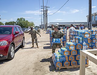
A public health crisis in and around the city of Jackson, Mississippi, began in late August 2022 after the Pearl River flooded due to severe storms in the state. The flooding caused the O. B. Curtis Water Treatment Plant, the city's largest water treatment facility, which was already running on backup pumps due to failures the month prior, to stop the treatment of drinking water indefinitely. This resulted in approximately 150,000 residents of the city being left without access to safe drinking water. Mississippi Governor Tate Reeves issued a state of emergency and United States President Joe Biden declared a federal disaster to trigger federal aid. Reeves withdrew the state of emergency on November 22. The crisis triggered a political debate regarding racial discrimination, infrastructure neglect, and shifting local demographics.
References
- ↑ Peer report #471, A Review of the Pearl River Valley Water Supply District, Background, 2004, pg. 3
- ↑ PRVWSD website/About Us
- ↑ Peer report #471, A Review of the Pearl River Valley Water Supply District; Executive Summary, The Districts Accountability to Residents, 2004, Appen. viii
- ↑ Mississippi Water Resources, Pearl River Valley Water Supply District
- ↑ Peer report #471, A Review of the Pearl River Valley Water Supply District; Executive Summary, The Districts Accountability to Residents, 2004, Appen. viii
- ↑ Peer report #471, A Review of the Pearl River Valley Water Supply District; Executive Summary, Background, 2004, Appen. vii
- ↑ Peer report #471, A Review of the Pearl River Valley Water Supply District; Background, Composition of Board of Directors, 2004, pg. 4
- ↑ Mississippi State University, Water Resources Research Institute, Aquatic Plant Management Support for the Pearl River Valley Water Supply District
- ↑ The Rez News,PRVWSD Spraying for Hydrillia, September 29, 2011
- ↑ Mississippi State University, Water Resources Research Institute, Aquatic Plant Management Support for the Pearl River Valley Water Supply District
- ↑ PRVWSD website/About Us
- ↑ Peer report #471, A Review of the Pearl River Valley Water Supply District; Executive Summary, The Districts Accountability to Residents, 2004, Appen. viii
- ↑ The Rez News, The Control Tower, July 14, 2010
- ↑ Report by the Comptroller of the United States,Improvements Being Made in Flood Fighting Capabilities in the Jackson, Mississippi Area
- ↑ Jackson Free Press, Lessons of the 1979 Easter Flood, March 03, 2010
- ↑ Jackson Free Press, Plan B, Flood Control Projects Beyond Lakes and Levees, February 17, 2010
- ↑ Regulations of the Pearl River Valley Water Supply District An Agency of the State of Mississippi Relating to the Use of Reservoir Project Area, December 2010, pg. 1
- ↑ PRVWSD website/Reservoir Patrol
- ↑ PRVWSD website/Real Estate
- ↑ Mississippi State University, Water Resources Research Institute, Aquatic Plant Management Support for the Pearl River Valley Water Supply District
- ↑ PRVWSD website/About Us
- ↑ Mississippi Water Resources, Pearl River Valley Water Supply District