
Delaware City is a city in New Castle County, Delaware, United States. The population was 1,885 as of 2020. It is a small port town on the eastern terminus of the Chesapeake and Delaware Canal and is the location of the Forts Ferry Crossing to Fort Delaware on Pea Patch Island.

Lumberland is a town in Sullivan County, New York, United States. The population was 2,243 at the 2020 census.

Hancock is a town in Delaware County, New York, United States. The town contains a village, also named Hancock. The town is in the southwest part of the county. The population was 2,764 at the 2020 census. The town is the largest by area in Delaware County. The town borders two other counties, Sullivan County, NY, to the south and Wayne County, PA, to the west. The town is located partially in the Catskill Park.

Delaware Bay is the estuary outlet of the Delaware River on the northeast seaboard of the United States, lying between the states of Delaware and New Jersey. It is approximately 782 square miles (2,030 km2) in area, the bay's freshwater mixes for many miles with the saltwater of the Atlantic Ocean.
Finns Point is a small promontory in Pennsville Township, Salem County, New Jersey, and New Castle County, Delaware, located at the southwest corner of the cape of Penns Neck, on the east bank of the Delaware River near its mouth on Delaware Bay. Due to the wording of the original charter defining the boundaries of New Jersey and Delaware, part of the promontory is actually enclosed within the state of Delaware's border, due to tidal flow and the manner in which the borders between New Jersey and Delaware were first laid out. Therefore, this portion of Finns Point, also called The Baja, is an exclave of Delaware, cut off from the rest of the state by Delaware Bay. The area is about 10 miles (16 km) south of the city of Wilmington, and directly across the Delaware River from the New Castle area, and the Delaware River entrance to the Chesapeake & Delaware Canal. Pea Patch Island, part of the state of Delaware, sits in the channel of the river facing the promontory.

Reedy Island is a small island in the middle of the channel of the Delaware River near its mouth on the Delaware Bay in the U.S. state of Delaware. It is about one mile (1.6 km) east of Port Penn, Delaware and five miles (8 km) southwest of Salem, New Jersey.

The East Branch Delaware River is one of two branches that form the Delaware River. It is approximately 75 mi (121 km) long, and flows through the U.S. state of New York. It winds through a mountainous area on the southwestern edge of Catskill Park in the Catskill Mountains for most of its course, before joining the West Branch along the northeast border of Pennsylvania with New York. Much of it is paralleled by State Route 30.

Upper Black Eddy, locally referred to as UBE, is a village located in northern Bucks County, Pennsylvania, United States. The village is 58 miles (93 km) west-southwest of New York City and 45 miles (72 km) north of Philadelphia.

The Twelve-Mile Circle is an approximately circular arc that forms most of the boundary between Delaware and Pennsylvania. It is a combination of different circular arcs that have been feathered together.

New York State Route 97 (NY 97) is a 70.53-mile-long (113.51 km) north–south scenic route in southern New York in the United States. It runs from U.S. Route 6 (US 6) and US 209 in Port Jervis to NY 17 in Hancock. Its most famous feature is the Hawk's Nest, a tightly winding section of the road along the Delaware River, located a few miles north of Port Jervis. NY 97 intersects NY 52 in Narrowsburg and indirectly connects to three Pennsylvania state highways due to its proximity to the state line.

Fort Delaware is a former harbor defense facility, designed by chief engineer Joseph Gilbert Totten and located on Pea Patch Island in the Delaware River. During the American Civil War, the Union used Fort Delaware as a prison for Confederate prisoners of war, political prisoners, federal convicts, and privateer officers. A three-gun concrete battery of 12-inch guns, later named Battery Torbert, was designed by Maj. Charles W. Raymond and built inside the fort in the 1890s. By 1900, the fort was part of a three fort concept, the first forts of the Coast Defenses of the Delaware, working closely with Fort Mott in Pennsville, New Jersey, and Fort DuPont in Delaware City, Delaware. The fort and the island currently belong to the Delaware Department of Natural Resources and Environmental Control (DNREC) and encompass a living history museum, located in Fort Delaware State Park.

Hale Eddy is a hamlet in Delaware County, New York, United States. It is located south-southeast of Deposit on New York State Route 17 (NY 17). At-grade intersections occur along NY 17 through Hale Eddy though the highway is otherwise a freeway on either side of the hamlet. The West Branch Delaware River flows east through the hamlet.
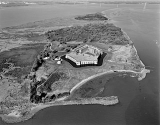
Fort Delaware State Park is a 288-acre (117 ha) Delaware state park on Pea Patch Island in New Castle County, Delaware. A fortress was built on Pea Patch Island by the United States Army in 1815, near the conclusion of the War of 1812, to protect the harbors of Wilmington, Delaware and Philadelphia, Pennsylvania. The fort was burned and rebuilt in the years prior to the American Civil War, and soon after the start of the war the fort was converted to a Prisoner of War camp. Fort Delaware continued to protect the mouth of the Delaware River through World War I and II. Pea Patch Island and Fort Delaware was declared surplus land by the United States Department of Defense in 1945.

The Supawna Meadows National Wildlife Refuge is a component of the Delaware River estuary in Salem County, New Jersey, it is just north of the Salem River and south of Pennsville.
Peas Eddy Brook flows into the East Branch Delaware River by Peas Eddy, New York.
Fishs Eddy is a hamlet in Delaware County, New York, United States. The community is located along the East Branch Delaware River, 5.5 miles (8.9 km) east of Hancock, off New York State Route 17 at Exit 89. Fishs Eddy has a post office with ZIP code 13774.
Lakin Brook is a river in Delaware County, New York. It drains Pierce Pond and flows west, then turns north, then west again before converging with Peas Eddy Brook east-southeast of Peas Eddy.
Pea Brook is a river in Delaware County and Sullivan County in New York. It flows into the Delaware River in Long Eddy.
Pierce Pond is a small lake located north of the hamlet of French Woods in Delaware County, New York. Pierce Pond drains northwest via an Lakin Brook which flows into Peas Eddy Brook.
Partridge Island is an island in Delaware County, New York. It is located northwest of Fishs Eddy, on the East Branch Delaware River.

