
Hawaii is the largest island in the United States, located in the state of Hawaii. It is the southeasternmost of the Hawaiian Islands, a chain of volcanic islands in the North Pacific Ocean. With an area of 4,028 square miles (10,430 km2), it has 63% of the Hawaiian archipelago's combined landmass. However, it has only 13% of the archipelago's population. The island of Hawaiʻi is the third largest island in Polynesia, behind the north and south islands of New Zealand.

Blanco County is a United States county located in the U.S. state of Texas. It is located in Central Texas and its county seat is Johnson City.
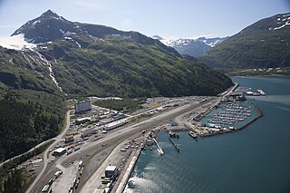
Whittier is a city at the head of the Passage Canal in the U.S. state of Alaska, about 58 miles (93 km) southeast of Anchorage. The city is within the Chugach Census Area, one of the two entities established in 2019 when the former Valdez–Cordova Census Area was dissolved. It is also a port for the Alaska Marine Highway. The population was 272 at the 2020 census, having increased from 220 in 2010. The city is notable for the fact that almost all of its residents live in the Begich Towers Condominium, earning it the nickname of a "town under one roof".
Johnson City is a city and the county seat of Blanco County, Texas, United States. The population was 1,656 at the 2010 census. Founded in 1879 by James P. Johnson, it was named for early settler Sam E. Johnson, Sr. Johnson City is part of the Texas-German belt region.

Guayaquil, officially Santiago de Guayaquil, is the largest city in Ecuador and also the nation's economic capital and main port. The city is the capital of Guayas Province and the seat of Guayaquil Canton. The city is located on the west bank of the Guayas River, which flows into the Pacific Ocean at the Gulf of Guayaquil.

The 1964 Alaskan earthquake, also known as the Great Alaskan earthquake and Good Friday earthquake, occurred at 5:36 pm AKST on Good Friday, March 27. Across south-central Alaska, ground fissures, collapsing structures, and tsunamis resulting from the earthquake caused about 131 deaths.

Kaikōura is a town on the east coast of the South Island of New Zealand. It is located on State Highway 1, 180 km north of Christchurch. The town has an estimated permanent resident population of 2,360.

U.S. Route 290 is an east–west U.S. Highway located entirely within the state of Texas. Its western terminus is at Interstate 10 southeast of Segovia, and its eastern terminus is at Interstate 610 in northwest Houston. It is the main highway between Houston and Austin and is a cutoff for travelers wanting to bypass San Antonio on Interstate 10. Throughout its length west of Austin, US 290 cuts across mountainous hills comprising the Texas Hill Country and the Edwards Plateau; between Austin and Houston, the highway then travels through gradually hilly grasslands and pine forests comprising the Gulf Coastal Plains.
Chilakaluripet is a city in Palnadu district of the Indian state of Andhra Pradesh. It is the Mandal headquarters of Chilakaluripet Mandal in Narasaraopet Revenue Division.

Wenchuan County is a county in Ngawa Tibetan and Qiang Autonomous Prefecture, Sichuan, China.

The Dominican city of Pedernales is the capital of the Pedernales Province, in the Dominican Republic. It is located in the southwest of the country, on the Dominican Republic–Haiti border, and has a crossing to the Haitian town of Anse-à-Pitres.

Pedernales Canton is a canton of Ecuador, located in the Manabí Province. Its capital is the town of Pedernales. Its population at the 2001 census was 46,876.
The 1906 Ecuador–Colombia earthquake occurred at 10:36:10 (UTC+5) on Wednesday January 31, 1906 off the coast of Ecuador, near Esmeraldas. The earthquake had a moment magnitude of 8.8 and triggered a destructive tsunami that caused at least 500 casualties on the coast of Colombia.
The 1949 Ambato earthquake was the deadliest earthquake in the Western Hemisphere in five years. On August 5, 1949, it struck Ecuador's Tungurahua Province southeast of its capital Ambato and killed 5,050 people. Measuring 6.4 on the scale, it originated from a hypocenter 15 km beneath the surface. The nearby villages of Guano, Patate, Pelileo, and Pillaro were destroyed, and the city of Ambato suffered heavy damage. The earthquake flattened buildings and subsequent landslides caused damage throughout the Tungurahua, Chimborazo, and Cotopaxi Provinces. It disrupted water mains and communication lines and opened a fissure into which the small town of Libertad sank. Moderate shaking from the event extended as far away as Quito and Guayaquil.

The 2016 Ecuador earthquake occurred on April 16 at with a moment magnitude of 7.8 and a maximum Mercalli intensity of VIII (Severe). The very large thrust earthquake was centered approximately 27 km (17 mi) from the towns of Muisne and Pedernales in a sparsely populated part of the country, and 170 km (110 mi) from the capital Quito, where it was felt strongly. Regions of Manta, Pedernales and Portoviejo accounted for over 75 percent of total casualties. Manta's central commercial shopping district, Tarqui, was completely destroyed. Widespread damage was caused across Manabí Province, with structures hundreds of kilometres from the epicenter collapsing. At least 676 people were killed and 16,600 people injured. President Rafael Correa declared a state of emergency; 13,500 military personnel and police officers were dispatched for recovery operations.
Events in the year 2016 in Ecuador.
Rodrigo Canosa Martínez is a Uruguayan footballer who plays as a central defender for Lautaro de Buin of the Segunda División Profesional de Chile. He previously played domestically for El Tanque Sisley, Cerrito, Rampla Juniors, Villa Teresa and Cerro, in Argentina for Olimpo de Bahía Blanca, for América de Cali of Colombia, for Ecuadorian club Delfín, and for Curicó Unido of Chile.
The 1942 Ecuador earthquake or the Guayaquil earthquake occurred on 13 May at 9:06 or 9:13 pm local time with a moment magnitude of Mw 7.9. The temblor struck the coastal (Esmeraldas) region of Manabí Province, Ecuador. It caused damage mainly to cities like Guayaquil, Portoviejo and Guaranda. More than 300 people were killed and the total cost of damage was about US$2.5 million. Ecuador's largest city Guayaquil was the most affected despite the significant distantce from the epicenter. Many reinforced concrete structures in a particular area in the city were completely destroyed, contributing to fatalities.
Anne Meltzer is a seismologist known for her research on earthquakes and the formation of mountain ranges. Her research primarily focused on the evolution of the Earth's lithosphere and the surface processes associated with faulting and deformation in the Earth's crust. Through her own personal research and collaboration with other colleagues, she strived to make advancements in the efficiency and effectiveness of monitoring earthquakes. In addition, her work aimed to effectively reduce earthquake destruction in countries that experience frequent seismic phenomena.

