Soil, also commonly referred to as earth or dirt, is a mixture of organic matter, minerals, gases, liquids, and organisms that together support the life of plants and soil organisms. Some scientific definitions distinguish dirt from soil by restricting the former term specifically to displaced soil.
Pedology is a discipline within soil science which focuses on understanding and characterizing soil formation, evolution, and the theoretical frameworks for modeling soil bodies, often in the context of the natural environment. Pedology is often seen as one of two main branches of soil inquiry, the other being edaphology which is traditionally more agronomically oriented and focuses on how soil properties influence plant communities. In studying the fundamental phenomenology of soils, e.g. soil formation, pedologists pay particular attention to observing soil morphology and the geographic distributions of soils, and the placement of soil bodies into larger temporal and spatial contexts. In so doing, pedologists develop systems of soil classification, soil maps, and theories for characterizing temporal and spatial interrelations among soils. There are a few noteworthy sub-disciplines of pedology; namely pedometrics and soil geomorphology. Pedometrics focuses on the development of techniques for quantitative characterization of soils, especially for the purposes of mapping soil properties whereas soil geomorphology studies the interrelationships between geomorphic processes and soil formation.

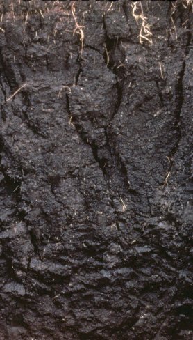
Chernozem, also called black soil, regur soil or black cotton soil, is a black-colored soil containing a high percentage of humus and high percentages of phosphorus and ammonia compounds. Chernozem is very fertile soil and can produce high agricultural yields with its high moisture-storage capacity. Chernozems are a Reference Soil Group of the World Reference Base for Soil Resources (WRB).
USDA soil taxonomy (ST) developed by the United States Department of Agriculture and the National Cooperative Soil Survey provides an elaborate classification of soil types according to several parameters and in several levels: Order, Suborder, Great Group, Subgroup, Family, and Series. The classification was originally developed by Guy Donald Smith, former director of the U.S. Department of Agriculture's soil survey investigations.
In soil science, podzols, also known as podosols, spodosols, or espodossolos, are the typical soils of coniferous or boreal forests and also the typical soils of eucalypt forests and heathlands in southern Australia. In Western Europe, podzols develop on heathland, which is often a construct of human interference through grazing and burning. In some British moorlands with podzolic soils, cambisols are preserved under Bronze Age barrows.
A ganister is hard, fine-grained quartzose sandstone, or orthoquartzite, used in the manufacture of silica brick typically used to line furnaces. Ganisters are cemented with secondary silica and typically have a characteristic splintery fracture.
A vertisol is a Soil Order in the USDA soil taxonomy and a Reference Soil Group in the World Reference Base for Soil Resources (WRB). It is also defined in many other soil classification systems. In the Australian Soil Classification it is called vertosol. The natural vegetation of vertisols is grassland, savanna, or grassy woodland. The heavy texture and unstable behaviour of the soil makes it difficult for many tree species to grow, and forest is uncommon.
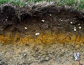
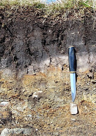
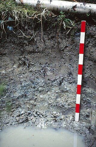
A soil horizon is a layer parallel to the soil surface whose physical, chemical and biological characteristics differ from the layers above and beneath. Horizons are defined in many cases by obvious physical features, mainly colour and texture. These may be described both in absolute terms and in terms relative to the surrounding material, i.e. 'coarser' or 'sandier' than the horizons above and below.
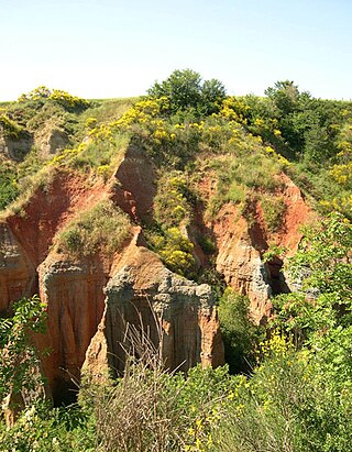
In geoscience, paleosol is an ancient soil that formed in the past. The definition of the term in geology and paleontology is slightly different from its use in soil science.

The World Reference Base for Soil Resources (WRB) is an international soil classification system for naming soils and creating legends for soil maps. The currently valid version is the fourth edition 2022. It is edited by a working group of the International Union of Soil Sciences (IUSS).

Pedalfer is composed of aluminum and iron oxides. It is a subdivision of the zonal soil order comprising a large group of soils in which sesquioxides increase relative to silica during soil formation. Pedalfers usually occur in humid areas. It is not used in the current United States system of soil classification but the term commonly shows up in college geology texts.

Soil morphology is the branch of soil science dedicated to the technical description of soil, particularly physical properties including texture, color, structure, and consistence. Morphological evaluations of soil are typically performed in the field on a soil profile containing multiple horizons.
The 1938 soil taxonomy divided soils into three orders dependent on dominant soil forming factors.
Bulk soil is soil outside the rhizosphere that is not penetrated by plant roots. The bulk soil is like an ecosystem, it is made up of many things such as: nutrients, ions, soil particles, and root exudates. There are many different interactions that occur between all the members of the bulk soil. Natural organic compounds are much lower in bulk soil than in the rhizosphere. Furthermore, bulk soil inhabitants are generally smaller than identical species in the rhizosphere. The main two aspects of bulk soil are its chemistry and microbial community composition.

A Planosol in the World Reference Base for Soil Resources is a soil with a light-coloured, coarse-textured, surface horizon that shows signs of periodic water stagnation and abruptly overlies a dense, slowly permeable subsoil with significantly more clay than the surface horizon. In the US Soil Classification of 1938 used the name Planosols, whereas its successor, the USDA soil taxonomy, includes most Planosols in the Great Groups Albaqualfs, Albaquults and Argialbolls.
A Stagnosol in the World Reference Base for Soil Resources (WRB) is soil with strong mottling of the soil profile due to redox processes caused by stagnating surface water.
An Alisol is a Reference Soil Group of the World Reference Base for Soil Resources (WRB).
The soil biomantle can be described and defined in several ways. Most simply, the soil biomantle is the organic-rich bioturbated upper part of the soil, including the topsoil where most biota live, reproduce, die, and become assimilated. The biomantle is thus the upper zone of soil that is predominantly a product of organic activity and the area where bioturbation is a dominant process.
A stone line is a three-dimensional subsurface layer, or ‘carpet,’ of stones evident as a ‘line of stones’ in natural exposures such as soils, road cuts, and trenches. Stone lines that are more than one stone thick have been called ‘stone zones’. Stone lines and stone zones are known to occur in soils, paleosols, and in non-soil geologic-stratigraphic sequences. Where present in stratigraphic sequences, if the units were deposited by running water, the stones are usually imbricated. This is strong evidence that such stone lines are geogenic. On the other hand, a stone line that is present in a soil or a paleosol is invariable non-imbricated and follows (mimics) the surface topography of the soil, or the paleosurface of a paleosol. This is strong evidence that such stone lines are pedogenic, and produced by soil forming processes. As it turns out, experience has shown that most stone lines are indeed associated with soils and paleosols, and most are consequently assumed to be pedogenic. How stone lines form, whether geogenically by geologic processes or pedogenically by soil forming processes is invariably a matter of interpretation. And whether the interpretation is geogenic or pedogenic often reflects the background and training of the interpreter.
The Polish Soil Classification is a soil classification system used to describe, classify and organize the knowledge about soils in Poland.
