
The Himalayas, or Himalaya, is a mountain range in Asia, separating the plains of the Indian subcontinent from the Tibetan Plateau.

Thimphu is the capital and largest city of Bhutan. It is situated in the western central part of Bhutan, and the surrounding valley is one of Bhutan's dzongkhags, the Thimphu District. The ancient capital city of Punakha was replaced by Thimphu as capital in 1955, and in 1961 Thimphu was declared as the capital of the Kingdom of Bhutan by the 3rd Druk Gyalpo Jigme Dorji Wangchuck.

Bhutan is a sovereign country at the crossroads of East Asia and South Asia, located towards the eastern extreme of the Himalayas mountain range. It is fairly evenly sandwiched between the sovereign territory of two nations: first, the People's Republic of China (PRC) on the north and northwest. There are approximately 477 kilometres of border with the country's Tibet Autonomous Region (TAR), or simply Tibet. The second nation is the Republic of India on the south, southwest, and east; there are approximately 659 kilometres with the states of Arunachal Pradesh, Assam, West Bengal, and Sikkim, in clockwise order from the kingdom. Bhutan's total borders amount to approximately 1,139 kilometres. The Republic of Nepal to the west, the India to the south, and the Union of Myanmar to the southeast are other close neighbours; the former two are separated by only very small stretches of Indian territory.

Manaslu is the eighth-highest mountain in the world at 8,163 metres (26,781 ft) above sea level. It is in the Mansiri Himal, part of the Nepalese Himalayas, in the west-central part of Nepal. The name Manaslu means "mountain of the spirit" and is derived from the Sanskrit word manasa, meaning "intellect" or "soul". Manaslu was first climbed on May 9, 1956, by Toshio Imanishi and Gyalzen Norbu, members of a Japanese expedition. It is said that, given the many unsuccessful attempts by the British to climb Everest before Nepali Tenzing Norgay and New Zealander Edmund Hillary, "just as the British consider Everest their mountain, Manaslu has always been a Japanese mountain".

Rolwāling Valley , knows as a (Gaurishankar) rural municipality, is a section of the Himalayas in east-central Nepal along the Tibet border. Rolwaling Himal includes Melungtse 7181m and Melungtse II 7023m inside Tibet and Gaurishankar 7134m on the Nepal border with some 50 additional peaks over 6000m, all extending from the Nangpa La pass where the Mahalangur section begins, southwest to the Tamakosi River. The Labuche Himal section rises beyond the Tamakosi to the northwest. Rolwaling Himal is bounded on the south by the Rolwaling Valley which contain several small sherpa villages Tasi Nam, Simigau and Beding under rolwaling valley, Tasi Nam is the largest town of the area. From Kathmandu five to six days are to reach Namche Bazaar around 10 days to mount Everest base camp, which have to Tasilapcha pass. Visitors can trek to Everest base camp by crossing Tasilapcha, fly from Kathmandu to Lukla or walk from kharikhola.
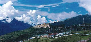
Tawang is a town and administrative headquarter of Tawang district in the Indian state of Arunachal Pradesh. The town was once the capital of the Tawang Tract, which is now divided into the Tawang district and the West Kameng district. Tawang continues as the headquarters of the former. Tawang is the number one tourist destination of Arunachal Pradesh.

There are two base camps on Mount Everest, on opposite sides of the mountains: South Base Camp is in Nepal at an altitude of 5,364 metres (17,598 ft), while North Base Camp is in China at 5,150 metres (16,900 ft).
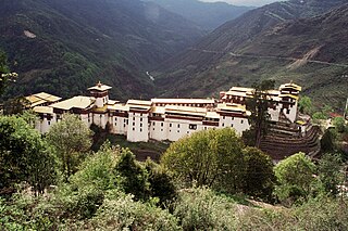
Bhutanese architecture consists of Dzong and everyday varieties. Dzongs in Bhutan were built as fortresses and have served as religious and administrative centers since the 17th century. Secular lordly houses emerged as a distinct style in the late 19th century, during a period of relative peace in Bhutan. Throughout its history, Bhutan has mainly followed the Tibetan tradition of Buddhist architecture.

Limi Valley is a high-altitude valley that forms the northernmost part of the Humla District of north-western Nepal. To its north, the Limi valley borders the Purang County of Tibet, China.

Mount Pandim is a Himalayan mountain located in Sikkim, India. It has an elevation of 6,691 m (21,952 ft) above sea level.

Paro Taktsang, is a sacred Vajrayana Himalayan Buddhist site located in the cliffside of the upper Paro valley in Bhutan. It is one of thirteen Tiger's Nest caves in historical Tibet in which Padmasambhava practiced and taught Vajrayana.
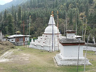
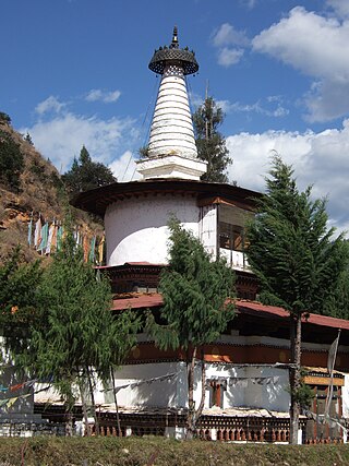
Chendebji Chorten is a stupa in Bhutan, located 41 kilometres (25 mi) west of Trongsa at 2,430 metres (7,970 ft) in elevation.
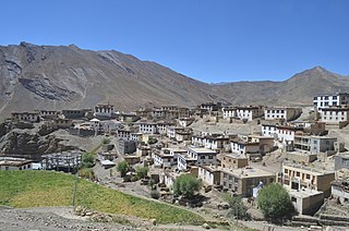
Kibber, also Kibber Khas and Khyipur, is a village high in the Spiti Valley in the Himalayas at 4,270 m (14,010 ft) in Himachal Pradesh in northern India. It contains a monastery and is a base for visiting the Kibber Wildlife Sanctuary. It is located 19 km (12 mi) from Kaza and a bus service connects them in the summer months. Agriculture forms the backbone of the local economy and lush green fields are abundant. It is the base for visitors to the Kibber Wildlife Sanctuary, home to about 30 snow leopards. Treks to neaby peaks and to a high pass in the Zanskar range between Spiti and Ladakh start from Kibber.

Alchi Monastery or Alchi Gompa is a Tibetan Buddhist monastery, known more as a monastic complex (chos-'khor) of temples in Alchi village in the Leh District, under the Ladakh Autonomous Hill Development Council of the Ladakh Union Territory. The complex comprises four separate settlements in the Alchi village in the lower Ladakh region with monuments dated to different periods. Of these four hamlets, Alchi monastery is said to be the oldest and most famous. It is administered by the Likir Monastery.
Jangtsa Dumgtseg Lhakhang[zlum brtshegs lha khang] is a Buddhist temple in western Bhutan. The temple is notable as it is in the form of a chorten, very rare in Bhutan. It is located on the edge of a hill between the Paro valley and the Dopchari valley, across the bridge from Paro. The Buddhist iconography depicted in the Chorten is considered a unique repository of the Drukpa Kagyu school.

The Great Himalaya Trail is a route across the Himalayas from east to west. The original concept was to establish a single long distance trekking trail from the east end to the west end of Nepal that includes a total of roughly 1,700 kilometres (1,100 mi) of path. There is a proposed trail of more than 4,500 kilometres (2,800 mi) stretching the length of the Greater Himalaya range from Nanga Parbat in Pakistan to Namche Barwa in Tibet thus passing through, India, Nepal, Bhutan and Tibet. Although an actual continuous route is currently only a concept, if completed it would be the longest and highest alpine hiking track in the world.
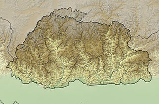
The mountains of Bhutan are some of the most prominent natural geographic features of the kingdom. Located on the southern end of the Eastern Himalaya, Bhutan has one of the most rugged mountain terrains in the world, whose elevations range from 160 metres (520 ft) to more than 7,000 metres (23,000 ft) above sea level, in some cases within distances of less than 100 kilometres (62 mi) of each other. Bhutan's highest peak, at 7,570 metres (24,840 ft) above sea level, is north-central Gangkhar Puensum, close to the border with Tibet; the third highest peak, Jomolhari, overlooking the Chumbi Valley in the west, is 7,314 metres (23,996 ft) above sea level; nineteen other peaks exceed 7,000 metres (23,000 ft). Weather is extreme in the mountains: the high peaks have perpetual snow, and the lesser mountains and hewn gorges have high winds all year round, making them barren brown wind tunnels in summer, and frozen wastelands in winter. The blizzards generated in the north each winter often drift southward into the central highlands.

The Dochu La( Dochu Pass, la means pass in Dzongkha) is a mountain pass in the snow covered Himalayas within Bhutan on the road from Thimphu to Punakha where 108 memorial chortens or stupas known as "Druk Wangyal Chortens" have been built by Ashi Dorji Wangmo Wangchuk, the eldest Queen Mother. Apart from the chortens there is a monastery called the Druk Wangyal Lhakhang (temple), built in honour of the fourth Druk Gyalpo, Jigme Singye Wangchuck; the open grounds in its front yard is a venue for the annual Dochula Druk Wangyel Festival. The pass with 108 memorial chortens is adjacent to the country's first Royal Botanical Park.

Lawa La is a high-mountain motorable pass located in Bhutan.
 Chorten at Pele La Pass, Central Bhutan, c. March 2023
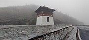 Chorten at Pele La Pass, Central Bhutan, c. March 2023
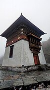 Chorten at Pele La Pass, Central Bhutan, c. March 2023
 Biological Corridor 08, Pele La Pass, Central Bhutan, c. March 2023


