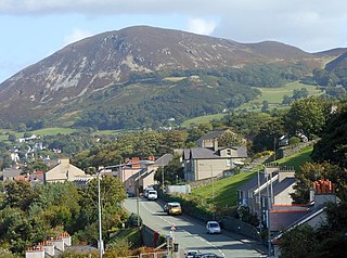
Penmaenmawr is a town and community in Conwy County Borough, Wales, which was formerly in the parish of Dwygyfylchi and the traditional county of Caernarfonshire. It is on the North Wales coast between Conwy and Llanfairfechan and was an important quarrying town, though quarrying is no longer a major employer. The population of the community was 4,353 in 2011, including Dwygyfylchi and Capelulo. The town itself having a population of 2,868 (2011).

The Cambrian Mountains are a series of mountain ranges in Wales. The term Cambrian Mountains used to apply to most of the upland of Wales. Since the 1950s, its application has become increasingly localised to the geographically homogeneous Mid Wales uplands, known in Welsh as Elenydd, which extend from Pumlumon to Radnor Forest in the east and Mynydd Mallaen to the south. This barren and sparsely populated 'wilderness' has been referred to as the Desert of Wales. The area includes the sources of the River Severn and River Wye and was unsuccessfully proposed as a national park in the 1960s and 1970s. The highest point of the range is Plynlimon, at 2,467 feet (752 m).

The Black Mountains are a group of hills spread across parts of Powys and Monmouthshire in southeast Wales, and extending across the England–Wales border into Herefordshire. They are the easternmost of the four ranges of hills that comprise the Bannau Brycheiniog National Park, and are frequently confused with the westernmost, which is known as the Black Mountain. The Black Mountains may be roughly defined as those hills contained within a triangle defined by the towns of Abergavenny in the southeast, Hay-on-Wye in the north and the village of Llangors in the west. Other gateway towns to the Black Mountains include Talgarth and Crickhowell. The range of hills is well known to walkers and ramblers for the ease of access and views from the many ridge trails, such as that on the Black Hill (Herefordshire) at the eastern edge of the massif. The range includes the highest public road in Wales at Gospel Pass, and the highest point in southern England at Black Mountain.

Waun Fach is, with a summit height of 811 metres (2,661 ft), the highest mountain in the Black Mountains in south-eastern Wales. It is one of the three Marilyns over 600 m that make up the range, the others being Black Mountain and Mynydd Troed. To the north Rhos Fawr and the Radnor Forest can be seen. It is the third highest mountain in Britain south of Snowdonia. It is situated at the head of the Grwyne Fechan valley, above and to the west of the Grwyne Fawr reservoir. It has an undistinguished rounded summit. The nearby tops on the ridge, Pen Trumau and Pen y Gadair Fawr, although lower, are very much more recognisable.

Merthyr Mawr is a village and community in Bridgend, Wales. The village is about 2+1⁄2 miles from the centre of Bridgend town. The population of the community at the 2011 census was 267. The community occupies the area west of the Ewenny River, between Bridgend and Porthcawl. It takes in the settlement of Tythegston and a stretch of coastal sand dunes known as Merthyr Mawr Warren. It is in the historic county of Glamorgan.

The Moelwynion are a group of mountains in central Snowdonia. They extend from the north-east of Porthmadog to Moel Siabod, the highest of the group. The name derives from the names of two of the largest mountains in the group, Moelwyn Mawr and Moelwyn Bach, 770m and 710m, respectively. Moel Siabod, to the north, is the highest at 872m.

Gwaun y Llwyni is a subsidiary summit of Aran Fawddwy in southern Snowdonia, Wales. It forms a part of the Aran mountain range.

Pen y Gadair Fawr is an 800 metres (2,625 ft) high subsidiary summit of Waun Fach and the second highest peak in the Black Mountains in south-eastern Wales. Marked by a medium-sized cairn, it is a much more distinguished top than its parent 1.5 km to the northwest. Its 658 metres (2,159 ft) high top Pen Twyn Mawr is about 2 km to the southeast.
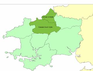
Cemais Is Nyfer was a mediaeval commote in the Dyfed cantref of Cemais, Wales. It consisted of the territory between the rivers Nyfer and Teifi, and comprised the parishes of Eglwyswrw, Monington, St Dogmaels, Llanfair-Nant-Gwyn, Llantood, Moylgrove and Bayvil, and parts of Nevern and Meline in what is now Pembrokeshire. Its area was about 100 km2 and its civil and ecclesiastical headquarters were at Nevern.

The Beacons Way is a waymarked long distance footpath in the Brecon Beacons National Park, Wales. It is a linear route which runs for 99 miles (159 km) east to west through the National Park, and passes many of the most important landmarks and mountain peaks in the mountain range. It also includes a few of the towns in the park as well as popular attractions such as Carreg Cennen Castle near Llandeilo at the western end of the path.

Pen Cerrig-calch is a subsidiary summit of Waun Fach in the Black Mountains in the Brecon Beacons National Park in southern Powys, Wales. Its summit, at a height of 701 m (2,300 ft), is marked by a trig point. The peak sits high above the River Usk valley as it narrows above the small town of Crickhowell. The views from here are wide-ranging and extend as far as the Beacons themselves to the west. A ridge runs off to the northwest and the shoulder of Pen Gloch-y-pibwr then turns north to the secondary top of Pen Allt-mawr whose peak at 719m is also crowned by a trig point.

Moelwyn Mawr North Ridge Top is a top of Moelwyn Mawr in Snowdonia, North Wales and forms part of the Moelwynion. From its summit, which directly overlooks Bwlch Rhosydd, can be seen Cnicht, Allt-fawr and Moel-yr-hydd. A recently discovered 'top' has only received attention from Nuttall baggers.

Mynydd Illtud is an extensive area of common land near Libanus, Powys, Wales, located in the Brecon Beacons National Park and some three miles south-west of Brecon. The common is an undulating plateau lying between 330 and 370 metres above sea level. Its highest points are 381 metres (1,250 ft) at Allt Lom and 367 metres (1,204 ft) at Twyn y Gaer trig point overlooking the valley of the River Usk. Twyn y Gaer is the site of an Iron Age hill fort.

Allt yr Esgair is a hill in the Brecon Beacons National Park in Powys, Wales. It is commonly referred to locally as simply 'The Allt'. The Welsh name signifies 'wooded slope of the ridge'. It takes the form of a northwest-southeast aligned ridge which rises to a height of 393m and which overlooks the valley of the River Usk to the west and south. To the northeast are panoramic views across Llangorse Lake to the Black Mountains There is a viewfinder on the summit erected as a monument to Eirene Lloyd White, Baroness White of Rhymney. It is a Marilyn with a prominence of 199 metres.

Pen Twyn Mawr is a top of Pen y Gadair Fawr in the Black Mountains in south-eastern Wales. It lies on one of the many south ridges of Waun Fach.

Pen Allt-mawr is a 719 metres (2,359 ft) high subsidiary summit of Waun Fach and the third highest peak in the Black Mountains in south-eastern Wales. A very recognisable and prominent peak of the Black Mountains, it lies near the end of the more westerly of Waun Fach's two broad southern ridges. Its top Pen Twyn Glas is to the north, while its close neighbour Pen Cerrig-calch is to the south. A prominent spur 1 km to the SSW of the summit is known as Pen Gloch-y-pibwr. The stepped Bryniog ridge curves southward from this point.

Rhos Dirion is a top of Waun Fach in the Black Mountains in south-eastern Wales. It is the highest point on the Rhos Dirion - Chwarel y Fan ridge.

Mynydd Llysiau is a subsidiary summit of Waun Fach in the Black Mountains in south-eastern Wales. It lies halfway between Waun Fach and Pen Allt-mawr. It is a distinguished summit with a steep eastern face.
Mynydd Troed is a hill in the Black Mountains of the Brecon Beacons National Park in Powys, south Wales. Its name literally translates to "Foot Mountain," based how it appears when viewed from the Allt Mawr ridge.
