Pencader Tunnel

Last updated

Northern end Northern end of Pencader Tunnel - geograph.org.uk - 1101562.jpg
Northern end

Pencader Tunnel is an abandoned railway tunnel on the old trackbed of the Carmarthen to Aberystwyth main line in south-west Wales. It was originally bored for the Llanpumsaint-Pencader section of the Carmarthen & Cardigan (C&C) Railway.

It is approximately 988 yards (903 m) long (just over half-a-mile), making it the longest tunnel in West Wales and is bored through Ordovician shales. It is single-track and built to the C&C's adopted broad gauge dimensions, as opposed to the smaller standard gauge used on Britain's railways today. It is also known as alternatively Alltwalis Tunnel and Dolgran Tunnel to local villagers. [1]

History

From the first proposals of the Carmarthen and Cardigan railway it was known that an expensive and long tunnel would be needed to take the line between the valleys of Skanda Vale (in which Llanpumpsaint station resided) and Dolgran, under the Brechfa Forest watershed. Several separate Engineers surveyed the line, including Isambard Kingdom Brunel, with varying schemes. Brunel proposed a dead-straight tunnel to connect the valleys, though after reworking, the final design was longer in order to ease the gradients.

As built, the tunnel was approximately 988 yards (903 m) long, [2] curving slightly from the southern portal in Skanda Vale, running straight for most of its length and then curving for the final third into Dolgran. The digging would require two construction shafts which could then be used for ventilation. Construction started in the spring of 1857 to bore the tunnel at the same time as work began on the first stage of the railway line in the town of Carmarthen.

During construction in 1859, the C&C railway attempted to switch from broad gauge to standard gauge, which would have meant all railway infrastructure (including the tunnel), could be built to smaller (and thus cheaper) dimensions. Such a change would require the approval of the British Parliament and pressurisation on the company by the South Wales Railway, a broad gauge line in the area which did not want the rival standard gauge making an incursion on its territory, meant the application to Parliament never occurred.

Digging initially proceeded from four sites - at either end and from the bottom of the first ventilation shaft sunk. Once the second shaft was finished, digging also commenced from there, though this had been abandoned by May 1860 according to a report which stated that 576 yards (527 m) had been dug by this time, approximately two-thirds of the full length. Work was expected to be finished by December 1860/January 1861.

As it stood, the tunnel was only 'finished' in March 1861 although, at the time, it was exposed rock without a brick lining and required further work to complete it. The long approach cuttings were also unfinished at this time. During construction of the tunnel, many of the horses used to haul away excavated rock died from disease and were buried in the field surrounding the northern of the two shafts. The same field also has grassed-over rubble remaining from cottages built by the construction navvies. Much of the spoil excavated was used to build embankments north and south of the tunnel but large spoil heaps can be seen on the hillsides around both ventilation shafts.

Further delays were caused by the original contractor for the railway, Jays of London, abandoning the construction of the line in autumn 1861. By November, however, another contractor, Holdens, had taken over the task. Work was focused on finishing several miles of railway either side of the tunnel and, although easy to the north, to the south, heavy engineering of cuttings and embankments slowed the work.

Track is known to have been laid through the tunnel at some point prior to December 1863, as a company report mentions an accident in that month on a ballast train en route to Pencader, beyond the tunnel. Official government inspection was carried out in January 1864 and the tunnel opened with the rest of the Llanpumsaint-Pencader section of the line on 3 June 1864. [3] At the time, the tunnel was still unlined and a watchman was employed to inspect the tunnel for any rockfalls, until it was eventually lined with brick some years later.

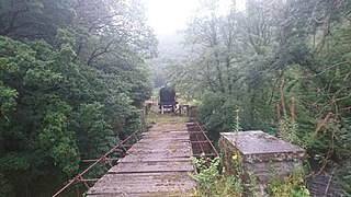
By the time the tunnel was finished, having taken four years to build and a further three to complete the railway approaches to it, the project had crippled the finances of the Carmarthen to Cardigan Railway, which soon went into receivership. After the railway was closed to freight traffic in October 1973, and the track was removed two years later. [4] [5] The tunnel was not demolished and remains in place. There have been proposals to reconnect the railway between Aberystwyth and Carmarthen which would use Pencader Tunnel. [6]

Related Research Articles

<span class="mw-page-title-main">Box Tunnel</span> Railway tunnel in western England

Box Tunnel passes through Box Hill on the Great Western Main Line (GWML) between Bath and Chippenham. The 1.83-mile (2.95 km) tunnel was the world's longest railway tunnel when it was completed in 1841.

<span class="mw-page-title-main">Gwili Railway</span> Heritage railway in Carmarthenshire, Wales

The Gwili Railway is a Welsh heritage railway, that operates a preserved standard gauge railway line from the site of Abergwili Junction in southwest Wales along a four-and-a-half-mile (7.2 km) section of the former Carmarthen to Aberystwyth line. The original railway closed in 1965, with the track being lifted in 1975.

<span class="mw-page-title-main">Carmarthen railway station</span> Railway station in Carmarthenshire, Wales

Carmarthen railway station is on the West Wales Line serving the town of Carmarthen, Wales, south of the River Towy, 245 miles 55 chains (395.4 km) from the zero point at London Paddington, measured via Stroud. The station is operated by Transport for Wales. Great Western Railway also run a limited service between Carmarthen and London Paddington, usually six trains each way daily with an additional return service to Bristol Parkway.

<span class="mw-page-title-main">Pencader, Carmarthenshire</span> Village in Carmarthenshire, Wales

Pencader is a small village in Carmarthenshire, Wales, in the community of Llanfihangel-ar-Arth. It is located around 3 miles (5 km) south-east of Llandysul and 6.5 miles (10 km) south-west of Llanybydder, in the valley of the Gwen brook, shortly before the confluence with the River Talog, to form the River Tyweli.

<span class="mw-page-title-main">Teifi Valley Railway</span> Heritage railway in west Wales

The Teifi Valley Railway is a 2 ft narrow gauge railway occupying a section of the former standard gauge Great Western Railway line between Llandysul and Newcastle Emlyn. After the closure of the former line by British Rail in 1973, a preservation group built and periodically extended a narrow-gauge railway along the route, westwards from Henllan, eventually operating a 3 kilometres (1.9 mi) long line as a tourist attraction.

<span class="mw-page-title-main">Carmarthen–Aberystwyth line</span> Former railway line in Wales

The Carmarthen–Aberystwyth line was originally a standard-gauge branch line of the Great Western Railway (GWR) in Wales, connecting Carmarthen and Aberystwyth.

The Carmarthen and Cardigan Railway was a 7 ft 14 in broad gauge railway line in Wales that was intended to connect Carmarthen on the South Wales Railway with Cardigan. In fact, it was unable to raise the necessary capital and was loss-making from the time of opening the first short section of its line in 1860, and it was in receivership for much of its life. It eventually reached Llandysul in 1864 but was not extended further during its independent existence.

<span class="mw-page-title-main">Llanpumsaint</span> Village and community in Carmarthenshire, Wales

Llanpumsaint is a village and community in Carmarthenshire, Wales. In the 2001 UK Census, Llanpumsaint community had a population of 595. It is not to be confused with Pumsaint, a small village some distance away on the River Cothi. The population increased in 2011 to 734, and thus the percentage of Welsh speakers declined.

The South Wales Railway was a main line railway which opened in stages from 1850, connecting the Great Western Railway from Gloucester to South Wales. It was constructed on the broad gauge. An original aspiration was to reach Fishguard to engender an Irish ferry transit and transatlantic trade, but the latter did not materialise for many years, and never became an important sector of the business. Neyland was the western terminus of the line until 1906.

<span class="mw-page-title-main">Pembroke and Tenby Railway</span>

The Pembroke and Tenby Railway was a locally promoted railway in Pembrokeshire, Wales. It was built by local supporters and opened in 1863. The line, now known as the Pembroke Dock branch line, remains in use at the present day.

<span class="mw-page-title-main">James Szlumper</span> English civil engineer

Sir James Weeks Szlumper JP DL was an English civil engineer. He was Chief Engineer on a number of key railway engineering projects in the Victorian era.

The Manchester and Milford Railway was a Welsh railway company, intended to connect Manchester and the industrial areas of North West England with a deep-water port on Milford Haven, giving an alternative to the Port of Liverpool.

Newcastle Emlyn was a railway station terminus in the town of Newcastle Emlyn, West Wales, on the proposed broad gauge Teifi Valley line of the Carmarthen and Cardigan Railway.

The Lampeter, Aberayron and New Quay Light Railway was an independent branch line railway in south west Wales. It connected Aberayron to the former Manchester and Milford Railway line at Lampeter; New Quay was never reached.

<span class="mw-page-title-main">Llangurig branch</span> Railway line in the UK

The Llangurig branch was a part of a proposed scheme by the Manchester and Milford Railway (M&MR) to connect industrialised Northwest England with the West Wales deep water port of Milford Haven. After various financial and construction difficulties, the 1.5 miles (2.4 km) of the Llangurig branch is noted as being the shortest lived working branch line in the United Kingdom, receiving only one train.

Pentrecourt Platform was a minor railway station near the village of Pentrecwrt, West Wales, on the originally broad gauge Teifi Valley line of the Carmarthen and Cardigan Railway. The halt opened in 1912 to serve the old Alltycefn Woollen Mill and the village, lying some 5 miles and 21 chains from the junction at Pencader and situated between the villages of Llandysul and Henllan.

<span class="mw-page-title-main">Llandyssul railway station</span> Former railway station in Wales

Llandyssul was a railway station near the village of Llandysul, West Wales, on the originally broad gauge Teifi Valley line of the Carmarthen and Cardigan Railway.

<span class="mw-page-title-main">Conwil railway station</span> Disused railway station in Wales

Conwil was a railway station near the village of Cynwyl Elfed in Carmarthenshire, Wales, serving the hamlet and the rural locale. It was once a thriving railway station, transporting both passenger traffic and locally produced goods, including wool, livestock, milk and timber.

<span class="mw-page-title-main">Cockett railway station</span> Former railway station in Wales

Cockett railway station was a former station on the West Wales Line from Swansea to Gowerton and onwards to Llanelli.

The Great Western Railway was a railway company that was dominant in West Wales, in the United Kingdom.

References

  1. "Railway tunnel lengths, G-P". railwaycodes.org.uk. Retrieved 1 February 2024.
  2. "Pencader Tunnel". forgottenrelics.org. Retrieved 1 February 2024.
  3. Page, James (1988). Forgotten Railways volume 8: South Wales. Newton Abbot: David & Charles. p. 194. ISBN   0-9465-3744-5.
  4. Baughan, Peter E. (1980). North and Mid Wales. Newton Abbot: David & Charles. p. 233. ISBN   0-7153-7850-3.
  5. Smith, Claire (13 April 2021). "West Wales rail lines turns to crowdfunding in bid to reopen axed route". New Civil Engineer. Retrieved 1 February 2024.
  6. "A new strategic rail corridor for West Wales" (PDF). business.senedd.wales. September 2020. p. 20. Retrieved 1 February 2024.


Map all coordinates using: OpenStreetMap

51°58′45″N4°18′09″W / 51.9793°N 4.3026°W / 51.9793; -4.3026