
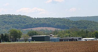
State College Regional Airport, is a public airport in Benner Township, Centre County, Pennsylvania, serving State College and Bellefonte. The airport covers 1,105 acres and has one active runway.
Rostraver Airport is a public use airport in Westmoreland County, Pennsylvania, United States.

Doylestown Airport is a public airport in Bucks County, Pennsylvania, owned by the Bucks County Airport Authority (BCAA). It is two nautical miles north of Doylestown, Pennsylvania and has a single fixed-base operator, Leading Edge Aviation, Civil Air Patrol squadron 907, flight training, and aircraft rentals.
Quakertown Airport is a public airport in Bucks County, Pennsylvania, owned by the Bucks County Airport Authority. It is two miles west of Quakertown, Pennsylvania and was dedicated on 22 January 1965. It is home to the Civil Air Patrol Squadron 904.
Heritage Field is a public use airport in Montgomery County, Pennsylvania, United States. It is located three nautical miles (6 km) east of Pottstown, in Limerick Township. The airport is privately owned by Limerick Aviation LP.

Brandywine Airport is a public-use general aviation airport in West Goshen Township, Pennsylvania, United States, three miles northeast of West Chester. It is designated as a reliever airport and a regional general aviation airport by the FAA. It is privately owned by the New Brandywine Airport Club Inc, with a single fixed-base operator, aircraft repair, as well as flight training in both fixed-wing and rotary aircraft. The American Helicopter Museum and Education Center is located adjacent to the airport, with taxiway access.
Beaver County Airport or is a county-owned public airport three miles northwest of Beaver Falls, in Beaver County, Pennsylvania.
Pittsburgh Northeast Airport is a privately owned, public use airport in Allegheny County, Pennsylvania, United States. The airport is located 12 nautical miles north-northeast of the central business district of Pittsburgh, in West Deer Township. The airport is located a few miles north of Pittsburgh Mills shopping mall.
Lakehill Airport, is a privately owned airport near Mars, Pennsylvania, U.S., part of the Pittsburgh metropolitan area. It is the smallest of the three airports located in Butler County. The other two are the Butler County Airport, and the Butler Farm Show Airport.

Mid-State Regional Airport is a small airport in Rush Township, Centre County in Pennsylvania, between Black Moshannon State Park to the east and Moshannon State Forest.
Penn Yan Airport is a county-owned public-use airport located one nautical mile (1.8 km) south of the central business district of the Penn Yan, a village in Yates County, New York, United States. It is also known as Penn Yan - Yates County Airport.
New Castle Municipal Airport is a small municipal airport located in Union Township, Lawrence County, Pennsylvania serving Lawrence County, Pennsylvania, part of the Pittsburgh metropolitan area. Union Township is an outskirt of New Castle, Pennsylvania hence the name. The airport is located four nautical miles northwest of the central business district of New Castle. The airport is a public-owned airport and is controlled by the Lawrence County Airport Authority.
The Greenville Municipal Airport is a public use airport which is located three nautical miles (6 km) north of the central business district of Greenville, a borough in Mercer County, Pennsylvania, United States. It is owned by the Borough of Greenville.
The Greene County Airport is a county-owned, public-use airport in Franklin Township, Greene County, Pennsylvania, United States. It is located two nautical miles (4 km) east of the central business district of Waynesburg, Pennsylvania. This airport was included in the National Plan of Integrated Airport Systems for 2009–2013, which categorized it as a general aviation facility.
Penn Valley Airport is a public airport a mile north of Selinsgrove, a borough in Snyder County, Pennsylvania. It is owned by the Penn Valley Airport Authority. The National Plan of Integrated Airport Systems for 2011–2015 categorized it as a general aviation facility.
McVille Airport is a privately owned, public use airport located six nautical miles northeast of the central business district of Freeport, a borough in Armstrong County, Pennsylvania, United States.
Wellsboro Johnston Airport is a public non-towered general aviation Airport that is located 4 miles SW of and serves Wellsboro, Pennsylvania.

Bellefonte Airport is a privately owned and operated airport in Bellefonte, Pennsylvania. It serves as a general aviation airport in the State College metropolitan area.

