Centre Hall, Pennsylvania

Last updated

Centre Hall, Pennsylvania
St Luke Lutheran Centre Hall PA.jpg
St. Luke Lutheran Church on Pennsylvania Avenue in Centre Hall
Motto: 
In the Centre of it all!
Centre County Pennsylvania Incorporated and Unincorporated areas Centre Hall Highlighted.svg
Location of Centre Hall in Centre County, Pennsylvania.
Map of Pennsylvania highlighting Centre County.svg
Map showing Centre County in Pennsylvania
USA Pennsylvania location map.svg
Red pog.svg
Centre Hall
Location within the U.S. state of Pennsylvania
Usa edcp location map.svg
Red pog.svg
Centre Hall
Centre Hall (the United States)
Coordinates: 40°50′39″N77°41′05″W / 40.84417°N 77.68472°W / 40.84417; -77.68472
Country United States
State Pennsylvania
County Centre
Settled1847
Incorporated (borough)1881
Government
  MayorLeDon Young
Area
[1]
  Total
0.62 sq mi (1.59 km2)
  Land0.62 sq mi (1.59 km2)
  Water0.00 sq mi (0.00 km2)
Elevation
1,319 ft (402 m)
Population
 (2020) [2]
  Total
1,268
  Density2,058.44/sq mi (795.40/km2)
Time zone Eastern (EST)
  Summer (DST)EDT
ZIP code
16828 [3]
Area code 814
FIPS code 42-12376
Website Borough website

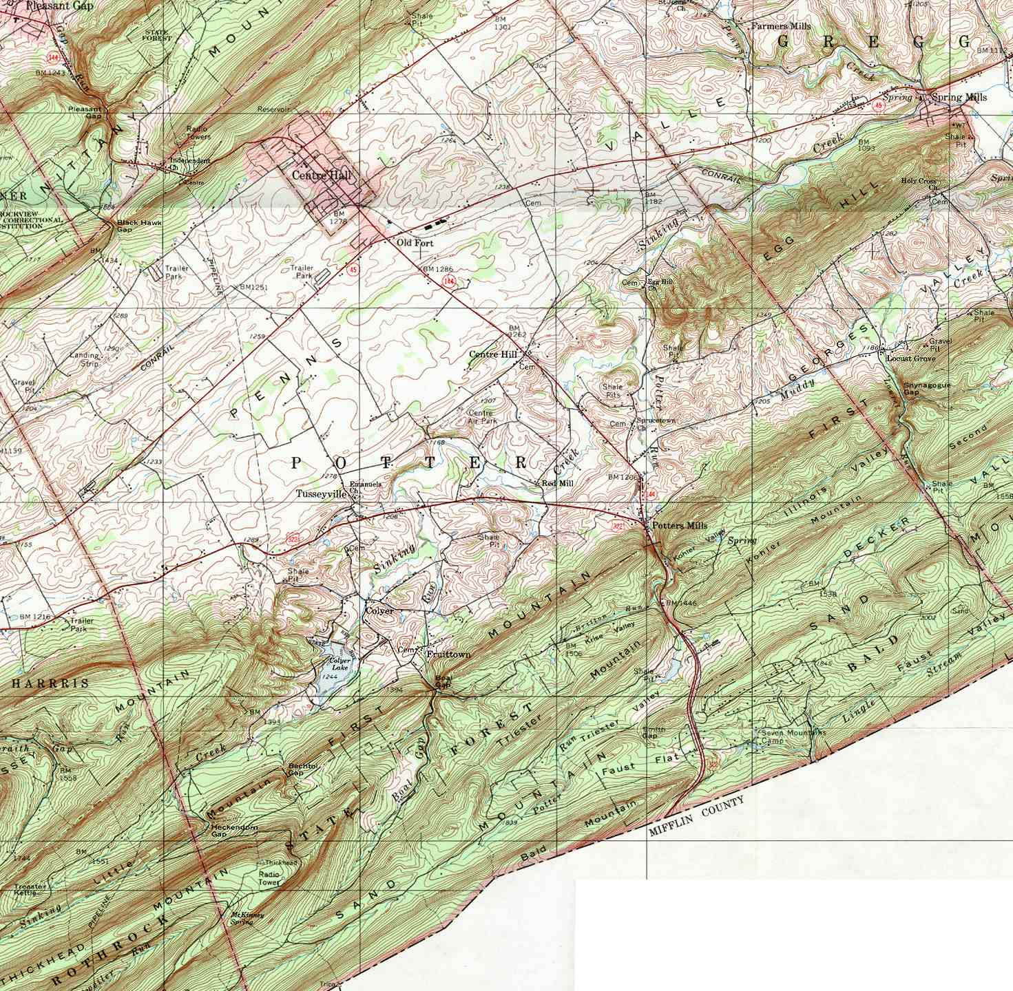
Centre Hall is a borough in Centre County, Pennsylvania, United States. It is located in Penns Valley and is part of the State College, Pennsylvania Metropolitan Statistical Area. The population was 1,265 at the 2010 census, which is a 17.2% increase from the 2000 census.

Contents

Centre Hall was so named on account of its location near the geographical center of Penns Valley. [4]

Geography

Centre Hall is located at 40°50′39″N77°41′5″W / 40.84417°N 77.68472°W / 40.84417; -77.68472 (40.844287, -77.684615). [5]

According to the United States Census Bureau, the borough has a total area of 0.6 square miles (1.6 km2), all land.

Events

Centre Hall Reformed Church Centre Hall PA Reformed PHS116.jpg
Centre Hall Reformed Church

Centre Hall hosts the Centre County Grange Encampment and Fair, known to most as the "Grange Fair". The Fair attracts tens of thousands of people during its run, and takes place during the last full Thursday-to-Thursday week in August annually. It is one of the few remaining tenting fairs in the United States, with nearly a thousand "army-style" tents laid in rows throughout the grounds. In 1874, Leonard Rhone, a local farmer and activist, urged that members of the local Granges that he had founded to invite their neighbors to a one-day Pic-Nic to introduce the Patrons of Husbandry organization for farm and rural families. With the exception of 1943, the Fair has been held every year since.

Demographics

Historical population
CensusPop.Note
1880 350
1890 44126.0%
1900 53721.8%
1910 500−6.9%
1920 5255.0%
1930 65825.3%
1940 73812.2%
1950 83413.0%
1960 1,10933.0%
1970 1,28215.6%
1980 1,233−3.8%
1990 1,203−2.4%
2000 1,079−10.3%
2010 1,26517.2%
2020 1,2680.2%
Sources: [6] [7] [8] [2]

At the 2010 census there were 1,265 people, 548 households, and 372 families residing in the borough. The population density was 2,054.2 inhabitants per square mile (793.1/km2). There were 574 housing units at an average density of 932.9 per square mile (360.2/km2). The racial makeup of the borough was 99.0% White, 0.1% Black or African American, 0.1% Native American, 0.2% Asian, 0.1% other, and 0.5% from two or more races. [7] There were 548 households, 26.6% had children under the age of 18 living with them, 56.0% were married couples living together, 3.3% had a male householder with no wife present, 8.6% had a female householder with no husband present, and 32.1% were non-families. 27.7% of households were made up of individuals, and 10.8% were one person aged 65 or older. The average household size was 2.31 and the average family size was 2.81.

In the borough the population was spread out, with 20.1% under the age of 18, 6.7% from 18 to 24, 26.2% from 25 to 44, 26.0% from 45 to 64, and 21.0% 65 or older. The median age was 43 years. For every 100 females there were 88.2 males. For every 100 females age 18 and over, there were 87.6 males.

The median household income was $50,556 and the median family income was $64,141. The per capita income for the borough was $25,298. About 4.7% of families and 6.0% of the population were below the poverty line, including 11.9% of those under age 18 and 1.9% of those age 65 or over.

Centre Airpark

Centre Airpark ( FAA LID : N16) is a small airport with a 3100 ft grass runway just southeast of Centre Hall. [9] Its use includes ultralight aircraft.

Related Research Articles

<span class="mw-page-title-main">Fairfield, Pennsylvania</span> Borough in Pennsylvania, United States

Fairfield is a borough in Adams County, Pennsylvania, United States. The population was 526 at the 2020 census.

<span class="mw-page-title-main">White Oak, Pennsylvania</span> Borough in Pennsylvania, United States

White Oak is a borough in Allegheny County, Pennsylvania, United States. The population was 7,630 at the 2020 census. It is a suburb of the Pittsburgh metropolitan area. White Oak was named for a stand of white oak trees near the original town site.

<span class="mw-page-title-main">Bedford, Pennsylvania</span> Borough in Pennsylvania, United States

Bedford is a borough, spa town, and the county seat of Bedford County in the U.S. state of Pennsylvania. It is located 102 miles (164 km) west of Harrisburg, the state capital, and 107 miles (172 km) east of Pittsburgh. Bedford's population was 2,865 at the 2020 census.

<span class="mw-page-title-main">Slippery Rock, Pennsylvania</span> Borough in Pennsylvania, United States

Slippery Rock is a borough in Butler County, Pennsylvania. The population was 3,081 at the 2020 census. Slippery Rock is included in the Greater Pittsburgh Region. The area is home to Slippery Rock University of Pennsylvania, partially in the borough limits, and attended by nearly 9,000 students as a member of the Pennsylvania State System of Higher Education.

<span class="mw-page-title-main">Howard, Pennsylvania</span> Borough in Pennsylvania, United States

Howard is a borough in Centre County, Pennsylvania, United States. It is part of the State College, Pennsylvania Metropolitan Statistical Area. The population was 720 at the 2010 census.

<span class="mw-page-title-main">Milesburg, Pennsylvania</span> Borough in Pennsylvania, United States

Milesburg is a borough in Centre County, Pennsylvania. It is part of the State College, Pennsylvania metropolitan statistical area. The population was 1,093 at the 2020 census.

<span class="mw-page-title-main">Millheim, Pennsylvania</span> Borough in Pennsylvania, United States

Millheim is a borough in Centre County, Pennsylvania, United States. It is part of the State College, Pennsylvania Metropolitan Statistical Area. The population was 904 at the 2010 census. The Millheim Historic District, which includes 176 contributing buildings, was listed on the National Register of Historic Places in 1986.

<span class="mw-page-title-main">Potter Township, Centre County, Pennsylvania</span> Township in Pennsylvania, United States

Potter Township is a township in Centre County, Pennsylvania, United States. It is part of Penns Valley and the State College, Pennsylvania Metropolitan Statistical Area. The population was 3,614 at the 2020 census. Communities in Potter Township include Black Hawk, Centre Hill, Colyer, Fruittown, Old Fort, Potter Mills, Red Mill, and Tusseyville.

<span class="mw-page-title-main">Rebersburg, Pennsylvania</span> Census-designated place in Pennsylvania, United States

Rebersburg is an unincorporated community and census-designated place (CDP) in Centre County, Pennsylvania, United States. Rebersburg is part of the State College, Pennsylvania Metropolitan Statistical Area. The population was 494 at the 2010 census and includes many Amish in the area.

<span class="mw-page-title-main">Snow Shoe, Pennsylvania</span> Borough in Pennsylvania, United States

Snow Shoe is a borough in Centre County, Pennsylvania, United States. It is part of the State College, Pennsylvania Metropolitan Statistical Area. The population was 765 at the 2010 census.

<span class="mw-page-title-main">Union Township, Centre County, Pennsylvania</span> Township in Pennsylvania, United States

Union Township is a township that is located in Centre County, Pennsylvania, United States. It is part of the State College, Pennsylvania Metropolitan Statistical Area.

<span class="mw-page-title-main">Unionville, Centre County, Pennsylvania</span> Borough in Pennsylvania, United States

Unionville is a borough in Centre County, Pennsylvania, United States. It is part of the Bald Eagle Valley and the State College, Pennsylvania Metropolitan Statistical Area. As of the 2010 census, the borough had a total population of 291.

<span class="mw-page-title-main">Kennett Square, Pennsylvania</span> Borough in Pennsylvania, United States

Kennett Square is a borough in Chester County, Pennsylvania, United States. As of the 2020 U.S. census, Kennett Square had a population of 5,943.

<span class="mw-page-title-main">Mill Hall, Pennsylvania</span> Borough in Pennsylvania, United States

Mill Hall is a borough in Clinton County, Pennsylvania, United States. The population was 1,613 at the 2010 census.

<span class="mw-page-title-main">Newburg, Cumberland County, Pennsylvania</span> Borough in Pennsylvania, United States

Newburg is a borough in Cumberland County, Pennsylvania, United States. The population was 336 at the 2010 census. It is part of the Harrisburg–Carlisle metropolitan statistical area.

<span class="mw-page-title-main">Port Royal, Pennsylvania</span> Borough in Pennsylvania, United States

Port Royal is a borough in Juniata County, Pennsylvania, United States. The population was 815 at the 2020 census.

<span class="mw-page-title-main">Myerstown, Pennsylvania</span> Borough in the United States

Myerstown is a borough located in Lebanon County, Pennsylvania. It is part of the Lebanon, Pennsylvania Metropolitan statistical area. The population was 3,103 at the 2020 census. It is home to over 100 businesses, including a Bayer manufacturing plant, a GAF manufacturing plant, Farmer Boy Ag, Stoneridge Towne Centre and Wengers of Myerstown. The Evangelical Seminary is located on South College Street.

<span class="mw-page-title-main">Matamoras, Pennsylvania</span> Borough in Pennsylvania, United States

Matamoras is a borough in Pike County, Pennsylvania, United States. The population was 2,362 at the 2020 census. It is the easternmost municipality of any kind in Pennsylvania. Matamoras is part of the New York–Newark–Jersey City, NY–NJ–PA Metropolitan Statistical Area, as well as the larger New York–Newark, NY–NJ–CT–PA Combined Statistical Area.

<span class="mw-page-title-main">Forksville, Pennsylvania</span> Borough in Pennsylvania, United States

Forksville is a borough in Sullivan County, Pennsylvania, United States. The population was 110 at the 2020 census. It is the home of the 150-year-old Forksville General Store, down the road from the Sullivan County Fairgrounds, and near Worlds End State Park. The name comes from the confluence of Little Loyalsock Creek and Loyalsock Creek within the borough.

<span class="mw-page-title-main">Mifflinburg, Pennsylvania</span> Borough in Pennsylvania, United States

Mifflinburg is a borough in Union County, located in the Susquehanna River Valley of central Pennsylvania, United States. In 1792, Mifflinburg was settled by Elias and Catharina Youngman and 8 other families, many of them German, and the village of Mifflinsburgh was formed. It was named for Thomas Mifflin, who was governor of Pennsylvania and first governor under the PA Constitution of 1790, and a signer of the U.S. Constitution. Youngmanstown was another name based upon common nemonclature only, but not officially. In 1827, Mifflinburg, a.k.a. Youngmanstown, and another town adjacent to the east named Greenville, a.k.a. Rhodestown,, were combined and incorporated into a borough. The first horse drawn buggy and carriage manufacturing company was established in 1845; and Mifflinburg would become the Buggy and carriage manufacturing capital of the United States in the late 19th century. There are many Victorian homes and downtown business buildings. Mifflinburg is known for The Mifflinburg Buggy Museum, Buggy Day, annual authentic Christkindle Market the second weekend of December, and German Oktoberfest.

References

  1. "ArcGIS REST Services Directory". United States Census Bureau. Retrieved October 12, 2022.
  2. 1 2 "Census Population API". United States Census Bureau. Retrieved October 12, 2022.
  3. "Centre Hall PA ZIP Code". zipdatamaps.com. 2023. Retrieved May 13, 2023.
  4. Espenshade, Abraham Howry (1925). Pennsylvania Place Names. Evangelical Press. p. 306. ISBN   978-0-8063-0416-8.
  5. "US Gazetteer files: 2010, 2000, and 1990". United States Census Bureau. February 12, 2011. Retrieved April 23, 2011.
  6. "Census of Population and Housing". U.S. Census Bureau. Retrieved December 11, 2013.
  7. 1 2 "U.S. Census website". United States Census Bureau . Retrieved January 31, 2008.
  8. "Incorporated Places and Minor Civil Divisions Datasets: Subcounty Resident Population Estimates: April 1, 2010 to July 1, 2012". Population Estimates. U.S. Census Bureau. Archived from the original on June 11, 2013. Retrieved December 11, 2013.
  9. "CENTRE AIRPARK (N16) CENTRE HALL, PA - UNITED STATES". FAA.gov. Retrieved January 12, 2021.