Spring Mills, Pennsylvania

Last updated

Spring Mills, Pennsylvania
Old Gregg School Community Center Spring Mills Centre Co PA.jpg
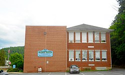
Old Gregg School Community Center in Spring Mills, PA
Map of Pennsylvania highlighting Centre County.svg
Location of Centre County in Pennsylvania
Coordinates: 40°51′18″N77°34′09″W / 40.85500°N 77.56917°W / 40.85500; -77.56917
CountryUnited States
StatePennsylvania
County Centre
Township Gregg
Area
  Total0.44 sq mi (1.1 km2)
  Land0.44 sq mi (1.1 km2)
  Water0.0 sq mi (0 km2)
Elevation
1,100 ft (300 m)
Population
 (2010)
  Total268
  Density610/sq mi (240/km2)
Time zone UTC-5 (EST)
  Summer (DST) UTC-4 (EDT)
ZIP code
16875
Area code Area code 814
FIPS code 42-73288
GNIS feature ID1188247

Spring Mills is an unincorporated community and census-designated place (CDP) in Centre County, Pennsylvania, United States. It is part of the State College, Pennsylvania Metropolitan Statistical Area. The population was 268 at the 2010 census. [1]

Contents

Geography

Spring Mills is located in southeastern Centre County, near the center of Gregg Township. It is in the Penns Valley, at the confluence of Sinking Creek with Penns Creek. According to the United States Census Bureau, the CDP has a total area of 0.44 square miles (1.15 km2), all land.

Pennsylvania Route 45 runs along the northern edge of the community, leading west 6 miles (10 km) to Centre Hall and 17 miles (27 km) to State College, and east 5 miles (8 km) to Millheim.

Demographics

At the 2010 census there were 268 people, 109 households, and 83 families in the CDP. The population density was 577.0 inhabitants per square mile (222.8/km2). There were 116 housing units at an average density of 249.7/sq mi (96.4/km2). The racial makeup of the CDP was 99.6% White and 0.4% of two or more races. Hispanic or Latino of any race were 0.4%. [2]

There were 109 households, 28.4% had children under the age of 18 living with them, 62.4% were married couples living together, 7.3% had a male householder with no wife present, 6.4% had a female householder with no husband present, and 23.9% were non-families. 20.2% of households were made up of individuals, and 10.1% were one person aged 65 or older. The average household size was 2.46 and the average family size was 2.83.

The age distribution was 18.7% under the age of 18, 10.4% from 18 to 24, 24.6% from 25 to 44, 28.8% from 45 to 64, and 17.5% 65 or older. The median age was 42 years. For every 100 females, there were 106.2 males. For every 100 females age 18 and over, there were 111.7 males.

The median household income was $38,542 and the median family income was $42,083. The per capita income for the CDP was $21,941. About 13.2% of families and 7.3% of the population were below the poverty line, including 7.5% of those under the age of 18 and 18.6% of those 65 or over.

Related Research Articles

<span class="mw-page-title-main">Lower Alsace Township, Berks County, Pennsylvania</span> Township in Pennsylvania, United States

Lower Alsace Township is a township in Berks County, Pennsylvania. The population was 4,475 at the 2010 census. By area, it is the smallest township in Berks County.

<span class="mw-page-title-main">Nixon, Pennsylvania</span> Census-designated place in Pennsylvania, United States

Nixon is a census-designated place (CDP) in Butler County, Pennsylvania, United States. The population was 1,373 at the 2010 census.

<span class="mw-page-title-main">Spring Hill, Pennsylvania</span>

Spring Hill is a census-designated place (CDP) in Cambria County, Pennsylvania, United States. The population was 839 at the 2010 census, down from 970 at the 2000 census.

<span class="mw-page-title-main">Coburn, Pennsylvania</span> Census-designated place in Pennsylvania, United States

Coburn is a census-designated place (CDP) in Centre County, Pennsylvania, United States. It is part of the State College, Pennsylvania Metropolitan Statistical Area. The population was 236 at the 2010 census.

<span class="mw-page-title-main">Gregg Township, Centre County, Pennsylvania</span> Township in Pennsylvania, United States

Gregg Township is a township in Centre County, Pennsylvania, United States. It is part of the State College, Pennsylvania Metropolitan Statistical Area. The population was 2,287 at the 2020 census.

<span class="mw-page-title-main">Houserville, Pennsylvania</span> Census-designated place in Pennsylvania, United States

Houserville is an unincorporated community and census-designated place (CDP) in Centre County, Pennsylvania, United States. It is part of the State College, Pennsylvania Metropolitan Statistical Area. The population was 1,814 at the 2010 census.

<span class="mw-page-title-main">Sandy Ridge, Pennsylvania</span> Census-designated place in Pennsylvania, United States

Sandy Ridge is an unincorporated community and census-designated place (CDP) in Centre County, Pennsylvania, United States. It is part of the State College, Pennsylvania Metropolitan Statistical Area. The population was 407 at the 2010 census.

<span class="mw-page-title-main">Woodward, Pennsylvania</span> Census-designated place in Pennsylvania, United States

Woodward is an unincorporated community and census-designated place in Centre County, Pennsylvania, United States. It is part of the State College, Pennsylvania, Metropolitan Statistical Area. The population was 110 at the 2010 census.

<span class="mw-page-title-main">Guys Mills, Pennsylvania</span> Census-designated place in Pennsylvania, United States

Guys Mills is a census-designated place in Crawford County, Pennsylvania, United States. The population was 124 at the 2010 census.

<span class="mw-page-title-main">Newmanstown, Pennsylvania</span> Census-designated place in Pennsylvania, United States

Newmanstown is an unincorporated community and census-designated place (CDP) in Millcreek Township, Lebanon County, Pennsylvania. The population was 2,478 at the 2010 census, an increase over the figure of 1,536 tabulated in 2000.

<span class="mw-page-title-main">Kulpsville, Pennsylvania</span> Census-designated place in Pennsylvania, United States

Kulpsville is a census-designated place (CDP) in Montgomery County, Pennsylvania. The population was 8,194 at the 2010 census. It is located in Towamencin Township, which is part of the North Penn Valley region that is centered around the borough of Lansdale. The name is derived from the Kulp family.

<span class="mw-page-title-main">Spring House, Pennsylvania</span> Census-designated place in Pennsylvania, United States

Spring House is a census-designated place (CDP) in Lower Gwynedd Township, Montgomery County, Pennsylvania, United States. The population was 3,978 at the 2020 census.

<span class="mw-page-title-main">Spring Mount, Pennsylvania</span> Census-designated place in Pennsylvania, United States

Spring Mount is a census-designated place (CDP) in Montgomery County, Pennsylvania, United States. The population was 2,259 at the 2010 census.

<span class="mw-page-title-main">Trooper, Pennsylvania</span> Census-designated place in Pennsylvania, United States

Trooper is a census-designated place (CDP) in Lower Providence Township, Montgomery County, Pennsylvania, United States. The population was 5,744 at the 2010 census.

Fountain Springs is a census-designated place in Butler Township, Schuylkill County, Pennsylvania, United States. The population was 100 at the 2000 census.

<span class="mw-page-title-main">Mount Pleasant Mills, Pennsylvania</span> CDP in Pennsylvania, United States

Mount Pleasant Mills is a census-designated place (CDP) in Snyder County, Pennsylvania, United States. The population was 342 at the 2000 census.

Linntown is a census-designated place (CDP) in East Buffalo Township, Union County, Pennsylvania, United States. The population was 1,489 at the 2010 census.

<span class="mw-page-title-main">Harrison City, Pennsylvania</span> Census-designated place in Pennsylvania, United States

Harrison City is a census-designated place (CDP) in Westmoreland County, Pennsylvania, United States. The population was 174 at the 2020 census.

<span class="mw-page-title-main">Parkville, Pennsylvania</span> CDP in Pennsylvania, United States

Parkville is a census-designated place (CDP) in York County, Pennsylvania, United States. The population was 6,706 at the 2010 census.

<span class="mw-page-title-main">Pennville, Pennsylvania</span> CDP in Pennsylvania, United States

Pennville is a census-designated place (CDP) in York County, Pennsylvania, United States. The population was 1,947 at the 2010 census.

References

  1. "Geographic Identifiers: 2010 Census Summary File 1 (G001): Spring Mills CDP, Pennsylvania". U.S. Census Bureau, American Factfinder. Archived from the original on April 22, 2015. Retrieved April 21, 2015.
  2. "U.S. Census website". United States Census Bureau . Retrieved January 31, 2008.