
Centre County is a county in the U.S. state of Pennsylvania. As of the 2020 census, the population was 158,172. Its county seat is Bellefonte. Centre County comprises the State College, PA Metropolitan Statistical Area.

Peeples Valley is a census-designated place (CDP) in Yavapai County, Arizona, United States. The population was 374 at the 2000 census.

Yarnell is a census-designated place (CDP) in Yavapai County, Arizona, United States. The population of Yarnell was 649 at the 2010 census. Yarnell's economy is based on ranching, mining and services to travelers and retirees. Peeples Valley, three miles north, is closely linked to Yarnell.

Exeter Township is a township in Berks County, Pennsylvania, United States. The population was 25,500 as of the 2020 Census, making it the third-most populous municipality in Berks County after the city of Reading and Spring Township. Daniel Boone Homestead is within its borders. This formerly rural township is now made up of mostly sprawl-oriented developments along U.S. Route 422 and Route 562 Its school district also contains the adjacent borough of St. Lawrence.
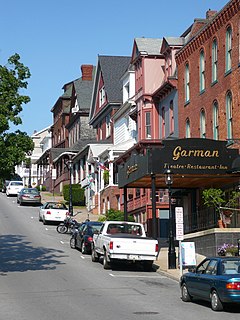
Bellefonte is a borough in, and the county seat of, Centre County in the U.S. state of Pennsylvania. It is approximately twelve miles northeast of State College and is part of the State College, Pennsylvania Metropolitan Statistical Area. The borough population was 6,187 at the 2010 Census. It houses the Centre County Courthouse, located downtown on the diamond. Bellefonte has also been home to five of Pennsylvania's governors, as well as two other governors. All seven are commemorated in a monument located at Talleyrand Park.
Boggs Township is a township in Centre County, Pennsylvania, United States. It is part of the State College, Pennsylvania Metropolitan Statistical Area. It is located north of Bellefonte at approximately 40°54′48″N77°45′53″W. As of the 2010 census, the township population was 2,985.

Whipple Dam State Park is a Pennsylvania state park on 256 acres (104 ha) in Jackson Township, Huntingdon County, Pennsylvania in the United States. Whipple Lake is a man-made lake on 22 acres (8.9 ha) that was originally built during the height of the lumber era that swept through Pennsylvania in the late 19th and early 20th century to supply power for a sawmill. Whipple Dam State Park is 12 miles (19 km) south of State College, just east of Pennsylvania Route 26.
Pennsylvania's 17th congressional district is represented by Democrat Conor Lamb. The district encompasses the entirety of Beaver County, a small portion of southwestern Butler County, and all parts of Allegheny County not part of the 18th district.

Reeds Gap State Park is a 220 acres (89 ha) Pennsylvania state park in Armagh Township, Mifflin County, Pennsylvania in the United States. The park is largely a wilderness area with large white pine and hemlock trees. Honey Creek flows through the park, providing a habitat for trout. Reeds Gap State Park is 7 miles (11 km) from U.S. Route 322 near Milroy in New Lancaster Valley and Bald Eagle State Forest.

Poe Paddy State Park is a 23-acre (9.3 ha) Pennsylvania state park in Haines Township, Centre County, Pennsylvania in the United States. The park is surrounded by Bald Eagle State Forest. Poe Valley State Park is 4 miles (6.4 km) to the east. The park is at the confluence of Big Poe Creek and Penns Creek. Poe Paddy State Park is named for the two mountains that surround it. Poe Mountain lies to the east and Paddy Mountain lies to the west, with Penns Creek in the valley between them.

McCalls Dam State Park is a Pennsylvania state park on 8 acres (3.2 ha) in Miles Township, Centre County, Pennsylvania in the United States. The park is in the easternmost tip of Centre County, south of Clinton County and north of Union County. McCalls Dam State Park is in a remote location on a gravel road between R. B. Winter State Park on Pennsylvania Route 192 and Eastville on Pennsylvania Route 880. The park can only be accessed in the winter months by snowmobiling or cross-country skiing.

Penn-Roosevelt State Park is a 41 acres (17 ha) Pennsylvania state park in Harris Township, Centre County, Pennsylvania in the United States. The park is surrounded by Rothrock State Forest. Penn-Roosevelt State Park is 6 miles (9.7 km) from U.S. Route 322 on either Crowfield Road or Stone Creek Road.

This is a list of the National Register of Historic Places listings in Centre County, Pennsylvania.
Yarnell is an unincorporated community in the towns of Couderay and Edgewater, Sawyer County, Wisconsin, United States. Yarnell is 7.5 miles (12.1 km) southwest of the village of Couderay.

The Yarnell Hill Fire was a wildfire near Yarnell, Arizona, ignited by dry lightning on June 28, 2013. On June 30, it overran and killed 19 members of the Granite Mountain Hotshots. Just one of the hotshots on the crew survived—he was posted as a lookout on the fire and was not with the others when the fire overtook them. The Yarnell Hill Fire was one of the deadliest U.S. wildfires since the 1991 Oakland Hills fire, which killed 25 people, and the deadliest wildland fire for U.S. firefighters since the 1933 Griffith Park fire, which killed 29 "impromptu" civilian firefighters drafted on short notice to help battle that Los Angeles area fire.

The Prescott Fire Department is the municipal fire department for the city of Prescott, Arizona. Additionally, the PFD provides aircraft rescue and firefighting for the Prescott Municipal Airport. Founded in 1885, it is the oldest fire department in the state of Arizona. With a coverage area of 41.5 square miles (107 km2) and serving a population of 39,843, the PFD consists of 92 career personnel, split among five fire stations.
Yarnell is an unincorporated historic locale in Lane County, Oregon, United States. It was located about 5 miles south of Mohawk, in the Mohawk Valley.

Victor Robert Hewlett Yarnell was a Canadian-born American politician who served as the Mayor of Reading, Pennsylvania as a Democrat between 1968 and 1972.
The Pennsylvania State Game Lands Number 60 are Pennsylvania State Game Lands in Blair, Centre and Clearfield Counties in Pennsylvania in the United States providing hunting, bird watching, and other activities.
Wingate is an unincorporated community in Boggs Township, Centre County, Pennsylvania, United States. It is at the junction of PA 144 and PA 504.

