Rebersburg, Pennsylvania

Last updated

Rebersburg, Pennsylvania
House in Rebersburg PA.jpg
House in Rebersburg
Map of Rebersburg, Centre County, Pennsylvania Highlighted.png
Location within Centre County
USA Pennsylvania location map.svg
Red pog.svg
Rebersburg
Location within the U.S. state of Pennsylvania
Usa edcp location map.svg
Red pog.svg
Rebersburg
Rebersburg (the United States)
Coordinates: 40°56′49″N77°26′38″W / 40.94694°N 77.44389°W / 40.94694; -77.44389
Country United States
State Pennsylvania
County Centre
Township Miles
Area
[1]
  Total1.36 sq mi (3.52 km2)
  Land1.36 sq mi (3.52 km2)
  Water0.00 sq mi (0.00 km2)
Elevation
1,290 ft (390 m)
Population
 (2020) [2]
  Total488
  Density358.82/sq mi (138.56/km2)
Time zone UTC-5 (Eastern (EST))
  Summer (DST) UTC-4 (EDT)
ZIP code
16872
Area code 814
FIPS code 42-63688
GNIS code1184745

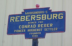
Rebersburg is an unincorporated community and census-designated place (CDP) in Centre County, Pennsylvania, United States. Rebersburg is part of the State College, Pennsylvania Metropolitan Statistical Area. The population was 494 at the 2010 census [3] and includes many Amish in the area. [4]

Contents

Geography

Rebersburg is located in eastern Centre County at 40°56′49″N77°26′38″W / 40.94694°N 77.44389°W / 40.94694; -77.44389 (40.946852, -77.443835), [5] in the western part of Miles Township. It is in the Brush Valley, part of the Ridge-and-Valley Province of the Appalachian Mountains, sitting between Nittany Mountain to the north and Brush Mountain/Shriner Mountain to the south.

Pennsylvania Route 192 passes through the town as it runs the length of Brush Valley, leading west 4 miles (6 km) to Madisonburg and 14 miles (23 km) to Centre Hall, and east 31 miles (50 km) to Lewisburg. Pennsylvania Route 880 leads north from Rebersburg over Mount Nittany into Sugar Valley and the borough of Loganton.

According to the United States Census Bureau, Rebersburg has a total area of 1.36 square miles (3.52 km2), all land. [3]

Demographics

Historical population
CensusPop.Note
2020 488
U.S. Decennial Census [6]

As of the census [7] of 2010, there were 494 people, 179 households, and 134 families residing in the CDP. The population density was 328.1 inhabitants per square mile (126.7/km2). There were 195 housing units at an average density of 128.9/sq mi (49.8/km2). The racial makeup of the CDP was 97.8% White, 0.4% Black or African American, 0.2% Native American, 0.6% Asian, and 1.0% from two or more races.

There were 179 households, out of which 36.3% had children under the age of 18 living with them, 62.0% were married couples living together, 5.0% had a male householder with no wife present, 7.8% had a female householder with no husband present, and 25.1% were non-families. 20.7% of all households were made up of individuals, and 8.3% had someone living alone who was 65 years of age or older. The average household size was 2.76 and the average family size was 3.23.

In the CDP, the population was spread out, with 29.8% under the age of 18, 7.5% from 18 to 24, 21.3% from 25 to 44, 24.2% from 45 to 64, and 17.2% who were 65 years of age or older. The median age was 38 years. For every 100 females, there were 87.1 males. For every 100 females age 18 and over, there were 85.6 males.

The median income for a household in the CDP was $31,417, and the median income for a family was $41,458. The per capita income for the CDP was $21,702. About 3.0% of families and 7.7% of the population were below the poverty line, including 5.6% of those under age 18 and 4.4% of those age 65 or over.

Notable people

Related Research Articles

<span class="mw-page-title-main">Centre County, Pennsylvania</span> County in Pennsylvania, United States

Centre County is a county in the Commonwealth of Pennsylvania, United States. As of the 2020 census, the population was 158,172. Its county seat is Bellefonte. Centre County comprises the State College, PA Metropolitan Statistical Area. The northwestern part of Centre County is in the sparsely populated Pennsylvania Wilds region.

<span class="mw-page-title-main">Leesport, Pennsylvania</span> Borough in Pennsylvania, United States

Leesport is a borough in Berks County, Pennsylvania, United States. The population was 1,954 at the 2020 census.

<span class="mw-page-title-main">Coburn, Pennsylvania</span> Census-designated place in Pennsylvania, United States

Coburn is a census-designated place (CDP) in Centre County, Pennsylvania, United States. It is part of the State College, Pennsylvania Metropolitan Statistical Area. The population was 236 at the 2010 census.

<span class="mw-page-title-main">Julian, Pennsylvania</span> Census-designated place in Pennsylvania, United States

Julian is an unincorporated community and census-designated place (CDP) that is located in Centre County, Pennsylvania, United States. It is part of the State College, Pennsylvania Metropolitan Statistical Area. The population was 152 at the 2010 census. Most locals pronounce the name "Joo-lee-ānn".

<span class="mw-page-title-main">Lemont, Pennsylvania</span> Census-designated place in Pennsylvania, United States

Lemont is an unincorporated community and census-designated place (CDP) in Centre County, Pennsylvania, United States, and is the location of the only remaining granary in Pennsylvania. It is part of the State College, Pennsylvania Metropolitan Statistical Area. The population was 2,270 at the 2010 census.

<span class="mw-page-title-main">Madisonburg, Pennsylvania</span> Census designated place in Pennsylvania, United States

Madisonburg is an unincorporated community and census-designated place (CDP) in Miles Township, Centre County, Pennsylvania, United States. It is part of the State College, Pennsylvania Metropolitan Statistical Area. The population was 168 at the 2010 census.

<span class="mw-page-title-main">Miles Township, Pennsylvania</span> Township in Pennsylvania, United States

Miles Township is a township in Centre County, Pennsylvania, United States. It is part of the State College, Pennsylvania Metropolitan Statistical Area. The population was 2,013 at the 2020 census, an increase over the figure of 1,983 tabulated in 2010. Miles Township and nearby Milesburg were named after Samuel Miles, who co-owned the Centre Furnace, along with Colonel John Patton.

<span class="mw-page-title-main">Monument, Pennsylvania</span> Census designated place in Pennsylvania, United States

Monument is an unincorporated community and census-designated place in Centre County, Pennsylvania, United States. It is part of the State College, Pennsylvania Metropolitan Statistical Area. The population was 150 at the 2010 census.

<span class="mw-page-title-main">Pine Grove Mills, Pennsylvania</span> Census-designated place in Pennsylvania, United States

Pine Grove Mills is an unincorporated community, village, and census-designated place (CDP) in Ferguson Township, Centre County, Pennsylvania, United States. It is part of the State College, Pennsylvania Metropolitan Statistical Area. The population was 1,481 at the 2020 census.

<span class="mw-page-title-main">Pleasant Gap, Pennsylvania</span> Census-designated place in Pennsylvania, United States

Pleasant Gap is an unincorporated community and census-designated place (CDP) in Centre County, Pennsylvania, United States. It is part of the State College, Pennsylvania Metropolitan Statistical Area. The population was 2,879 at the 2010 census.

<span class="mw-page-title-main">Woodward, Pennsylvania</span> Census-designated place in Pennsylvania, United States

Woodward is an unincorporated community and census-designated place in Haines Township, Centre County, Pennsylvania, United States. It is part of the State College, Pennsylvania, Metropolitan Statistical Area. The population was 110 at the 2010 census.

<span class="mw-page-title-main">Zion, Pennsylvania</span> Census-designated place in Pennsylvania, United States

Zion is an unincorporated community and census-designated place (CDP) in Centre County, Pennsylvania, United States.

<span class="mw-page-title-main">Castanea, Pennsylvania</span> Census-designated place in Pennsylvania, United States

Castanea is a census-designated place (CDP) in Castanea Township, Clinton County, Pennsylvania, United States. The population was 1,125 at the 2010 census.

Schlusser is a census-designated place (CDP) in North Middleton and Middlesex townships, Cumberland County, Pennsylvania, United States. The population was 5,265 at the 2010 census. It is part of the Harrisburg–Carlisle Metropolitan Statistical Area.

Rouzerville is an unincorporated community and census-designated place (CDP) in Franklin County, Pennsylvania, United States. The population was 903 at the 2020 census.

<span class="mw-page-title-main">McAlisterville, Pennsylvania</span> Census-designated place in Pennsylvania, United States

McAlisterville is an unincorporated community and census-designated place (CDP) in Fayette Township, Juniata County, Pennsylvania, United States. The population was 971 at the 2010 census.

Milroy is a census-designated place (CDP) that is located in the Kishacoquillas Valley of Mifflin County, Pennsylvania, United States. The population was 1,386 at the time of the 2000 census.

<span class="mw-page-title-main">Reedsville, Pennsylvania</span> Census-designated place in Pennsylvania, United States

Reedsville is a census-designated place (CDP) in the Kishacoquillas Valley of Mifflin County, Pennsylvania, United States. The population was 641 at the 2010 census. Reedsville has a high Amish population.

<span class="mw-page-title-main">Brodheadsville, Pennsylvania</span> Census-designated place in Pennsylvania, United States

Brodheadsville is a census-designated place (CDP) in Monroe County, Pennsylvania, United States. The population was 1,700 at the 2020 census. The community is served by Pleasant Valley School District.

<span class="mw-page-title-main">Valley View, York County, Pennsylvania</span> CDP in Pennsylvania, United States

Valley View is a census-designated place (CDP) in York County, Pennsylvania, United States. The population was 2,817 at the 2010 census.

References

  1. "ArcGIS REST Services Directory". United States Census Bureau. Retrieved August 8, 2023.
  2. "Census Population API". United States Census Bureau. Retrieved August 8, 2023.
  3. 1 2 "Geographic Identifiers: 2010 Census Summary File 1 (G001): Rebersburg CDP, Pennsylvania". U.S. Census Bureau, American Factfinder. Archived from the original on April 22, 2015. Retrieved April 21, 2015.
  4. "Rebersburg". StateCollege.com. Retrieved September 6, 2016.
  5. "US Gazetteer files: 2010, 2000, and 1990". United States Census Bureau. February 12, 2011. Retrieved April 23, 2011.
  6. "Census of Population and Housing". Census.gov. Retrieved June 4, 2016.
  7. "U.S. Census website". United States Census Bureau . Retrieved January 31, 2008.

Onboard Informatics. "Rebersburg, Pennsylvania". City-Data Forum. Advameg, Inc. Retrieved April 7, 2011.