Livonia, Pennsylvania

Last updated
Livonia, Pennsylvania
unincorporated community
USA Pennsylvania location map.svg
Red pog.svg
Livonia, Pennsylvania
Location within the state of Pennsylvania
Coordinates: 40°58′50″N77°17′30″W / 40.98056°N 77.29167°W / 40.98056; -77.29167 Coordinates: 40°58′50″N77°17′30″W / 40.98056°N 77.29167°W / 40.98056; -77.29167
Country United States
State Pennsylvania
County Centre County
Township Miles Township
Settled~1840
Elevation
1,499 ft (457 m)
Time zone Eastern (EST)
  Summer (DST)EDT
ZIP code
16872
Area code(s) 570

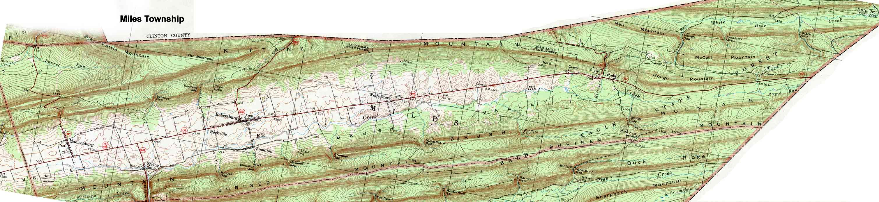
Livonia is an unincorporated community in the Appalachian Mountains of central Pennsylvania, United States. Livonia is in Miles Township, Centre County, near the head of Brush Valley, just west of Hough Mountain and just north of Elk Creek. [1] It is located on Railroad Creek at the intersection of Pennsylvania Routes PA 477 and PA 192. Elevation is 1,499 feet. [2] The nearest post office is in Loganton, Pennsylvania, but mail in handled out of Rebersburg.

Appalachian Mountains mountain range in the eastern United States and Canada, and France

The Appalachian Mountains, often called the Appalachians, are a system of mountains in eastern North America. The Appalachians first formed roughly 480 million years ago during the Ordovician Period. They once reached elevations similar to those of the Alps and the Rocky Mountains before experiencing natural erosion. The Appalachian chain is a barrier to east–west travel, as it forms a series of alternating ridgelines and valleys oriented in opposition to most highways and railroads running east–west.

Pennsylvania U.S. state in the United States

Pennsylvania, officially the Commonwealth of Pennsylvania, is a state located in the Northeastern, Great Lakes and Mid-Atlantic regions of the United States. The Appalachian Mountains run through its middle. The Commonwealth is bordered by Delaware to the southeast, Maryland to the south, West Virginia to the southwest, Ohio to the west, Lake Erie and the Canadian province of Ontario to the northwest, New York to the north, and New Jersey to the east.

Miles Township, Centre County, Pennsylvania Township in Pennsylvania, United States

Miles Township is a township in Centre County, Pennsylvania, United States. It is part of the State College, Pennsylvania Metropolitan Statistical Area. The population was 1,983 at the 2010 census, up from 1,573 at the 2000 census. Miles Township and nearby Milesburg were named after Miles Davis, who co-owned the Centre Furnace, along with Colonel John Patton.

Nearby is Bald Eagle State Forest and White Deer Creek is known for its fly-fishing. [3]

Bald Eagle State Forest

Bald Eagle State Forest is a Pennsylvania state forest in Pennsylvania Bureau of Forestry District #7. The main office is located in Laurelton in Union County, Pennsylvania, in the United States. The forest is found in Centre, Clinton, Mifflin, Snyder, and Union Counties. Bald Eagle shares a common border on its western extent with Rothrock State Forest and on its northern extent with Tiadaghton State Forest.

History

Livonia was first settled in the 1840s, but the economy did not flourish until the railroad spur reached them about 1900 during a logging boom. [4] There was a Civilian Conservation Corps camp there from 1933 to 1942. [5]

Civilian Conservation Corps public work relief program

The Civilian Conservation Corps (CCC) was a voluntary public work relief program that operated from 1933 to 1942 in the United States for unemployed, unmarried men. Originally for young men ages 18–25, it was eventually expanded to ages 17–28. Robert Fechner was the first director of this agency, succeeded by James McEntee following Fechner's death. The CCC was a major part of President Franklin D. Roosevelt's New Deal that provided unskilled manual labor jobs related to the conservation and development of natural resources in rural lands owned by federal, state, and local governments. The CCC was designed to provide jobs for young men and to relieve families who had difficulty finding jobs during the Great Depression in the United States. Maximum enrollment at any one time was 300,000. Through the course of its nine years in operation, 3 million young men participated in the CCC, which provided them with shelter, clothing, and food, together with a wage of $30 per month.

Notes and references

  1. United States Geological Survey. Miles Township Map (Map). Archived from the original on 4 January 2015.
  2. U.S. Geological Survey Geographic Names Information System: Livonia, Pennsylvania
  3. Wolf, Dave (2007). "White Deer Creek". Flyfisher's Guide to Pennsylvania. Belgrade, Montana: Wilderness Adventures Press. p. 132. ISBN   978-1-932098-51-8.
  4. Snyder, Charles McCool; et al. (2000). Union County, Pennsylvania: A Celebration of History (second ed.). Lewisburg, Pennsylvania: Union County Historical Society. p. 210. ISBN   978-0-917127-13-7.
  5. Speakman, Joseph M. (2006). At Work in Penn's Woods: The Civilian Conservation Corps in Pennsylvania. University Park, Pennsylvania: Pennsylvania State University Press. p. 175. ISBN   978-0-271-02876-7.

Related Research Articles

Sullivan County, Pennsylvania U.S. county in Pennsylvania

Sullivan County is a county located in the U.S. state of Pennsylvania. As of the 2010 census, the population was 6,428, making it the second-least populous county in Pennsylvania. Its county seat is Laporte. The county was created on March 15, 1847, from part of Lycoming County and named for Charles C. Sullivan, leader of the Pennsylvania Senate at that time.

Washington Township, Lycoming County, Pennsylvania Township in Pennsylvania, United States

Washington Township is a township in Lycoming County, Pennsylvania, United States. The population was 1,613 at the 2000 census. It is part of the Williamsport, Pennsylvania Metropolitan Statistical Area.

Ricketts Glen State Park

Ricketts Glen State Park is a Pennsylvania state park on 13,050 acres (5,280 ha) in Columbia, Luzerne, and Sullivan counties in Pennsylvania in the United States. Ricketts Glen is a National Natural Landmark known for its old-growth forest and 24 named waterfalls along Kitchen Creek, which flows down the Allegheny Front escarpment from the Allegheny Plateau to the Ridge-and-Valley Appalachians. The park is near the borough of Benton on Pennsylvania Route 118 and Pennsylvania Route 487, and is in five townships: Sugarloaf in Columbia County, Fairmount and Ross in Luzerne County, and Colley and Davidson in Sullivan County.

Larrys Creek tributary of the West Branch Susquehanna River

Larrys Creek is a 22.9-mile-long (36.9 km) tributary of the West Branch Susquehanna River in Lycoming County in the U.S. state of Pennsylvania. A part of the Chesapeake Bay drainage basin, its watershed drains 89.1 square miles (231 km2) in six townships and a borough. The creek flows south from the dissected Allegheny Plateau to the Ridge-and-valley Appalachians through sandstone, limestone, and shale from the Devonian, Mississippian, and Pennsylvanian periods.

White Deer Hole Creek tributary of the West Branch Susquehanna River

White Deer Hole Creek is a 20.5-mile (33.0 km) tributary of the West Branch Susquehanna River in Clinton, Lycoming and Union counties in the U.S. state of Pennsylvania. A part of the Chesapeake Bay drainage basin, the White Deer Hole Creek watershed drains parts of ten townships. The creek flows east in a valley of the Ridge-and-valley Appalachians, through sandstone, limestone, and shale from the Ordovician, Silurian, and Devonian periods.

White Deer Creek tributary of the West Branch Susquehanna River

White Deer Creek is a tributary of the West Branch Susquehanna River in Centre County and Union County, in Pennsylvania, in the United States. It is approximately 28 miles (45 km) long and flows through Miles Township in Centre County and Hartley Township, Lewis Township, West Buffalo Township, and White Deer Township in Union County. The watershed of the creek has an area of 45.1 square miles (117 km2). Parts of the creek are designated as impaired. The creek's discharge near White Deer can be as low as 3 cubic feet per second (0.085 m3/s) or as high as 169 cubic feet per second (4.8 m3/s).

Little Pine State Park

Little Pine State Park is a Pennsylvania state park on 2,158 acres (873 ha) in Cummings Township, Lycoming County, Pennsylvania in the United States. Little Pine State park is along 4.2 miles (6.8 km) of Little Pine Creek, a tributary of Pine Creek, in the midst of the Tiadaghton State Forest. A dam on the creek has created a lake covering 94 acres (38 ha) for fishing, boating, and swimming. The park is on Pennsylvania Route 4001, 4 miles (6.4 km) northeast of the unincorporated village of Waterville or 8 miles (13 km) southwest of the village of English Center. The nearest borough is Jersey Shore, Pennsylvania, about 15 miles (24 km) south at the mouth of Pine Creek on the West Branch Susquehanna River.

Upper Pine Bottom State Park

Upper Pine Bottom State Park is a 5-acre (2.0 ha) Pennsylvania state park in Lycoming County, Pennsylvania in the United States. The park is in Cummings Township on Pennsylvania Route 44 and is surrounded by the Tiadaghton State Forest. It is on Upper Pine Bottom Run, which gave the park its name and is a tributary of Pine Creek. Upper Pine Bottom State Park is in the Pine Creek Gorge, where the streams have cut through five major rock formations from the Devonian and Carboniferous periods.

Kettle Creek State Park

Kettle Creek State Park is a 1,793-acre (726 ha) Pennsylvania state park in Leidy Township, Clinton County, Pennsylvania in the United States. The park is in a valley and is surrounded by mountains and wilderness. It features the Alvin R. Bush Dam built in 1961 by the U.S. Army Corps of Engineers as a flood control measure in the West Branch Susquehanna River basin. Many of the recreational facilities at the park were built during the Great Depression by the young men of the Civilian Conservation Corps. Kettle Creek State Park is seven miles (10 km) north of Westport and Pennsylvania Route 120. It is largely surrounded by Sproul State Forest.

Whipple Dam State Park state park in Pennsylvania

Whipple Dam State Park is a Pennsylvania state park on 256 acres (104 ha) in Jackson Township, Huntingdon County, Pennsylvania in the United States. Whipple Lake is a man-made lake on 22 acres (8.9 ha) that was originally built during the height of the lumber era that swept through Pennsylvania in the late 19th and early 20th century to supply power for a sawmill. Whipple Dam State Park is 12 miles (19 km) south of State College, just east of Pennsylvania Route 26.

Trough Creek State Park

Trough Creek State Park is a 554 acres (224 ha) Pennsylvania state park in Cass, Penn and Todd Townships, Huntingdon County, Pennsylvania in the United States. The majority of the park is in Todd Township along Pennsylvania Route 994, east of the unincorporated village of Entriken. Huntingdon is the nearest borough. The park borders Rothrock State Forest and Raystown Lake National Recreation Area. There is a growing population of bald eagles at the lake. Fourteen eagles were spotted in January 2007. This is up from two that were spotted in 1990, the first year that an eagle survey was taken. These three sections of state and federal owned property combine together to provide hunting, hiking and fishing opportunities for the outdoorsman.

Big Spring State Forest Picnic Area

Big Spring State Forest Picnic Area is a 45-acre (18 ha) Pennsylvania state park in Toboyne Township, Perry County, Pennsylvania in the United States. The park is on Pennsylvania Route 274, 5.5 miles (8.9 km) southwest of New Germantown. Big Spring State Forest Picnic Area is a hiking and picnic area. A partially completed railroad tunnel in Conococheague Mountain is a feature of the park.

Poe Paddy State Park

Poe Paddy State Park is a 23-acre (9.3 ha) Pennsylvania state park in Haines Township, Centre County, Pennsylvania in the United States. The park is surrounded by Bald Eagle State Forest. Poe Valley State Park is 4 miles (6.4 km) to the east. The park is at the confluence of Big Poe Creek and Penns Creek. Poe Paddy State Park is named for the two mountains that surround it. Poe Mountain lies to the east and Paddy Mountain lies to the west, with Penns Creek in the valley between them.

Pine Grove Furnace State Park

Pine Grove Furnace State Park is a protected Pennsylvania area that includes Laurel and Fuller Lakes in Cooke Township of Cumberland County. The Park accommodates various outdoor recreation activities, protects the remains of the Pine Grove Iron Works (1764), and was the site of Laurel Forge (1830), Pine Grove Park (1880s), and a brick plant (1892). The Park is 8 miles (13 km) from exit 37 of Interstate 81 on Pennsylvania Route 233.

Plunketts Creek (Loyalsock Creek tributary) river in the United States of America

Plunketts Creek is an approximately 6.2-mile-long (10 km) tributary of Loyalsock Creek in Lycoming and Sullivan counties in the U.S. state of Pennsylvania. Two unincorporated villages and a hamlet are on the creek, and its watershed drains 23.6 square miles (61 km2) in parts of five townships. The creek is a part of the Chesapeake Bay drainage basin via Loyalsock Creek and the West Branch Susquehanna and Susquehanna Rivers.

Pine Creek Rail Trail

The Pine Creek Rail Trail is a rail trail in the Appalachian Mountains of north-central Pennsylvania.

Leetonia, Pennsylvania Unincorporated community in Pennsylvania, United States

Leetonia is an unincorporated community in Elk Township, Tioga County, in the U.S. state of Pennsylvania. It lies along Leetonia Road, in the Tioga State Forest between Pennsylvania Route 414 and U.S. Route 6.

Lick Run (White Deer Creek tributary)

Lick Run is a tributary of White Deer Creek in Union County and Lycoming County, in Pennsylvania, in the United States. It is approximately 2.7 miles (4.3 km) long and flows through White Deer Township in Union County and Washington Township in Lycoming County. The watershed of the stream has an area of 2.10 square miles (5.4 km2). The stream has one unnamed tributary. Wild trout naturally reproduce within Lick Run, and beavers began assembling a dam on it at least once.

Sand Spring Run tributary of White Deer Creek in Pennsylvania, United States

Sand Spring Run is a tributary of White Deer Creek in Union County, Pennsylvania, in the United States. It is approximately 5.7 miles (9.2 km) long and flows through Lewis Township and West Buffalo Township. The watershed of the stream has an area of 4.94 square miles (12.8 km2). The stream is not designated as an impaired waterbody. It is a mountainous freestone stream and is mostly in Bald Eagle State Forest.

Tunis Run is a tributary of White Deer Creek in Centre County, Pennsylvania, in the United States. It is approximately 1.5 miles (2.4 km) long and flows through Miles Township. The watershed of the stream has an area of 1.43 square miles (3.7 km2). The stream is situated near Hough Gap and a railroad was once built near it. Wild trout naturally reproduce within it.