
Riverton, officially Riverton / Aparima, is a small New Zealand town 30 kilometres (19 mi) west of Invercargill, on the south-eastern shorelines of the Jacobs River Estuary. The estuary is formed by the Aparima and Pourakino rivers, leading through a narrow outflow channel into Foveaux Strait. Accessible via State Highway 99 on the Southern Scenic Route, the main part of the town is on flat land and the northern end of Oreti Beach. South Riverton is built on the hills between the eastern shore of the estuary and Taramea Bay.

Tuatapere is a small rural town in Southland, New Zealand. It is the self declared "Sausage Capital of New Zealand". Tuatapere is located eight kilometres from the southern coast. The Waiau River flows through the town before reaching Te Waewae Bay, where it has its outflow into Foveaux Strait. The main local industries are forestry and farming.

Te Waewae Bay is the westernmost of three large bays lying on the Foveaux Strait coast of Southland, New Zealand, the others being Oreti Beach and Toetoes Bay. Twenty-seven kilometres in length, the western end of the bay is mountainous, with the southern terminus of the Southern Alps and Fiordland National Park.

The Waiau River is the largest river in the Southland region of New Zealand. 'Waiau' translates to 'River of Swirling Currents'. It is the outflow of Lake Te Anau, flowing from it into Lake Manapouri 10 kilometres (6 mi) to the south, and from there flows south for 70 kilometres (43 mi) before reaching the Foveaux Strait 8 kilometres (5 mi) south of Tuatapere. It also takes water from Lake Monowai.

The New Zealand Great Walks are a set of popular tramping tracks developed and maintained by the Department of Conservation. They are New Zealand's premier tracks, through areas of some of the best scenery in the country, ranging from coastlines with beaches to dense rain forests and alpine terrain. The tracks are maintained to a high standard, making it easier for visitors to explore some of the most scenic parts of New Zealand's backcountry.
The Tokanui Branch, also known as the Seaward Bush Branch, was a branch line railway located in Southland, New Zealand. It diverged from the Bluff Branch south of the main railway station in Invercargill and ran for 54 kilometres in a southeasterly direction. Construction began in 1883 and it operated until 1966.
The Tuatapere Branch, including the Orawia Branch, was a branch line railway in Southland, New Zealand. Although the Tuatapere and Orawia Branches look like a single line, operationally they were considered separate lines. The first section opened to Riverton in 1879 and reached Tuatapere three decades later. The extension from Tuatapere to Orawia operated from 1925 until 1970. In 1976 the Tuatapere Branch was truncated to Riverton, and was known as the Riverton Branch until 1978, when it closed beyond Thornbury. The remaining portion of the line is now part of the Wairio Branch.
The Ohai Line, formerly known as the Ohai Industrial Line and previously the Wairio Branch and the Ohai Railway Board's line, is a 54.5 km branch line railway in Southland, New Zealand. It opened in 1882 and is one of two remaining branch lines in Southland, and one of only a few in the country. A number of smaller privately owned railways fanned out from Wairio; one of these lines, to Ohai, was originally built by the Ohai Railway Board and was worked by New Zealand Railways from 1990 and incorporated into the national network in 1992.
Orepuki in Southland, New Zealand is a small country township on the coast of Te Waewae Bay some 20 minutes from Riverton, 15 minutes from Tuatapere and 50 minutes from Invercargill that sits at the foot of the Longwood Range. Once a thriving gold mining settlement of 3000 people, today Orepuki is something of a ghost town with an assortment of abandoned stores, goldmining relics and sluicing scars as the only reminders of its former glory.

The Hump Ridge Track, also called the Tuatapere Hump Ridge Track, is a 61 km walking track that is partly in Fiordland National Park in New Zealand. The track was opened in 2001 and is run privately on behalf of the Tuatapere Hump Ridge Track Charitable Trust.
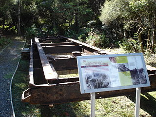
Port Craig is located along the south coast of the South Island New Zealand near Tuatapere. It was a small logging town born in 1916, with 200+ men women and children living there in its prime. Like other New Zealand bush towns, Port Craig was inhabited by hardy kiwi bushmen and their families, recent immigrants and a few others trying to keep clear of the law. The Marlborough Timber Company had a large scale plan to log one of the countries last significant coastal forests. The company planned big, they built the Dominion's largest sawmill, an extensive tramway system, port facilities and township all without road access. The bush was worked by the Lidgerwood overhead logging cable system (gantry) that weighed over 50 tonnes. The immense size of the gantry meant that it was very difficult to relocate in the inhospitable forest and after one major shift, the gantry was left redundant, crippling the local logging industry.

The Wynyard Quarter is a reclaimed piece of land on the Waitematā Harbour at the western edge of the Auckland waterfront, New Zealand.
Fortification is a locality in the western part of the Catlins region of Southland in New Zealand's South Island. Nearby settlements include Quarry Hills and Waikawa to the southeast, Tokanui to the southwest, and Waimahaka to the west. It is over 50 km east of Southland's main centre, Invercargill.

The Big River has also been known by several other names, Windsor River and Māori names Hakapoua, Okopowa, Patu-po, or Patupō, though that last name, meaning kill by night, might refer to a place near Long Point and Waitutu. It is a river of southern Fiordland, New Zealand, and is one of three rivers of that name in the South Island. It is the main source of Lake Hakapoua and a lower stretch is the lake's 2-kilometre (1.2 mi) outflow to the sea. The river rises on the 1,123 m (3,684 ft) high Arnett Peak, in the Cameron Mountains, runs about 23 km (14 mi) to the lake. At about the mid point of the river it runs through a narrow gorge. Elsewhere it is generally very shallow. The river is in the Fiordland National Park.
The Makatote River is a river of the centre of New Zealand's North Island. It flows west from the slopes of Mount Ruapehu, and from the Hauhungatahi Wilderness Area, before entering rough hill country, veering southwest and entering a gorge cut almost 100 m (330 ft) into the volcanic rocks. It joins with the waters of several smaller streams to become the Manganui o te Ao River, part of the Whanganui River system.
Clifden, New Zealand is a small rural community on the Waiau River, Southland, New Zealand.

The Timber Trail, originally known as the Central North Island Rail Trail or Pureora Timber Trail, in the North Island of New Zealand is an 84-kilometre (52 mi) cycleway in Pureora Forest Park, fully opened in 2013, with 35 bridges, including eight large suspension bridges. It is one of several cycleways developed as part of the New Zealand Cycle Trail and passes through some of the last remaining podocarp forests of rimu, tōtara, miro, mataī and kahikatea, as well as some exotic forestry and regenerating bush. About half the trail is on the track-bed of the old Ellis and Burnand Tramway, including a spiral and tunnel.
Elaine Bay is a bay located in Pelorus Sound / Te Hoiere, within the Marlborough Sounds at the north end of the South Island of New Zealand. Elaine Bay is in the Tawhitinui Reach, which includes other bays such as Tennyson Inlet, Fitzroy Bay and Hallum Cove. The bay is accessed by the Elaine Bay Road, which connects with the Croisilles-French Pass Road at the top of the ridge.

The Makatote Tramway was from the late 1920s to 1940 a 2.6 kilometres (1.6 mi) long bush tramway network near Makatote in the central North island of New Zealand with a gauge of 4 feet 1 inch (1,245 mm) using metal and wooden rails. It was operated by Dinwoodie's Timber Company with probably less than 10 employees.

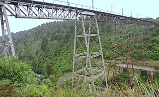
The Port Craig tramway was an overall 24.4 kilometres (15.2 mi) long, bush tramway with a gauge of 3 ft 6 in at Port Craig in New Zealand, which operated from 1917 to 1928.

