
Mecklenburg-Vorpommern, internationally also known by its anglicized name Mecklenburg-Western Pomerania, is a state in the north-east of Germany. Of the country's sixteen states, Mecklenburg-Vorpommern ranks 14th in population, 6th in area, and 16th in population density. Schwerin is the state capital and Rostock is the largest city. Other major cities include Neubrandenburg, Stralsund, Greifswald, Wismar and Güstrow.

Ribnitz-Damgarten is a town in Mecklenburg-Vorpommern, Germany, situated on Lake Ribnitz. Ribnitz-Damgarten is in the west of the district Vorpommern-Rügen.
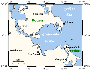
The Bay of Greifswald or Greifswald Bodden is a basin in the southwestern Baltic Sea, off the shores of Germany in the state of Mecklenburg-Vorpommern. With an area of 514 km², it is the largest Bodden of the German Baltic coast.

Barth is a town in Mecklenburg-Vorpommern, Germany. It is situated at a lagoon (Bodden) of the Baltic Sea facing the Fischland-Darss-Zingst peninsula. Barth belongs to the district of Vorpommern-Rügen. It is close to the Western Pomerania Lagoon Area National Park. In 2011, it held a population of 8,706.

Fischland-Darß-Zingst or Fischland-Darss-Zingst is a 45 km (28 mi) long peninsula in the coastal district of Vorpommern-Rügen, in the German state of Mecklenburg-Vorpommern. The three parts of the peninsula, from west to east, are Fischland, Darß and Zingst.

Bodden are briny bodies of water often forming lagoons, along the southwestern shores of the Baltic Sea, primarily in Germany's state of Mecklenburg-Vorpommern. These lagoons can be found especially around the island of Rügen, Usedom and the Fischland-Darss-Zingst peninsula. Some of them are protected reserves, forming the Western Pomerania Lagoon Area National Park.

Born auf dem Darß is a municipality in the Vorpommern-Rügen district, in Mecklenburg-Western Pomerania, Germany. It is part of the peninsula Darß, to which also belong the villages of Prerow and Wieck. Born is situated at the southern shore of the peninsula Darß at the coastal lagoon, between Wieck and the Baltic seaside resort Ahrenshoop.

Ahrenshoop is a municipality in the Vorpommern-Rügen district, in Mecklenburg-Vorpommern, Germany on the Fischland-Darß-Zingst peninsula of the Baltic Sea. It used to be a small fishing village, but is today known for its tourism and as a holiday resort.

Dierhagen is a municipality in the Vorpommern-Rügen district, in Mecklenburg-Vorpommern, Germany. Among the approx. 1,600 inhabitants is Egon Krenz, briefly the leader of the GDR, who has lived there since 2006.

Prerow is a municipality in the district of Vorpommern-Rügen in the German state of Mecklenburg-Vorpommern. This Baltic seaside resort on the Darß peninsula is located about halfway between the historic Hanseatic towns of Rostock and Stralsund. It is one of three main settlements on the Darß, the others being the villages of Born and Wieck. Prerow has fine, sandy beaches and a picturesque landscape. It is hard to say where the forest ends and the village begins. The primeval Darß Forest has over 50 km of footpaths and cycle ways, a bridleway and tracks for horse-drawn carriages. West of the forest is West Beach with rugged terrain formed by wind and waves. South of Prerow is the bodden countryside. Visitors can take trips on a steam paddle boat and experience wildlife first-hand, nesting areas and various birds as the seasons change.

Wieck auf dem Darß is a municipality in the Vorpommern-Rügen district, in Mecklenburg-Vorpommern, Germany.
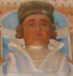
Barnim VI, Duke of Pomerania was duke of Pomerania-Wolgast from 1394 to 1405. He was the son of Wartislaw VI of Pomerania-Wolgast.

Pomerania during the Late Middle Ages covers the history of Pomerania in the 14th and 15th centuries.
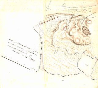
Duchy of Pomerania-Barth was a feudal duchy of the Holy Roman Empire located in Western Pomerania that existed in the Middle Ages between 1376 and 1478, and between 1569 and 1625. The state consisted of its capital, Barth, and nearby areas. Duchy had separated from Pomerania-Wolgast in 1376 and was incorporated into Duchy of Pomerania in 1478. It was reestablished in 1569 by separation from Pomerania-Wolgast-Stolp and existed until 1625, when it was incorporated into Duchy of Pomerania.
Vorpommern-Rügen is a district in the north of Mecklenburg-Vorpommern, Germany. It is bounded by the Baltic Sea and the districts Vorpommern-Greifswald, Mecklenburgische Seenplatte and Rostock. The district seat is the Hanseatic city of Stralsund.

The Darss-Zingst Bodden Chain is a waterbody on the Baltic Sea coast northeast of Rostock in Germany. It consists of a string of several lagoons or bodden arranged in an east-west direction that are separated from the open sea by the Fischland-Darß-Zingst peninsula. The surface area of these lagoons is 197 km² and the average water depth is only about two metres.

The Saaler Bodden forms the southwestern part of the Darss-Zingst Bodden Chain and lies east of the Fischland peninsula about 30 kilometres northeast of Rostock. Its average depth is around two metres, which restricts angling and the use of pleasure craft. It is a lagoon-like stretch of water known as a bodden, which is typical of this part of the Baltic coastline. South of the Saaler Bodden is the town of Ribnitz-Damgarten, which is divided into two by the mouth of the 72 kilometre long Recknitz river. This southern part of the bodden is called the Lake Ribnitz.

Fischland is an isthmus on the southern Baltic Sea coast on the Bay of Mecklenburg in northeastern Germany. It is part of the peninsula of Fischland-Darß-Zingst. Fischland was an island until the 14th century and was bounded by the navigable estuarine branches of the River Recknitz: the Permin in the south and the Loop in the north. In more recent times its southern boundary has usually been considered to be the Recknitz Meadowland and the Rostock Heath. To the west and east its boundaries are more obvious: on the one side is its active cliffed coast on the Baltic, and on the other the coastline alongside the Saaler Bodden, only a few centimetres above sea level. Fischland is about 5 km long, between 500 metres and 2 km wide and runs from southwest to northeast.
The Loop or Darss Canal was an inlet of the sea between the lagoon known as the Saaler Bodden and the Baltic Sea near Ahrenshoop on the German coast. It formed the northern boundary of the region of Fischland. Originally the Loop was the northern estuarine branch of the River Recknitz.

Historical Western Pomerania, also called Fore Pomerania, Front Pomerania or Hither Pomerania, is the western extremity of the historic region of the Duchy, later Province of Pomerania, nowadays divided between the states of Mecklenburg-Western Pomerania and Brandenburg in Germany and West Pomeranian Voivodeship in Poland.
