Perry County, New South Wales

Last updated

Map all coordinates using: OpenStreetMap
Perry
New South Wales
Perry NSW.PNG
Location in New South Wales
Lands administrative divisions around Perry:
Menindee Livingstone Manara
Windeyer Perry Manara
Wentworth Wentworth Kilfera

Perry County is one of the 141 Cadastral divisions of New South Wales. It is located to the east of the Darling River near Pooncarie.

Perry County was named in honour of Samuel Augustus Perry (1792–1854), soldier and surveyor. [1]

Parishes within this county

A full list of parishes found within this county; their current LGA and mapping coordinates to the approximate centre of each location is as follows:

ParishLGACoordinates
Astolat Central Darling Shire 32°50′25″S142°45′54″E / 32.84028°S 142.76500°E / -32.84028; 142.76500 (Astolat)
Barrara Wentworth Shire 33°06′55″S142°21′41″E / 33.11528°S 142.36139°E / -33.11528; 142.36139 (Barrara)
Barritt Wentworth Shire 32°57′37″S142°27′15″E / 32.96028°S 142.45417°E / -32.96028; 142.45417 (Barritt)
Beela Wentworth Shire 33°19′27″S143°14′44″E / 33.32417°S 143.24556°E / -33.32417; 143.24556 (Beela)
Bell Wentworth Shire 33°28′58″S142°42′15″E / 33.48278°S 142.70417°E / -33.48278; 142.70417 (Bell)
Bertram Wentworth Shire 33°25′44″S143°09′07″E / 33.42889°S 143.15194°E / -33.42889; 143.15194 (Bertram)
Bimpia Wentworth Shire 32°56′49″S142°59′21″E / 32.94694°S 142.98917°E / -32.94694; 142.98917 (Bimpia)
Blenalben Wentworth Shire 32°55′41″S143°16′39″E / 32.92806°S 143.27750°E / -32.92806; 143.27750 (Blenalben)
Burke Wentworth Shire 33°05′17″S142°44′22″E / 33.08806°S 142.73944°E / -33.08806; 142.73944 (Burke)
Camelot Wentworth Shire 33°00′35″S143°05′11″E / 33.00972°S 143.08639°E / -33.00972; 143.08639 (Camelot)
Coonong Wentworth Shire 33°00′12″S143°10′53″E / 33.00333°S 143.18139°E / -33.00333; 143.18139 (Coonong)
Cooyarunda Wentworth Shire 32°54′47″S142°51′50″E / 32.91306°S 142.86389°E / -32.91306; 142.86389 (Cooyarunda)
Darchy Wentworth Shire 33°20′54″S142°36′45″E / 33.34833°S 142.61250°E / -33.34833; 142.61250 (Darchy)
Enid Wentworth Shire 33°03′42″S142°58′23″E / 33.06167°S 142.97306°E / -33.06167; 142.97306 (Enid)
Euchla Wentworth Shire 33°20′44″S142°43′33″E / 33.34556°S 142.72583°E / -33.34556; 142.72583 (Euchla)
Garnpung Wentworth Shire 33°32′15″S143°08′07″E / 33.53750°S 143.13528°E / -33.53750; 143.13528 (Garnpung)
Glenstal Wentworth Shire 33°03′52″S142°22′56″E / 33.06444°S 142.38222°E / -33.06444; 142.38222 (Glenstal)
Gray Wentworth Shire 33°07′24″S143°04′14″E / 33.12333°S 143.07056°E / -33.12333; 143.07056 (Gray)
Gunpanoola Wentworth Shire 32°53′06″S142°44′47″E / 32.88500°S 142.74639°E / -32.88500; 142.74639 (Gunpanoola)
Harley Wentworth Shire 33°15′25″S142°37′09″E / 33.25694°S 142.61917°E / -33.25694; 142.61917 (Harley)
Howitt Wentworth Shire 33°12′07″S142°43′40″E / 33.20194°S 142.72778°E / -33.20194; 142.72778 (Howitt)
Kandra Wentworth Shire 33°11′43″S143°17′34″E / 33.19528°S 143.29278°E / -33.19528; 143.29278 (Kandra)
Karpakora Wentworth Shire 32°53′33″S143°06′10″E / 32.89250°S 143.10278°E / -32.89250; 143.10278 (Karpakora)
King Wentworth Shire 33°10′27″S142°57′25″E / 33.17417°S 142.95694°E / -33.17417; 142.95694 (King)
Mapenny Wentworth Shire 33°17′27″S142°56′26″E / 33.29083°S 142.94056°E / -33.29083; 142.94056 (Mapenny)
Midgehope Wentworth Shire 33°00′59″S143°21′13″E / 33.01639°S 143.35361°E / -33.01639; 143.35361 (Midgehope)
Mitchell Wentworth Shire 33°27′07″S142°55′02″E / 33.45194°S 142.91722°E / -33.45194; 142.91722 (Mitchell)
Mooloolerie Wentworth Shire 33°01′58″S142°44′48″E / 33.03278°S 142.74667°E / -33.03278; 142.74667 (Mooloolerie)
Moorara Wentworth Shire 33°10′29″S142°21′17″E / 33.17472°S 142.35472°E / -33.17472; 142.35472 (Moorara)
Morthong Wentworth Shire 33°11′48″S143°09′46″E / 33.19667°S 143.16278°E / -33.19667; 143.16278 (Morthong)
Mueller Wentworth Shire 33°24′13″S142°55′28″E / 33.40361°S 142.92444°E / -33.40361; 142.92444 (Mueller)
Mungo Wentworth Shire 33°23′01″S142°49′15″E / 33.38361°S 142.82083°E / -33.38361; 142.82083 (Mungo)
Mythe Wentworth Shire 33°08′35″S142°28′43″E / 33.14306°S 142.47861°E / -33.14306; 142.47861 (Mythe)
Nambucurra Wentworth Shire 33°14′14″S143°03′14″E / 33.23722°S 143.05389°E / -33.23722; 143.05389 (Nambucurra)
Nanda Wentworth Shire 33°03′40″S142°36′26″E / 33.06111°S 142.60722°E / -33.06111; 142.60722 (Nanda)
Nania Wentworth Shire 33°21′13″S143°02′12″E / 33.35361°S 143.03667°E / -33.35361; 143.03667 (Nania)
Nelia Wentworth Shire 33°11′08″S142°32′35″E / 33.18556°S 142.54306°E / -33.18556; 142.54306 (Nelia)
Nuccalo Wentworth Shire 32°49′15″S143°12′31″E / 32.82083°S 143.20861°E / -32.82083; 143.20861 (Nuccalo)
Pan Ban Wentworth Shire 33°16′52″S143°08′58″E / 33.28111°S 143.14944°E / -33.28111; 143.14944 (Pan Ban)
Peppora Wentworth Shire 32°52′12″S142°36′46″E / 32.87000°S 142.61278°E / -32.87000; 142.61278 (Peppora)
Perry Wentworth Shire 33°27′49″S143°01′13″E / 33.46361°S 143.02028°E / -33.46361; 143.02028 (Perry)
Pines Wentworth Shire 32°56′33″S142°36′58″E / 32.94250°S 142.61611°E / -32.94250; 142.61611 (Pines)
Pombra Wentworth Shire 33°08′34″S142°36′00″E / 33.14278°S 142.60000°E / -33.14278; 142.60000 (Pombra)
Pooncaira Wentworth Shire 33°28′06″S142°35′39″E / 33.46833°S 142.59417°E / -33.46833; 142.59417 (Pooncaira)
Porcupine Central Darling Shire 32°46′33″S142°54′17″E / 32.77583°S 142.90472°E / -32.77583; 142.90472 (Porcupine)
Prunella Central Darling Shire 32°44′41″S142°35′31″E / 32.74472°S 142.59194°E / -32.74472; 142.59194 (Prunella)
Tarcoola Wentworth Shire 33°27′55″S142°48′19″E / 33.46528°S 142.80528°E / -33.46528; 142.80528 (Tarcoola)
Tarmoola Wentworth Shire 33°03′07″S142°51′56″E / 33.05194°S 142.86556°E / -33.05194; 142.86556 (Tarmoola)
Tartna Central Darling Shire 32°53′32″S142°26′10″E / 32.89222°S 142.43611°E / -32.89222; 142.43611 (Tartna)
Timpunga Wentworth Shire 33°17′02″S142°29′15″E / 33.28389°S 142.48750°E / -33.28389; 142.48750 (Timpunga)
Tolarno Central Darling Shire
Tuckinya Wentworth Shire 32°46′45″S143°04′00″E / 32.77917°S 143.06667°E / -32.77917; 143.06667 (Tuckinya)
Wanteboolka Wentworth Shire 33°05′01″S143°15′15″E / 33.08361°S 143.25417°E / -33.08361; 143.25417 (Wanteboolka)
Welsh Wentworth Shire 33°12′49″S142°50′30″E / 33.21361°S 142.84167°E / -33.21361; 142.84167 (Welsh)
Wentworth Wentworth Shire 33°00′28″S142°29′32″E / 33.00778°S 142.49222°E / -33.00778; 142.49222 (Wentworth)
Wills Wentworth Shire 33°06′03″S142°51′30″E / 33.10083°S 142.85833°E / -33.10083; 142.85833 (Wills)
Wreford Wentworth Shire 33°12′37″S142°26′18″E / 33.21028°S 142.43833°E / -33.21028; 142.43833 (Wreford)
Yenda Central Darling Shire

Related Research Articles

<span class="mw-page-title-main">Perry County, Mississippi</span> County in Mississippi, United States

Perry County is a county located in the U.S. state of Mississippi. As of the 2020 census, the population was 11,511. The county seat is New Augusta. The county is named after the War of 1812 naval hero, Oliver Hazard Perry.

<span class="mw-page-title-main">Houston County, Georgia</span> County in Georgia, United States

Houston County is a county located in the central portion of the U.S. state of Georgia. The population was 163,633 at the 2020 census. Its county seat is Perry; the city of Warner Robins is substantially larger in both area and population.

<span class="mw-page-title-main">Perry, Georgia</span> City in Georgia, United States

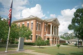
Perry is a city in Houston and Peach counties in the U.S. state of Georgia. It is the county seat of Houston County. The population was 13,839 at the 2010 census, up from 9,602 at the 2000 census. As of 2019 the estimated population was 17,894. It is part of the Warner Robins, Georgia metropolitan statistical area, within the Macon–Bibb County–Warner Robins combined statistical area.

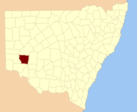
Perry County may refer to:

<span class="mw-page-title-main">Macdonald River (Bendemeer)</span> River in New South Wales, Australia

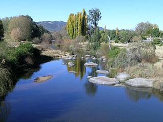
Macdonald River, a perennial river that is part of the Namoi catchment within the Murray–Darling basin, is located in the Northern Tablelands district of New South Wales, Australia.

<span class="mw-page-title-main">South Creek (New South Wales)</span> Creek in Sydney, Australia

The South Creek or Wianamatta is a creek that is part of the Hawkesbury-Nepean catchment, located on the Cumberland Plain in Greater Western Sydney, New South Wales, Australia.

The Geographical Names Board of New South Wales, a statutory authority of the Department of Customer Service in the Government of New South Wales, is the official body for naming and recording details of places and geographical names in the state of New South Wales, Australia.

James Meehan was an Irish Australian explorer and surveyor.

<span class="mw-page-title-main">Perry Township, Stark County, Ohio</span> Township in Ohio, United States

Perry Township is one of the seventeen townships of Stark County, Ohio, United States. It is an urban township; the 2020 census found 28,389 people in the township.

<span class="mw-page-title-main">Darbalara, New South Wales</span> Town in New South Wales, Australia

Darbalara is a rural community on the east bank of the junction of the Murrumbidgee River and Tumut River in the Riverina. It is situated by road, about 25 kilometres north east of Gundagai and 25 kilometres south of Coolac.

<span class="mw-page-title-main">Gloucester County, New South Wales</span> Cadastral in New South Wales, Australia

Gloucester County was one of the original Nineteen Counties in New South Wales, and is now one of the 141 cadastral divisions of New South Wales. It includes the area around Port Stephens. It is bounded on the north and west by the Manning River, and on the south-west by the Williams River.

<span class="mw-page-title-main">Northumberland County, New South Wales</span> Cadastral in New South Wales, Australia

Northumberland County was one of the original Nineteen Counties in New South Wales and is now one of the 141 Cadastral divisions of New South Wales. It included the area to the north of Broken Bay, which compasses the Central Coast region and Lake Macquarie as well as Newcastle(Greater Newcastle) in the Hunter region. It was bounded by the part of the Hawkesbury River to the south, the Macdonald River to the south-west, and the Hunter River to the north.

<span class="mw-page-title-main">Camden County, New South Wales</span> Cadastral in New South Wales, Australia

Camden County was one of the original Nineteen Counties in New South Wales and is now one of the 141 Cadastral divisions of New South Wales. It included the coastal area near Wollongong south to the Shoalhaven River, and also inland encompassing Berrima and Picton. Its western boundary was the Wollondilly River. The first settlement in the area was Camden Park, established by John Macarthur in 1806, just across the Nepean River from Cumberland County. It was the first land across the Nepean to be settled. Camden is a present-day suburb of Sydney in the same area, although parts of it are in Cumberland.

<span class="mw-page-title-main">St Vincent County</span> Cadastral in Australian Capital Territory

St Vincent County was one of the original Nineteen Counties in New South Wales and is now one of the 141 Cadastral divisions of New South Wales. It included the south coast area encompassing Batemans Bay, Ulladulla, Jervis Bay and inland to Braidwood. The Shoalhaven River is the boundary to the north and west, and the Deua River the boundary to the south.

<span class="mw-page-title-main">Cowper County</span> Cadastral in New South Wales, Australia

Cowper County, New South Wales is one of the 141 Cadastral divisions of New South Wales.

<span class="mw-page-title-main">Mootwingee County</span> Cadastral in New South Wales, Australia

Mootwingee County, New South Wales is one of the 141 cadastral divisions of New South Wales.

<span class="mw-page-title-main">Oxley County</span> Cadastral in New South Wales, Australia

Oxley County, New South Wales is one of the 141 Cadastral divisions of New South Wales. It is located between the Bogan River on the west, and the Macquarie River on the east. This is the area approximately between Warren and Nyngan.

<span class="mw-page-title-main">Bendemeer, New South Wales</span> Town in New South Wales, Australia

Bendemeer is a village of 485 people on the Macdonald River in the New England region of New South Wales, Australia. It is situated at the junction of the New England and Oxley Highways.

<span class="mw-page-title-main">Grose River</span> River in Australia

The Grose River, a perennial river that is part of the Hawkesbury-Nepean catchment, is located in the Blue Mountains region of New South Wales, Australia.

<span class="mw-page-title-main">Cobrabald River</span> River in New South Wales, Australia

Cobrabald River, a mostly perennial river that is part of the Namoi catchment within the Murray–Darling basin, is located in the Northern Tablelands district of New South Wales, Australia.

References

  1. "Perry". Geographical Names Register (GNR) of NSW. Geographical Names Board of New South Wales . Retrieved 7 August 2013. OOjs UI icon edit-ltr-progressive.svg