
Interstate 75 (I-75) is a major north–south Interstate Highway in the Great Lakes and Southeastern regions of the United States. As with most Interstates that end in 5, it is a major cross-country, north–south route, traveling from State Road 826 and SR 924 on the Hialeah–Miami Lakes border to Sault Ste. Marie, Michigan, at the Canadian border. It is the second-longest north–south Interstate Highway and the seventh-longest Interstate Highway overall.

Miami County is a county located in the U.S. state of Indiana. As of 2020, the population was 35,962. The county seat is the City of Peru. Miami County is part of the Kokomo-Peru CSA.

Perrysburg is a city located in Wood County, Ohio, United States, along the south side of the Maumee River. The population was 25,041 at the 2020 census. Part of the Toledo metropolitan area, the city is 12 miles (19 km) southwest of Toledo. Perrysburg served as the county seat from 1822 to 1868, and although it is currently the second-largest city in Wood County after Bowling Green, it is one of the fastest growing cities in Northwest Ohio and now the largest suburb of Toledo.
Perrysburg is a town in Cattaraugus County, New York, United States. The population was 1,515 at the 2020 census. The town is named after Commodore Oliver Hazard Perry and is located in the northwest corner of the county. The town contains the census-designated place also named Perrysburg, formerly an incorporated village.

The Maumee River is a river running in the United States Midwest from northeastern Indiana into northwestern Ohio and Lake Erie. It is formed at the confluence of the St. Joseph and St. Marys rivers, where Fort Wayne, Indiana has developed, and meanders northeastwardly for 137 miles (220 km) through an agricultural region of glacial moraines before flowing into the Maumee Bay of Lake Erie. The city of Toledo is located at the mouth of the Maumee. The Maumee was designated an Ohio State Scenic River on July 18, 1974. The Maumee watershed is Ohio's breadbasket; it is two-thirds farmland, mostly corn and soybeans. It is the largest watershed of any of the rivers feeding the Great Lakes, and supplies five percent of Lake Erie's water.

The Great Black Swamp was a glacially fed wetland in northwest Ohio and northeast Indiana, United States, that existed from the end of the Wisconsin glaciation until the late 19th century. Comprising extensive swamps and marshes, with some higher, drier ground interspersed, it occupied what was formerly the southwestern part of proglacial Lake Maumee, a Holocene precursor to Lake Erie. The area was about 25 miles (40 km) wide and 100 miles (160 km) long, covering an estimated 1,500 square miles (4,000 km2). Gradually drained and settled in the second half of the 19th century, it is now highly productive farmland. However, this development has been detrimental to the ecosystem as a result of agricultural runoff. This runoff, in turn, has contributed to frequent toxic algal blooms in Lake Erie.

State Route 795 is an east–west state highway in northwestern Ohio, a U.S. state. The western terminus of SR 795 is at US 20 in Perrysburg, at the signalized intersection that doubles as the northern terminus of SR 199. Its eastern terminus is at a signalized intersection with SR 51 about 0.5 miles (0.80 km) southeast of Millbury.

Northwest Ohio, or Northwestern Ohio, consists of multiple counties in the northwestern corner of the US state of Ohio. This area borders Lake Erie, Southeast Michigan, and northeastern Indiana. Some areas are also considered the Black Swamp area. The Toledo metropolitan area is part of the region.
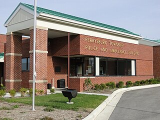
Perrysburg Township is one of the nineteen townships of Wood County, Ohio, United States. The 2020 census found 13,571 people in the township.

Miami Township is one of fourteen townships in Cass County, Indiana. As of the 2010 census, its population was 1,292.
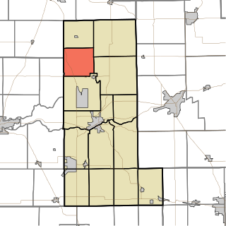
Union Township is one of fourteen townships in Miami County, Indiana, United States. As of the 2010 census, its population was 857 and it contained 363 housing units.
Birmingham is an unincorporated community in Allen Township, Miami County, in the U.S. state of Indiana.
Courter is an unincorporated community in Jefferson Township, Miami County, in the U.S. state of Indiana.
Deedsville is an unincorporated community in Union Township, Miami County, in the U.S. state of Indiana.
Chili (Cheye-leye) is an unincorporated community and census-designated place in Richland Township, Miami County, in the U.S. state of Indiana.
McGrawsville is an unincorporated community in Clay and Harrison townships, Miami County, in the U.S. state of Indiana.
Miami is an unincorporated community and census-designated place (CDP) in Deer Creek Township, Miami County, in the U.S. state of Indiana.
North Grove is an unincorporated community and census-designated place (CDP) in Harrison Township, Miami County, in the U.S. state of Indiana.
Bennetts Switch is an unincorporated community and census-designated place (CDP) in Deer Creek Township, Miami County, in the U.S. state of Indiana.
Leonda was a community, now extinct, in Pipe Creek Township, Miami County, in the U.S. state of Indiana.


