Petit Vignemale

Last updated
Petit Vignemale

Bayssellance Vignemale.JPG

Petit Vignemale (3032 m) au centre, col de la Hourquette d'Ossoue à droite (2 734 m), vue partielle du glacier d'Ossoue (Photo prise du col de Labas)
Highest point
Elevation 3,032 m (9,948 ft)
Prominence 70 metres (230 ft)
Listing List of Pyrenean three-thousanders
Coordinates 42°46′29″N0°08′05″E / 42.77472°N 0.13472°E / 42.77472; 0.13472 Coordinates: 42°46′29″N0°08′05″E / 42.77472°N 0.13472°E / 42.77472; 0.13472 [1]
Geography
Pyrenees topographic map-en.svg
Red triangle with thick white border.svg
Petit Vignemale
Location in the Pyrenees
Location Hautes-Pyrénées, France
Region Midi-Pyrénées
Parent range Massif du Vignemale (Pyrenees)
Geology
Age of rock Praguien - Emsien [2]
Climbing
First ascent August 1798 by La Baumelle

The Petit Vignemale is a summit in the French Pyrenees in the massif du Vignemale. Access is possible either by the Gaube valley (beyond Cauterêts), or la vallée d'Ossoue.

Pyrenees Range of mountains in southwest Europe

The Pyrenees is a range of mountains in southwest Europe that forms a natural border between Spain and France. Reaching a height of 3,404 metres (11,168 ft) altitude at the peak of Aneto, the range separates the Iberian Peninsula from the rest of continental Europe, and extends for about 491 km (305 mi) from the Bay of Biscay to the Mediterranean Sea.

Cauterets Commune in Occitanie, France

Cauterets is a spa town, a ski resort and a commune in the Hautes-Pyrénées department and the region of Occitanie in south-western France.

Contents

Toponymy

Vignemale is a tautological compound of two pre-Indo-European vin and mal both meaning « mountain ». [3]

Pre-Indo-European languages languages, not necessarily related to one another, that existed in prehistoric Europe and South Asia before the arrival of speakers of Indo-European languages

Pre-Indo-European languages are any of several ancient languages, not necessarily related to one another, that existed in prehistoric Europe and South Asia before the arrival of speakers of Indo-European languages. The oldest Indo-European language texts date from 19th century BCE in Kültepe in modern-day Turkey, and while estimates vary widely, spoken Indo-European languages are believed to have developed at the latest by the third millennium BCE. Thus the Pre-Indo-European languages must have developed earlier than, or in some cases alongside, the Indo-European languages that ultimately displaced them.

Geography

Le Petit Vignemale is located in the Hautes-Pyrénées department, near Cauterets and Gavarnie arrondissement of Argelès-Gazost in the Pyrenees National Park.

Hautes-Pyrénées Department of France

Hautes-Pyrénées is a department in southwestern France. It is part of the Occitanie region.

Gavarnie Part of Gavarnie-Gèdre in Occitanie, France

Gavarnie is a former commune in the Hautes-Pyrénées department in south-western France. On 1 January 2016, it was merged into the new commune of Gavarnie-Gèdre. Gavarnie is known for the Cirque de Gavarnie, and the Gavarnie Falls in it, part of the UNESCO World Heritage Site Pyrénées – Mont Perdu.

Argelès-Gazost Subprefecture and commune in Occitanie, France

Argelès-Gazost is a commune in the Hautes-Pyrénées department in southwestern France.

Geology

The summit is composed of sediment masses from the early Devonian period. [4]

Sediment Particulate solid matter that is deposited on the surface of land

Sediment is a naturally occurring material that is broken down by processes of weathering and erosion, and is subsequently transported by the action of wind, water, or ice or by the force of gravity acting on the particles. For example, sand and silt can be carried in suspension in river water and on reaching the sea bed deposited by sedimentation and if buried, may eventually become sandstone and siltstone.

The Devonian is a geologic period and system of the Paleozoic, spanning 60 million years from the end of the Silurian, 419.2 million years ago (Mya), to the beginning of the Carboniferous, 358.9 Mya. It is named after Devon, England, where rocks from this period were first studied.

Climbing

The first ascent was made in August 1798 by La Baumelle.

Access

Two routes :

Related Research Articles

The Montagnes Noires, also known as the Montagne Noire and in Breton as Menez Du are an east-west oriented range of hills in Brittany centred on the town of Gourin. They culminate in the peak of Roc de Toullaeron which attains a height of either 318m or 326m. Other significant peaks include Ar Menez (304m) and Montagne Noir (307m) . They are composed from a range of Precambrian, Ordovician, Silurian and Devonian rocks forming a part of the Variscan orogen and include sandstones, quartzites and slates.

Henry Russell (explorer) French mountaineer and explorer

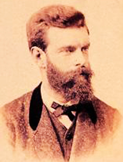
Henry Patrick Marie, Count Russell-Killough (1834–1909) was one of the pioneers of Pyrenean exploration, known for his obsession with the Vignemale.

Robert Arnauld dAndilly French writer

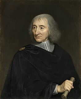
Robert Arnauld d’Andilly was a Frenchconseiller d’État, specialising in financial questions, in the court of Marie de' Medici. By the elegance of his language, he was among the major poets, writers and translators of 17th century French classicism. A fervent Catholic, he played an important role in the history of Jansenism and was one of the Solitaires of Port-Royal-des-Champs. He was also renowned for his part in the development of the pruning of fruit trees, to which he was devoted.

Neolithic flint mines of Spiennes Archaeological site in Belgium

The Neolithic flint mines of Spiennes are among the largest and earliest Neolithic flint mines which survive in north-western Europe, located close to the Walloon village of Spiennes, southeast of Mons, Belgium. The mines were active during the mid and late Neolithic between 4,300 and 2,200 BC. Declared to be "remarkable for the diversity of technological solutions used for extraction" the site and its surroundings were inducted into the UNESCO's list of World Heritage Sites in 2000.

Carrière des Nerviens Regional Nature Reserve

The Carrière des Nerviens Regional Nature Reserve is a protected area in the Nord-Pas-de-Calais region of northern France. It was established on 25 May 2009 to protect a site containing rare plants and covers just over 3 hectares. It is located in the municipalities of Bavay and Saint-Waast in the Nord department.

Bureau de Recherches Géologiques et Minières government agency

The Bureau de recherches géologiques et minières (BRGM) is the French government geological survey (EPIC) which aim is the management of resources, and surface and sub-surface risks.

Lavedan historical province of France

The Lavedan, or occasionally vallées des Gaves, denotes a mountainous natural region of France, located at the heart of the Pyrénées, and forms a group of valleys upstream of Lourdes.

Franz Schrader French geographer and painter

Jean Daniel François Schrader, better known as Franz Schrader, was a French mountaineer, geographer, cartographer and landscape painter, born in Bordeaux. He made an important contribution to the mapping of the Pyrenees and was highly considered among the pyreneists.

Pic de Montferrat mountain in France

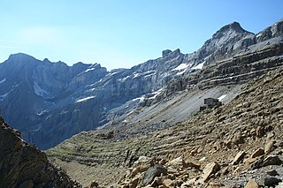
The Pic de Montferrat, culminating at 3,129 m (10,266 ft), is a crest summit on the Franco-Spanish border, in the massif du Vignemale in the Pyrenees.

Clot de la Hount mountain in France

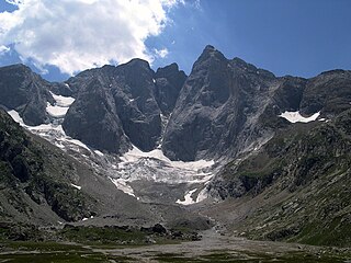
The Clot de la Hount or pic du clot de la Hount is a summit of the Pyrenees, located on the Franco-Spanish border in the Vignemale Massif, of which it is the second highest summit in the range, at 3,289 m, after Pique Longue.

Pic central mountain in France

The pic Central is a pyrenean summit, culminating at 3,235 m (10,614 ft), located on the Franco-Spanish border in the massif du Vignemale, of which it constitutes the fourth highest peak.

Tour du Marboré mountain in France

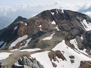
Tour du Marboré or Tour de Gavarnie is a pyrenean summit, culminating at 3,009 m (9,872 ft), located on the Franco-Spanish border crest in the Monte Perdido Range.

Piton Carré mountain in France

Le Piton Carré is a summit in the French Pyrenees in the Massif du Vignemale, of which it constitutes the seventh highest peak.

Pointe Chausenque mountain in France

La Pointe Chausenque, culminating at 3,204 m is a summit in the Massif du Vignemale in the French Pyrenees.

Cascade Peaks

The Cascade Peaks are three summits in the Monte Perdido Range of the Pyrenees, culminating at 3,161 m (10,371 ft) on the eastern peak. The central peak, known as Brulle, and the western peak are 3,106 m (10,190 ft) and 3,095 m (10,154 ft) high, respectively. The peaks are located on the 3,000 m French-Spanish borderline crest.

Pic de Montcalm mountain

Pic de Montcalm is a French pyrenean summit, culminating at 3,077 m (10,095 ft), located in the Ariège department, Midi-Pyrénées region of France.

COUPERIN is an academic consortium in France. Formed in 1999, it includes more than 250 universities, research organizations, Grandes écoles (schools), COMUE, and others. The consortium negotiates with publishers the prices and conditions of access to scientific publications and other digital resources for the benefit of its members. It promotes open science, particularly with regard to scientific publications, both nationally and internationally. It is headquartered in Paris.


Eugène de Malbos was a French Romantic painter known for his lithographs of the Pyrenees.

References

  1. Coordinates verified via WikiMapia
  2. Source : cartes géologiques à l'échelle 1:50000 du Bureau de recherches géologiques et minières (site en ligne).
  3. Albert Dauzat et al.Dictionnaire étymologique des noms de rivières et de montagnes en France, Lille, Editions Klincksieck, 1982
  4. Source : cartes géologiques à l'échelle 1:50000 du Bureau de recherches géologiques et minières (site en ligne).