Petrovo Brdo

Last updated
Petrovo Brdo
PetrovoBrdo1.jpg
Slovenia location map.svg
Red pog.svg
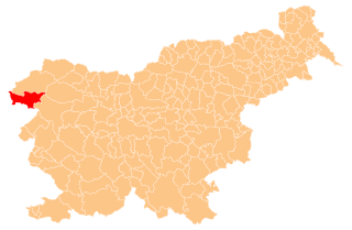
Petrovo Brdo
Location in Slovenia
Coordinates: 46°12′51.69″N13°59′55.57″E / 46.2143583°N 13.9987694°E / 46.2143583; 13.9987694 Coordinates: 46°12′51.69″N13°59′55.57″E / 46.2143583°N 13.9987694°E / 46.2143583; 13.9987694
Country Flag of Slovenia.svg Slovenia
Traditional region Slovenian Littoral
Statistical region Gorizia
Municipality Tolmin
Area
  Total 5.91 km2 (2.28 sq mi)
Elevation 796.6 m (2,613.5 ft)
Population (2002)
  Total 126
[1]

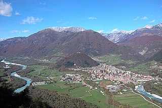
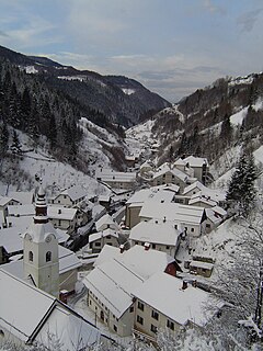
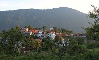
Petrovo Brdo (pronounced  [ˈpeːtɾɔʋɔ ˈbəɾdɔ] ) is a village in the Municipality of Tolmin in the Littoral region of Slovenia on the border with the Upper Carniola region. [2]

Village Small clustered human settlement smaller than a town

A village is a clustered human settlement or community, larger than a hamlet but smaller than a town, with a population ranging from a few hundred to a few thousand. Though villages are often located in rural areas, the term urban village is also applied to certain urban neighborhoods. Villages are normally permanent, with fixed dwellings; however, transient villages can occur. Further, the dwellings of a village are fairly close to one another, not scattered broadly over the landscape, as a dispersed settlement.

Tolmin Town in Slovenian Littoral, Slovenia

Tolmin is a small town in northwestern Slovenia. It is the administrative centre of the Municipality of Tolmin.

Slovenia republic in Central Europe

Slovenia, officially the Republic of Slovenia, is a sovereign state located in southern Central Europe at a crossroads of important European cultural and trade routes. It is bordered by Italy to the west, Austria to the north, Hungary to the northeast, Croatia to the southeast, and the Adriatic Sea to the southwest. It covers 20,273 square kilometers (7,827 sq mi) and has a population of 2.07 million. One of the successor states of the former Yugoslavia, Slovenia is a parliamentary republic and a member of the United Nations, of the European Union, and of NATO. The capital and largest city is Ljubljana.

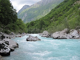
It lies on the road just below a pass that connects the two regions, on the drainage divide between the Bača River, which eventually flows into the Soča, and the Sora River, a tributary of the Sava River. The road through the settlement was an important throughway in the late Middle Ages. Between the First and Second World Wars, Petrovo Brdo was on the border between the Kingdom of Italy and the Kingdom of Yugoslavia and large border barracks were built there by the Italians.

Drainage divide Elevated terrain that separates neighbouring drainage basins

A drainage divide, water divide, divide, ridgeline, watershed, water parting or height of land is elevated terrain that separates neighbouring drainage basins. On rugged land, the divide lies along topographical ridges, and may be in the form of a single range of hills or mountains, known as a dividing range. On flat terrain, especially where the ground is marshy, the divide may be harder to discern.

Bača (river) river in Slovenia

The Bača is a river in northwestern Slovenia with a length of 22 km (14 mi). It runs from Bača pri Podbrdu to Bača pri Modreju, where it joins the Idrijca River as its last right tributary. It has the pluvio-nival regime and belongs to the Adriatic Sea Basin.

Soča river flows through western Slovenia and northeastern Italy

The Soča or Isonzo is a 138-kilometre (86 mi) long river that flows through western Slovenia and northeastern Italy.

Related Research Articles

Kobarid Place in Slovenian Littoral, Slovenia

Kobarid is a settlement in Slovenia, the administrative centre of the Municipality of Kobarid.

Bovec Place in Slovenian Littoral, Slovenia

Bovec is a town in the Littoral region in northwestern Slovenia, close to the border with Italy. It is the central settlement of the Municipality of Bovec.

Princely County of Gorizia and Gradisca Crown land of the empire of Austria

The Princely County of Gorizia and Gradisca was a crown land of the Habsburg dynasty within the Austrian Littoral on the Adriatic Sea, in what is now a multilingual border area of Italy and Slovenia. It was named for its two major urban centers, Gorizia and Gradisca d'Isonzo.

Podbrdo, Tolmin Place in Slovenian Littoral, Slovenia

Podbrdo is a settlement in the Municipality of Tolmin in the Littoral region of Slovenia. It lies in narrow valley of the Bača River, next to the Bohinj Railway line at the end of the longest railway tunnel in Slovenia and next to the road from Bohinjska Bistrica and Železniki across Petrovo Brdo towards Most na Soči.

Brdo may refer to:

Golo Brdo, Brda Place in Slovenian Littoral, Slovenia

Golo Brdo is a small village in the Municipality of Brda in the Littoral region of Slovenia, right on the border with Italy.

Bača pri Modreju Place in Slovenian Littoral, Slovenia

Bača pri Modreju is a village in the Municipality of Tolmin in the Littoral region of Slovenia. It lies at the confluence of the Bača River with the Idrijca River, which in turn joins the Soča River at Most na Soči, northwest of the settlement. The village includes the hamlets of Grapa, Stopec, and Sopotnica.

Obloke Place in Slovenian Littoral, Slovenia

Obloke is a small village on the right bank of the Bača River in the Municipality of Tolmin in the Littoral region of Slovenia.

Pečine Place in Slovenian Littoral, Slovenia

Pečine is a village in the mountains above the right bank of the Idrijca River in the municipality of Tolmin in the Littoral region of Slovenia. It includes the hamlets of Črni Vrh, Kabiunk, Kal, Maraževec, Podkal, Travnik, and Stari Rut.

Prapetno Brdo Place in Slovenian Littoral, Slovenia

Prapetno Brdo is a dispersed settlement in the Municipality of Tolmin in the Littoral region of Slovenia. It lies west of Šentviška Gora on the southern slopes of the mountains to the north of the Idrijca Valley. It includes the hamlets of Trata, Dolina, Golubovc, and Sleme.

Volarje Place in Slovenian Littoral, Slovenia

Volarje is a village on the left bank of the Soča River in the Municipality of Tolmin in the Littoral region of Slovenia.

Volčanski Ruti Place in Slovenian Littoral, Slovenia

Volčanski Ruti is a dispersed settlement in the hills to the south of Volče in the Municipality of Tolmin in the Littoral region of Slovenia, close to the border with Italy.

Volče, Tolmin Place in Slovenian Littoral, Slovenia

Volče is a settlement on the right bank of the Soča River in the Municipality of Tolmin in the Littoral region of Slovenia, close to the border with Italy.

Gorizia Statistical Region Statistical region

The Gorizia Statistical Region is a statistical region in western Slovenia, along the border with Italy. It is named after the Italian town of Gorizia. The Julian Alps, the Soča River, and the Vipava Valley are the most prominent natural features of this region. It contributed just over 5% to total national GDP in 2012, but in terms of GDP per capita it ranked fourth in the country. In the same year, disposable income per capita in the region the highest, in second place behind the Central Slovenia Statistical Region. Housing stock estimates indicate that at the end of 2013 the region had the highest share of dwellings with three or more rooms. The share of single-room dwellings was less than 10%. Dwellings here are larger than the Slovenian average, with 37 m² of usable floor space per person on average. The number of cars per 1,000 population is also the highest in Slovenia, with an average of 100 cars more per 1,000 people than in the Central Sava Statistical Region. However, the cars here and in the Lower Sava Statistical Region are also the oldest.

Kolovrat (mountain ridge) mountain

Kolovrat is a mountain ridge of the Julian Prealps on the border between Slovenia and Italy, west of Tolmin and southeast of Kobarid. It is a geographical border between the Soča Valley in Slovenia and the Venetian Slovenia region of Italy. It extends about 7 km at an elevation between 800 and 1150 m.

Porezen mountain in Slovenia

Mount Porezen is a mountain of the outlying Alps located in Slovenia. It is the highest summit of the Slovenian Prealps.

Municipality of Tolmin Municipality in Slovenia

The Municipality of Tolmin is a municipality in northwestern Slovenia. Its centre and the largest settlement is Tolmin.

Municipality of Kobarid Municipality in Slovenia

The Municipality of Kobarid is a municipality in the Upper Soča Valley in western Slovenia, near the Italian border. The seat of the municipality is the town of Kobarid. The municipality was established on 3 October 1994, when the former larger Municipality of Tolmin was subdivided into the municipalities of Bovec, Kobarid, and Tolmin.

Hinjce Place in Lower Carniola, Slovenia

Hinjce is a small village in the Municipality of Sevnica in southeastern Slovenia. It lies on a small rise east of Krmelj and west of the Mirna River and the village of Brezje. Until 2006, the area was part of the settlement of Goveji Dol. The village is part of the traditional region of Lower Carniola and is included in the Lower Sava Statistical Region. One of the two roads from Krmelj to the main road linking Mokronog and Sevnica runs through the settlement.

References