Dolenja Trebuša

Last updated
Dolenja Trebuša
Dolenja Trebusa - panoramio.jpg
Slovenia location map.svg
Red pog.svg
Dolenja Trebuša
Location in Slovenia
Coordinates: 46°5′38.21″N13°50′20.04″E / 46.0939472°N 13.8389000°E / 46.0939472; 13.8389000 Coordinates: 46°5′38.21″N13°50′20.04″E / 46.0939472°N 13.8389000°E / 46.0939472; 13.8389000
Country Flag of Slovenia.svg Slovenia
Traditional region Slovenian Littoral
Statistical region Gorizia
Municipality Tolmin
Area
  Total 22.15 km2 (8.55 sq mi)
Elevation 189 m (620 ft)
Population (2002)
  Total 274
[1]

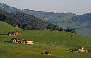
Dolenja Trebuša (pronounced  [dɔˈleːnja tɾɛˈbuːʃa] ) is a dispersed settlement in the municipality of Tolmin in the Littoral region of Slovenia. It lies in the Idrijca Valley, surrounded by mountain plateaus. [2]

Dispersed settlement Rural settlement type, typically consists of widely spaced farmsteads without an actual nucleus

A dispersed settlement, also known as a scattered settlement, is one of the main types of settlement patterns used by landscape historians to classify rural settlements found in England and other parts of the world. Typically, there are a number of separate farmsteads scattered throughout the area. A dispersed settlement contrasts with a nucleated village.

Tolmin Town in Slovenian Littoral, Slovenia

Tolmin is a small town in northwestern Slovenia. It is the administrative centre of the Municipality of Tolmin.

Slovenia republic in Central Europe

Slovenia, officially the Republic of Slovenia, is a sovereign state located in southern Central Europe at a crossroads of important European cultural and trade routes. It is bordered by Italy to the west, Austria to the north, Hungary to the northeast, Croatia to the southeast, and the Adriatic Sea to the southwest. It covers 20,273 square kilometers (7,827 sq mi) and has a population of 2.07 million. One of the successor states of the former Yugoslavia, Slovenia is a parliamentary republic and a member of the United Nations, of the European Union, and of NATO. The capital and largest city is Ljubljana.

The parish church in the settlement is dedicated to Saint James and belongs to the Koper Diocese. [3]

Parish church church which acts as the religious centre of a parish

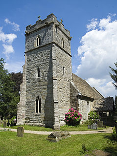
A parish church in Christianity is the church which acts as the religious centre of a parish. In many parts of the world, especially in rural areas, the parish church may play a significant role in community activities, often allowing its premises to be used for non-religious community events. The church building reflects this status, and there is considerable variety in the size and style of parish churches. Many villages in Europe have churches that date back to the Middle Ages, but all periods of architecture are represented.

James, son of Zebedee One of JesusTwelve Apostles

James, son of Zebedee was one of the Twelve Apostles of Jesus, traditionally considered the first apostle to be martyred.

Koper City in Slovenian Littoral, Slovenia

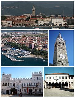
Koper is the fifth largest city in Slovenia. Located in the southwestern part of the country, approximately five kilometres south of the border with Italy and 20 kilometers from Trieste, Koper is the largest coastal city in the country. It is bordered by the satellite towns of Izola and Ankaran, and anchors the Istrian region. With a unique ecology and biodiversity, it is considered an important national natural resource. It is the oldest recorded urban settlement in Slovenia. The city's Port of Koper is the major contributor to the economy of the eponymous city municipality. With only one percent of Slovenia having a coastline, the influence that the Port of Koper also has on tourism was a factor in Ankaran deciding to leave the municipality in a referendum in 2011 to establish its own. The city is a destination on a number of Mediterranean cruising lines. In 2016, the city expects 65 cruise ship arrivals with the season spanning from March to December. Koper is the main urban centre of the Slovenian Istria, with a population of about 25,000.

Related Research Articles

Levpa in Littoral, Slovenia

Levpa is a dispersed settlement in the hills to the east of Kanal in the Littoral region of Slovenia. It lies on the northwest part of the Banjšice Plateau and is made up of several smaller settlements: Bizjaki, Dolenja Levpa, Gorenja Levpa, Hoje, Mešnjak, Košenija, Robi, Sukavec, Testeni, and Zavrh.

Bača pri Podbrdu in Slovenian Littoral, Slovenia

Bača pri Podbrdu is a dispersed settlement above Podbrdo in the Municipality of Tolmin in the Littoral region of Slovenia. It lies on the southern slopes of Mount Kobla and is a popular starting point for hiking trips into the surrounding peaks of the southern Julian Alps.

Idrija pri Bači in Slovenian Littoral, Slovenia

Idrija pri Bači is a village on the right bank of the Idrijca River in the Municipality of Tolmin in the Littoral region of Slovenia.

Kamno, Tolmin in Slovenian Littoral, Slovenia

Kamno is a village on the left bank of the Soča River in the Municipality of Tolmin in the Littoral region of Slovenia.

Kanalski Lom in Slovenian Littoral, Slovenia

Kanalski Lom is a village in the hills south of Most na Soči in the Municipality of Tolmin in the Littoral region of Slovenia.

Kozaršče in Slovenian Littoral, Slovenia

Kozaršče is a small village northwest of Most na Soči in the Municipality of Tolmin in the Littoral region of Slovenia.

Ljubinj in Slovenian Littoral, Slovenia

Ljubinj is a settlement southeast of Tolmin in the Littoral region of Slovenia.

Logaršče Place in Slovenian Littoral, Slovenia

Logaršče is a dispersed settlement in the hills south of the Bača Valley in the Municipality of Tolmin in the Littoral region of Slovenia.

Loje in Slovenian Littoral, Slovenia

Loje is small settlement in the hills north of Kneža in the Municipality of Tolmin in the Littoral region of Slovenia.

Obloke Place in Slovenian Littoral, Slovenia

Obloke is a small village on the right bank of the Bača River in the Municipality of Tolmin in the Littoral region of Slovenia.

Podmelec Place in Slovenian Littoral, Slovenia

Podmelec is a village west of Kneža in the Bača Valley in the Municipality of Tolmin in the Littoral region of Slovenia.

Rut, Tolmin Place in Slovenian Littoral, Slovenia

Rut is a village north of Koritnica in the Municipality of Tolmin in the Littoral region of Slovenia.

Stržišče, Tolmin in Slovenian Littoral, Slovenia

Stržišče is a settlement in the hills north of Hudajužna in the Municipality of Tolmin in the Littoral region of Slovenia.

Šentviška Gora in Slovenian Littoral, Slovenia

Šentviška Gora is the main settlement in the hills between the valleys of the Bača and Idrijca rivers, known as the St. Vitus Plateau or Šentviška Gora Plateau, in the Municipality of Tolmin in the Littoral region of Slovenia.

Volarje in Slovenian Littoral, Slovenia

Volarje is a village on the left bank of the Soča River in the Municipality of Tolmin in the Littoral region of Slovenia.

Volčanski Ruti in Slovenian Littoral, Slovenia

Volčanski Ruti is a dispersed settlement in the hills to the south of Volče in the Municipality of Tolmin in the Littoral region of Slovenia, close to the border with Italy.

Volče, Tolmin in Slovenian Littoral, Slovenia

Volče is a settlement on the right bank of the Soča River in the Municipality of Tolmin in the Littoral region of Slovenia, close to the border with Italy.

Zatolmin Place in Slovenian Littoral, Slovenia

Zatolmin is a settlement north of Tolmin in the Littoral region of Slovenia.

Žabče Place in Slovenian Littoral, Slovenia

Žabče is a village northeast of Tolmin in the Littoral region of Slovenia.

Planina, Ajdovščina Place in Littoral, Slovenia

Planina is a village in the hills south of the Vipava Valley on the border with the Karst Plateau in the Municipality of Ajdovščina in the Littoral region of Slovenia. It is made up of smaller clusters of the hamlets of Štrancarji, Marci, Dolenja Vas, Brithi, Gorenja Vas, and Koboli.

References