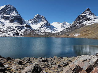
Patilla Pata is a stratovolcano in the Oruro Department in Bolivia. It is situated in the Sajama Province, in the west of the Curahuara de Carangas Municipality, at the border with Chile. Patilla Pata lies south-west of the mountain Jisk'a Kunturiri, north-east of the lake Q'asiri Quta (Khasiri Kkota) and the mountain Qullqi Warani, west of the little lake Sura Pata, south-east of the mountains Laram Q'awa, Kunturiri and Milluni and south of the little lake named Ch'iyar Quta.

Pacajes is a province in the Bolivian department of La Paz. Its capital is Coro Coro.
Sajama is a province in the northwestern parts of the Bolivian Oruro Department.
Calacoto or Qala Qutu is the third municipal section of the Pacajes Province in the La Paz Department, Bolivia. Its seat is Calacoto.

Charaña Municipality is the fifth municipal section of the Pacajes Province in the La Paz Department, Bolivia. Its seat is Charaña.

Ch'iyar Quta is a small Bolivian lake located in the Sajama Province of the Oruro Department near the border to Chile. It is situated at a height of about 5,090 meters inside the boundaries of the Sajama National Park. Ch'iyar Quta lies south-east of the peaks of Laram Q'awa, Milluni and Kunturiri, south-west of Jisk'a Kunturiri and north of Patilla Pata.
Laram Q'awa is a 5,182-metre-high (17,001 ft) mountain in the Andes. According to the Bolivian IGM map 1:50,000 'Nevados Payachata Hoja 5739-I' it is situated on Bolivian terrain in the La Paz Department, Pacajes Province, at the border with Chile. It lies north-west of the mountains Kunturiri, Phaq'u Q'awa and another mountain on the border named Laram Q'awa (Laram Khaua). One of three different rivers of this area called Kunturiri (Condoriri) originates north-east of the mountain near Phaq'u Q'awa. It flows in a bow along the northern slopes of Laram Q'awa towards Chile.

Kunturiri is a volcano in the Andes on the border of Bolivia and Chile which rises up to 5,762 metres (18,904 ft). On the Chilean side it is located in the Arica and Parinacota Region and on the Bolivian side in the Oruro Department, Sajama Province, Curahuara de Carangas Municipality, Sajama Canton as well as in the La Paz Department, Pacajes Province, Calacoto Municipality, Ulloma Canton.

Phaq'u Quta is a lake in Bolivia located in the La Paz Department, Pedro Domingo Murillo Province, El Alto Municipality. It is situated at a height of about 4,667 metres (15,312 ft) south of the mountain Chacaltaya, south-east of Milluni Lake and south-west of Qillwani (Khelluani).

Janq'u Uyu is a mountain in the Andes, about 5,512 m (18,084 ft) high, located in the Cordillera Real of Bolivia in the La Paz Department, Los Andes Province, Batallas Municipality, Chachakumani Canton on the border with Larecaja Province, Guanay Municipality, Challana Canton. It is situated at the very end of the Janq'u Quta valley between Jisk'a Pata in the north-west and Wila Lluxita in the east, north of Wila Lluxi and Phaq'u Kiwuta.
Wila Qullu is a mountain in the Bolivian Andes, about 4,600 metres (15,092 ft) high. It situated in the Cordillera Occidental near the border with Chile. It is located in the Oruro Department, Sabaya Province, Sabaya Municipality, Julo Canton. Wila Qullu lies south-east of the volcano Pukintika and north-west of the mountain Phaq'u Q'awa.
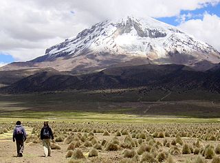
Asu Asuni is a 5,088-metre-high (16,693 ft) mountain in a volcanic complex in the Cordillera Occidental in the Andes of Bolivia. It is located in the Oruro Department, Sajama Province, Turco Municipality, Turco Canton. It is situated southeast of the extinct Sajama volcano (3 km), between the Chullkani volcano in the west (3 km) and Turco in the east, at the National Route 27.
Qala T'uxu or Qala Tuqu is a mountain in the Cordillera Real in the Andes of Bolivia, about 5,076 metres (16,654 ft) high. It is located in the La Paz Department, Los Andes Province, Batallas Municipality, Chachacomani Canton. It is situated south-west of the mountains Wila Lluxi and Warawarani and north-west of the mountain Phaq'u Kiwuta.
Pumuta is a mountain in the Andes of Bolivia, about 5,200 metres (17,060 ft) high. It is situated in the Oruro Department, Sajama Province, Curahuara de Carangas Municipality, Sajama Canton, north-west of the extinct Sajama volcano. Pumuta lies south-west of the mountain Jach'a Kunturiri and north-east to east of the mountains Kunturiri and Jisk'a Kunturiri.

Qullqi Warani is a mountain in the Oruro Department in Bolivia at the border with Chile, north-west of the extinct Sajama volcano. It is situated in the Sajama Province, in the west of the Curahuara de Carangas Municipality. According to the Bolivian IGM map 1:50,000 'Nevados Payachata Hoja 5739-I' it lies entirely on Bolivian terrain. Qullqi Warani lies south-west of the mountains Jisk'a Kunturiri and Patilla Pata, north of Phaq'u Q'awa and south-east of Kunturiri. The little lakes Q'asiri Quta (Khasiri Kkota) and Sura Pata (Sora Pata, Sorapata) lie at its feet, east and north of it.
Phaq'u Q'awa is a mountain in the Cordillera Occidental in the Andes of Bolivia, about 5,380 metres (17,651 ft) high. It is situated in the Oruro Department, Sajama Province, in the west of the Curahuara de Carangas Municipality, northwest of the extinct Sajama volcano. It lies south of Qullqi Warani.
Wila Qullu is a mountain in the Oruro Department in the Andes of Bolivia, about 5,140 metres (16,864 ft) high. Wila Qullu is situated in the Sajama Province, in the west of the Curahuara de Carangas Municipality, west of the extinct Sajama volcano and north-east of the Paya Chata mountains. It lies south-west of the mountain Phaq'u Q'awa.
Phaq'u Q'awa is a 5,203-metre-high (17,070 ft) mountain in the Cordillera Occidental in the Andes of Bolivia. It is situated in the Oruro Department, Sabaya Province, Sabaya Municipality. Phaq'u Q'awa lies southeast of Wila Qullu.
Wayra Lupi Qullu is a 4,732-metre-high (15,525 ft) mountain in the Andes of Bolivia. It is located in the La Paz Department, Pacajes Province, Charaña Municipality. It lies at the river Phaq'u Q'awa which later is named Achuta. Wayra Lupi Qullu is situated east of the mountains Ch'iyara Salla and Kunturiri.
Laram Q'awa is a 4,996-metre-high (16,391 ft) mountain in the Andes of Bolivia. It is situated in the La Paz Department, Pacajes Province, Charaña Municipality, north-west of Río Blanco. An intermittent stream which downstream is named Jach'a Uma originates near the mountain. It flows to Achuta River in the south-east.