
The Story Bridge is a heritage-listed steel cantilever bridge spanning the Brisbane River that carries vehicular, bicycle and pedestrian traffic between the northern and the southern suburbs of Brisbane, Queensland, Australia. It is the longest cantilever bridge in Australia.

Phillip Island is an Australian island about 125 km (78 mi) south-southeast of Melbourne, Victoria. The island is named after Governor Arthur Phillip, the first Governor of New South Wales, by explorer and seaman George Bass, who sailed in a whaleboat, arriving from Sydney on 5 January 1798.

The Hong Kong–Zhuhai–Macau Bridge (HZMB) is a 55-kilometre (34 mi) bridge–tunnel system consisting of a series of three cable-stayed bridges, an undersea tunnel, and four artificial islands. It is both the longest sea crossing and the longest open-sea fixed link in the world. The HZMB spans the Lingding and Jiuzhou channels, connecting Hong Kong and Macau with Zhuhai— a major city on the Pearl River Delta in China.

The Bass Coast Shire is a local government area in Victoria, Australia, located in the southeastern part of the state. It covers an area of 866 square kilometres (334 sq mi) and in June 2018 had a population of 35,327. It includes the towns of Bass, Cape Paterson, Cape Woolamai, Corinella, Coronet Bay, Cowes, Inverloch, Kilcunda, Lang Lang, Newhaven, Rhyll, San Remo, Summerlands and Wonthaggi as well as the historic locality of Krowera. It also includes the popular tourist destination Phillip Island. It was formed in 1994 from the amalgamation of the Shire of Bass, Shire of Phillip Island, Borough of Wonthaggi, parts of the Shire of Woorayl, Shire of Korumburra and City of Cranbourne.
Highway 1 is a provincial highway in British Columbia, Canada, that carries the main route of the Trans-Canada Highway (TCH). The highway is 1,047 kilometres (651 mi) long and connects Vancouver Island, the Greater Vancouver region in the Lower Mainland, and the Interior. It is the westernmost portion of the main TCH to be numbered "Highway 1", which continues through Western Canada and extends to the Manitoba–Ontario boundary. The section of Highway 1 in the Lower Mainland is the second-busiest freeway in Canada, after Ontario Highway 401 in Toronto.

The Port of Melbourne is the largest port for containerised and general cargo in Australia. It is located in Melbourne, Victoria, and covers an area at the mouth of the Yarra River, downstream of Bolte Bridge, which is at the head of Port Phillip, as well as several piers on the bay itself. Since 1 July 2003, the Port of Melbourne has been managed by the Port of Melbourne Corporation, a statutory corporation created by the State of Victoria.

Pamban Bridge is a railway bridge that connects the town of Mandapam in mainland India with Rameswaram on Pamban Island. Opened on 24 February 1914, it was India's first sea bridge, and was the longest sea bridge in India until the opening of the Bandra-Worli Sea Link in 2010. The rail bridge is, for the most part, a conventional bridge resting on concrete piers but has a double-leaf bascule section midway, which can be raised to let ships and barges pass through. Until 1988, the Pamban bridge was the only surface transport that connected Tamil Nadu's island of Rameswaram to the mainland India. On 23 December 2022, the bascule of this bridge was damaged due to extreme corrosion and so the sensors gave continuous warning signal which suspended transportation on the bridge permanently. The last train which officially ran on this bridge was Train no. 07695 Secunderabad - Rameswaram Special Express, which completed its commercial journey on the previous day. In February 2023, the Southern Railway announced that the train traffic to Rameshwaram through Pamban bridge has been completely stopped and will be restored through the new Pamban bridge after its completion.

The Hercílio Luz Bridge, located in Florianópolis, the capital city of Santa Catarina State in southern Brazil, is the first bridge constructed to link the Island of Santa Catarina to the mainland.

USS Gleaves (DD-423) was the lead ship of the Gleaves class of destroyers. She is the only ship of the United States Navy to be named for Admiral Albert Gleaves, who is credited with improving the accuracy and precision of torpedoes and other naval arms.
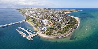
San Remo is a town in southern Victoria, Australia in the Gippsland region. Formed as a fishing village, its economy is now largely based on tourism. It is also notable as the town on the mainland end of the Phillip Island Bridge to Phillip Island. At the 2021 census, San Remo had a population of 1,700.

Newhaven is a town in southern Victoria, in the south Gippsland region. Located on Phillip Island, adjacent to the channel known as The Narrows, it is the town on the island side of the bridge linking Phillip Island to the mainland. At the 2021 census, Newhaven had a population of 547.
Kilcunda is a seaside town located 117 kilometres (73 mi) south east of Melbourne between Phillip Island and Wonthaggi near Dalyston via the South Gippsland Highway on the Bass Highway, in the Bass Coast Shire of Gippsland, Victoria, Australia. Known originally as a train station near Wonthaggi, it is now the location of a very popular swimming hole at the Bourne Creek Trestle Bridge and at the 2016 census, Kilcunda had a population of 396.

The Golden Gate International Exposition (GGIE) (1939 and 1940), held at San Francisco's Treasure Island, was a World's Fair celebrating, among other things, the city's two newly built bridges. The San Francisco–Oakland Bay Bridge opened in 1936 and the Golden Gate Bridge in 1937. The exposition opened from February 18, 1939, through October 29, 1939, and from May 25, 1940, through September 29, 1940; it drew 17 million visitors to Treasure Island.

Princes Bridge, originally Prince's Bridge, is a bridge in central Melbourne, Australia that spans the Yarra River. It is built on the site of one of the oldest river crossings in the city, and forms a gateway into the central city from the south. The bridge connects Swanston Street on the north bank of the Yarra River to St Kilda Road on the south bank, and carries road, tram and pedestrian traffic. The present bridge was built in 1888 and is listed on the Victorian Heritage Register.

South Gippsland, a region of Gippsland in Victoria, Australia, is a well-watered region consisting of low, rolling hills descending to the coast in the south and the Latrobe Valley in the north. Low granite hills continue into Wilsons Promontory, the southernmost point of Victoria and mainland Australia. Rivers are generally very short and impossible to dam owing to the lack of potential storage sites, but groundwater of good quality is readily available. The major industries are forestry and dairy farming, and the principal towns include Cowes, Leongatha, Korumburra, Wonthaggi and Foster.
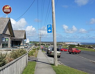
Phillip Island Road is a tourist highway in Victoria, Australia and branches off the Bass Highway at the township of Anderson. Previously assigned State Route 186, it was later designated B420. It was named due to the Phillip Island Bridge which opened in San Remo on the 21 November 1969.

The Shire of Bass was a local government area about 120 kilometres (75 mi) south-southeast of Melbourne, the state capital of Victoria, Australia. The shire covered an area of 526 square kilometres (203.1 sq mi), and existed from 1871 until 1994.

Churchill Island is a 50.7-hectare (125.3-acre) island in Western Port, Victoria, Australia. It is connected by a bridge to Phillip Island, which is in turn connected to the mainland by another bridge. It is the site of the first European garden in Victoria. It contains a working farm, cottages dating from the 1860s and a homestead dating from 1872, all fully restored and open to the public. The island adjoins the 670-hectare (1,656-acre) Churchill Island Marine National Park. The island is maintained by Phillip Island Nature Parks.

Dalyston is a seaside town located 125 kilometres (78 mi) south east of Melbourne via the South Gippsland and Bass Highways, in the Bass Coast Shire of Gippsland, Victoria, Australia. Known originally as a train station at Powlett River near Wonthaggi, it is now the location of the Victorian Desalination Plant, and at the 2011 census, it had a population of 606. It's Bass Coast’s fastest-growing suburb, with the 2011 census showing Dalyston’s population more than doubled from 278 residents in 2006 to 606 in 2011.

Rosie the Shark is a preserved great white shark located at Crystal World Exhibition Centre in Devon Meadows, Australia. She was originally preserved in a glass tank of formaldehyde on display at Wildlife Wonderland in Bass, Victoria which closed in 2012 due to animal welfare concerns and operating without appropriate licences.

