
The Arctic Archipelago, also known as the Canadian Arctic Archipelago, is an archipelago lying to the north of the Canadian continental mainland, excluding Greenland.

Ponoka is a town in central Alberta, Canada. It is located at the junction of Highway 2A and Highway 53, 59 kilometres (37 mi) north of Red Deer and 95 kilometres (59 mi) south of Edmonton.
Blackfalds is a town in central Alberta, Canada. It is located along Highway 2A 13.5 km north of Red Deer. The town's name, Waghorn, changed in 1903 to Blackfalds, after Blackfalds, a Scottish hamlet.

Escacena del Campo is a town and municipality located in the province of Huelva, Spain. According to the 2005 census, the municipality has a population of 2,182 inhabitants.
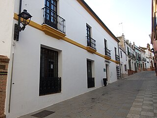
Manzanilla is a town and municipality located in the province of Huelva, Spain. According to the 2005 census, it has a population of 2,384 inhabitants.

The Morant Cays is an offshore island group 51 km SSE off Morant Point, Jamaica. It is one of two offshore island groups belonging to Jamaica, the other one is the Pedro Cays. They are located at 17°24′N75°59′W and consist of four small islets grouped closely together along the southeastern rim of Morant Bank a comparatively extensive crescent-shaped bank of coral, over 7 km long, rising from 1000 m. The area of Morant Bank is about 100 km2. The aggregate land area of the four cays is only 16.0 hectares or 39.5 acres. The Morant Cays are low-lying, mostly uninhabited, seasonally visited by fishermen, and fronted by highly exposed reefs over which the sea constantly breaks.
Blue Ridge is a hamlet in northwest Alberta, Canada within Woodlands County. It is located on Highway 658, 7 kilometres (4.3 mi) north of Highway 43 and 3 kilometres (1.9 mi) south of the Athabasca River. It is midway between the towns of Whitecourt and Mayerthorpe and approximately 159 kilometres (99 mi) northwest of Edmonton.

The Pacific Remote Islands Marine National Monument is a group of unorganized, mostly unincorporated United States Pacific Island territories managed by the United States Fish and Wildlife Service of the United States Department of the Interior and the National Oceanic and Atmospheric Administration (NOAA) of the United States Department of Commerce. These remote refuges are "the most widespread collection of marine- and terrestrial-life protected areas on the planet under a single country's jurisdiction". They protect many endemic species including corals, fish, shellfish, marine mammals, seabirds, water birds, land birds, insects, and vegetation not found elsewhere.

Naicam is a small town in rural Saskatchewan. It is located 224 km (139 mi) north of the province's capital city, Regina. In 2006 the population was 690. The name of the town is a combination of Naismith and Cameron, the railway construction contractors.
Jaumave is a town and a municipality located in the Mexican state of Tamaulipas.
The O'Chiese First Nation is a Saulteaux First Nation in Alberta, Canada. The First Nation's homeland is the 14,131.9 ha O'Chiese 203 Indian reserve, located approximately 52 km northwest of Rocky Mountain House. Also reserved is the O'Chiese Cemetery 203A. As of November 2013, the First Nation had the population of 1,250 registered people, of which the on-reserve population was 831 people. The primary language spoken on the reserve is the Western Ojibwa language. Though the ancestors of O'Chiese First Nation made the area about Baptiste River their winter camp site where they hunted moose and deer, and trapped small game for the fur trade, they also migrated as far south as the Milk River in Montana in the summer.
The Birch Mountains kimberlite field is a cluster of kimberlitic volcanic pipes or diatremes in north-central Alberta, Canada that were emplaced during a period of kimberlitic volcanism in the Late Cretaceous epoch. As of 2011, 8 diatremes had been discovered in the field, and diamonds and microdiamononds had been recovered during sampling programs.
This is a list of the extreme points and extreme elevations in Wales.
Zarzyń is a village in the administrative district of Gmina Sulęcin, within Sulęcin County, Lubusz Voivodeship, in western Poland. It lies approximately 22 kilometres (14 mi) east of Sulęcin, 41 km (25 mi) south of Gorzów Wielkopolski, and 50 km (31 mi) north of Zielona Góra.
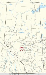
O'Chiese 203 is an Indian reserve in Alberta, Canada and is one of two reserves under the administration of the O'Chiese First Nation, a Saulteaux government. It is located 119 kilometres (74 mi) northwest of Red Deer. It is at an elevation of 1,007 metres (3,304 ft). The reserve is bordered by Clearwater County to the west and east, Brazeau County to the north, and the Sunchild 202 Indian Reserve to the south.

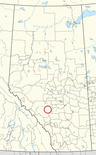
Sunchild 202 is an Indian reserve in Alberta. It is located 44 kilometres (27 mi) northwest of Rocky Mountain House. It is at an elevation of 974 metres (3,196 ft). The population in 2006 was 482. The median age of the population 19.6.

Beaver Ranch 163A is an Indian reserve of the Tallcree First Nation in Alberta, located within Mackenzie County. It is 82 kilometres east of High Level.
O'Chiese Cemetery 203A is an Indian reserve of the O'Chiese First Nation in Alberta, located within Clearwater County. It is 13 kilometres southwest of Rocky Mountain House.
