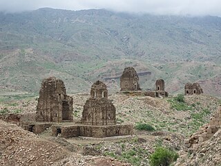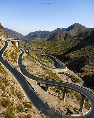
The Sulaiman Mountains, also known as Kōh-e Sulaymān or Da Kasē Ghrūna, are a north–south extension of the southern Hindu Kush mountain system in Pakistan and Afghanistan. They are also known as Aparanchal Range, or Western Mountains, as they mark the westernmost boundary of the Indian Subcontinent. They rise to form the eastern edge of the Iranian plateau. They are located in the Kandahar, Zabul and Paktia provinces of Afghanistan, and in Pakistan they extend over the northern part of Balochistan and Waziristan as well as Kurram of Khyber Pakhtunkhwa. In southwestern Punjab, the mountains extend into the two districts of Dera Ghazi Khan and Rajanpur, which are located west of the Indus River on the boundary with Balochistan. Bordering the mountains to the east are the plains of the Indus River valley, and to the north are the arid highlands of the Central Hindu Kush whose heights extend up to 3,383 metres (11,099 ft). The total area on which this range spans around 6,475 sq. km. Together with the Kirthar Mountains on the border between Balochistan and Sindh, the Sulaiman Mountains form what is known as the Sulaiman-Kirthar geologic province.

West Punjab was a province in the Dominion of Pakistan from 1947 to 1955. It was established from the western-half of British Punjab, following the independence of Pakistan. The province covered an area of 159,344 km sq, including much of the current Punjab province and the Islamabad Capital Territory, but excluding the former Princely state of Bahawalpur. Lahore, being the largest city and the cultural centre, served as the capital of the province. The province was composed of four divisions and was bordered by the state of Bahawalpur to the south-east, the province of Baluchistan to the south-west and Sind to the south, North-West Frontier Province to the north-west, and Azad Jammu and Kashmir to the north. It shared International border with Indian state of East Punjab to the east and Indian-administered Jammu & Kashmir to the north-east. It was dissolved and merged into West Pakistan upon creation of One Unit Scheme, in 1955.

Dera Ismail Khan, abbreviated as D.I. Khan, is a city and capital of Dera Ismail Khan District, located in Khyber Pakhtunkhwa, Pakistan. It is the 10th largest city of Pakistan and third or fourth largest in the province of Khyber Pakhtunkhwa by population. Dera Ismail Khan is situated on the west bank of the Indus River, at its junction with the Gomal River.

Dera Ismail Khan District, often abbreviated as D.I. Khan is a district in the Dera Ismail Khan division of the Khyber Pakhtunkhwa province of Pakistan. The capital of the district is the town of Dera Ismail Khan. The district has an area of 9,334 km2 (3,604 sq mi) and a population of 1,822,916 as of the 2023 Census. After the Second Anglo-Sikh war in 1849 the district was annexed by the British as part of the Punjab and remained so until 1901 when NWFP Khyber Pakhtunkhwa was created.

Derajat is a historical and cultural region in central Pakistan, bounded by the Indus River to the east and the Sulaiman Mountains to the west. It is located in the area where the provinces of Punjab, Khyber Pakhtunkhwa, and Balochistan meet.

Dera Ghazi Khan, abbreviated as D.G. Khan, is a city in the southwestern part of Punjab, Pakistan. It is the 23th most populous city of Pakistan as of 2023. Lying west of the Indus River, it is the headquarters of Dera Ghazi Khan District and Dera Ghazi Khan Division. Punjab Pakistan

Dera Ghazi Khan is a district in Punjab, Pakistan. Its administrative capital is Dera Ghazi Khan.

Rajanpur is a district of Dera Ghazi Khan Division in the Pakistani province of Punjab, with its administrative headquarters the city of Rajanpur. District of Rajanpur was formerly part of Dera Ghazi Khan District and was created on 1 July 1982. According to the 2023 Pakistani census, the district had a population of 2,323,980.

Layyah, previously spelled as Leiah, is a city in Pakistan. The city is headquarter of Layyah District and Layyah Tehsil. It is the 75th most populous city of Pakistan.

Fort Munro, formerly known as Tuman Leghari, is a hill station which is located at a height of 6,470 feet (1,970 m) above sea level in Dera Ghazi Khan District of Punjab, Pakistan. Fort Munro or formerly 'Tuman leghari' is the head quarter of the Leghari tribe. Fort Munro is part of Sulaiman mountain range. It was developed by British government in late 19th century.

Dera Ghazi Khan Division is an administrative division of the Punjab Province, Pakistan. The division was established in 1982.
Dera Ghazi Khan, is an administrative subdivision (tehsil) of Dera Ghazi Khan District in the Punjab province of Pakistan. The capital of the tehsil is Dera Ghazi Khan.
Kot Chutta is a tehsil administrative subdivision of Dera Ghazi Khan District in the Punjab Province of Pakistan. Kot Chutta is situated off the Indus Highway.
'Mangrotha is a town of two parts of union councile i.e mangrotha east and mangrotha west which is located near koh-e Sulaman which is richest mountains area of mineral in pakistan.and union council of Dera Ghazi Khan District in the Punjab province of Pakistan
Shadan Lund is a small city in between Dera Ghazi Khan and Taunsa Shareef. Lund is a Baloch tribe of Pakistan. Lund is Balochi word meaning "warrior". The Chief families are Saraiki speaking and are of Baloch descent. This town is situated near the Taunsa Barrage 12 km from the Koh-e-Sulaiman mountain range. The village of Basti Azeem is located 7 km south of this city and the village of Ghuman is located 2 km south of the city.
The Pitafis (پتافي) are an ethnic Baloch tribe found in Pakistan, present especially in the Dera Ghazi Khan district.

Saraikistan, also proposed as Bahawalpur-South Punjab or Bahawalpur Janoobi Punjab, are the names for the proposals to create a new province in Pakistan, out of the southern regions of Punjab. The region comprises the Bahawalpur, Multan and Dera Ghazi Khan divisions. The proposed province would form about 52 percent of the total area and almost 40 percent of the population of the current Punjab province. It has also been proposed to create instead two provinces in South Punjab.
Damaan Valley is a valley of Dera Ismail Khan District in Khyber-Pakhtunkhwa province of Pakistan. It is situated 55 km from Dera Ismail Khan. Sherani mountain range on its west side and Sulaiman Range in the south-west. Pezu mountains Sheikh Budin range mark its boundary on the north east side. River Indus bounds Damaan from the east and Dera Ghazi Khan District Punjab lies on its south side.

The National Highway 70, or the N-70, is one of the National Highways of Pakistan. It runs from the city of Multan in Punjab to the town of Qilla Saifullah via Dera Ghazi Khan, and Loralai in Balochistan province. Its total length is 440 kilometres (270 mi) divided into 254 kilometres (158 mi) in Balochistan and the remaining 186 km (116 mi) in the Punjab. It is maintained and operated by Pakistan's National Highway Authority.


