Piazza dell'Indipendenza (Rome)

Last updated
Piazza dell'Indipendenza
Roma--rom-atac-sl-1096584.jpg
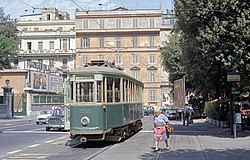
View of the square (1970)
Piazza dell'Indipendenza (Rome)
Click on the map for a fullscreen view
Location Rome, Italy
Postal code00185
Coordinates 41°54′16″N12°30′09″E / 41.904377°N 12.502469°E / 41.904377; 12.502469
Major
junctions
Via Solferino &
Via San Martino della Battaglia
Construction
Construction start1872

Piazza dell'Indipendenza (Independence Square) in Rome is a square in Municipio V (the 5th municipality) of the Castro Pretorio district of the Italian capital city. It is situated between Via Solferino and Via San Martino della Battaglia.

Contents

History

After the annexation of Rome by the Kingdom of Italy, in 1871, work began on the construction of a new district at the Castro Pretorio. The first settlement was built for the nobility and the upper middle class that had migrated to Rome to serve in a political office or the Royal Court, while Esquilino, also under construction, was intended for the clerical and petty bourgeois classes. The new quarter was built around a square that would function as the center of the new area. In 1872, it was decided to name it Independence Square, honoring the Italian War of Independence. [1] The new square rose roughly where in Ancient Rome stood Campus Scelleratus, the place where the Vestali (the Vestal Virgins) who violated their virginity vows were buried alive. [2]

By 1872, the square was already called "the new quarter" in travel books. [3]

Notable sights

The Palazzo dei Marescialli (the Marshalls Palace), built in 1937 by Costantino Costantini, houses the Consiglio Superiore della Magistratura (the High Council of the Judiciary). In 1979, a bomb was placed in a car near the building by members of the far-right terrorist organization Movimento Rivoluzionario Popolare (Revolutionary Popular Movement) but it malfunctioned and failed to explode. [4]

Related Research Articles

<span class="mw-page-title-main">Tivoli, Lazio</span> Comune in Lazio, Italy

Tivoli is a town and comune in Lazio, central Italy, 30 kilometres north-east of Rome, at the falls of the Aniene river where it issues from the Sabine hills. The city offers a wide view over the Roman Campagna.

<span class="mw-page-title-main">Capitoline Hill</span> One of the seven hills of Rome, Italy

<span class="mw-page-title-main">Victor Emmanuel II Monument</span> Building in Rome, Italy

The Victor Emmanuel II National Monument, also known as Vittoriano or Altare della Patria, is a large national monument built between 1885 and 1935 to honour Victor Emmanuel II, the first king of a unified Italy, in Rome, Italy. It occupies a site between the Piazza Venezia and the Capitoline Hill. The monument was realized by Giuseppe Sacconi.

<span class="mw-page-title-main">Trevi (rione of Rome)</span> Rione of Rome in Lazio, Italy

Trevi is the 2nd rione of Rome, identified by the initials R. II, located in Municipio I. The origin of its name is not clear, but the most accepted theory is that it comes from the Latin trivium, because there were three streets all leading to the current Piazza dei Crociferi, a square next to the modern Trevi square. Its coat of arms is made of three swords on a red background.

<span class="mw-page-title-main">Borgo (rione of Rome)</span> Rione of Rome in Lazio, Italy

Borgo is the 14th rione of Rome, Italy. It is identified by the initials R. XIV and is included within Municipio I.

<span class="mw-page-title-main">Esquilino (rione of Rome)</span> Rione of Rome in Lazio, Italy

Esquilino is the 15th rione of Rome, identified by the initials R. XV, and is Located within the Municipio I. It is named after the Esquiline Hill, one of the Seven Hills of Rome.

<span class="mw-page-title-main">Sallustiano</span> Rione of Rome in Lazio, Italy

Sallustiano is the 17th rione of Rome, identified by the initials R. XVII. It is located within the Municipio I and the name refers to the ancient Gardens of Sallust, which were located here.

<span class="mw-page-title-main">Castro Pretorio</span> Rione of Rome in Lazio, Italy

Castro Pretorio is the 18th rione of Rome (Italy), identified by the initials R. XVIII, and it is located within the Municipio I. The rione takes its name by the ruins of the Castrum Praetorium, the barracks of the Praetorian Guard, included in the Aurelian Walls.

<span class="mw-page-title-main">Palazzo Barberini</span> Palace in Rome now an art museum

The Palazzo Barberini is a 17th-century palace in Rome, facing the Piazza Barberini in Rione Trevi. Today, it houses the Galleria Nazionale d'Arte Antica, the main national collection of older paintings in Rome.

<span class="mw-page-title-main">Piazza Venezia</span> Square in Rome, Italy

Piazza Venezia is a central hub of Rome, Italy, in which several thoroughfares intersect, including the Via dei Fori Imperiali and the Via del Corso. It takes its name from the Palazzo Venezia, built by the Venetian Cardinal, Pietro Barbo alongside the church of Saint Mark, the patron saint of Venice. The Palazzo Venezia served as the embassy of the Republic of Venice in Rome.

<span class="mw-page-title-main">Via dei Fori Imperiali</span> Thoroughfare in Rome, Italy

The Via dei Fori Imperiali is a road in the centre of the city of Rome, Italy, that runs in a straight line from the Piazza Venezia to the Colosseum. Its course takes it over parts of the Forum of Trajan, Forum of Augustus and Forum of Nerva, parts of which can be seen on both sides of the road. Since the 1990s, there has been a great deal of archeological excavation on both sides of the road, as significant Imperial Roman relics remain to be found underneath it.

<span class="mw-page-title-main">Porta Salaria</span> Former gate in the Aurelian Walls of Rome

Porta Salaria was a gate in the Aurelian Walls of Rome, Italy. Constructed between 271 AD and 275 AD, it was demolished in 1921.

<span class="mw-page-title-main">Castro Pretorio (Rome Metro)</span> Rome metro station

Castro Pretorio is a station on Line B of the Rome Metro. It was opened on 8 December 1990 and is located on Viale Castro Pretorio, at its junction with Via San Martino della Battaglia, in the Castro Pretorio rione. Its exit overlooks the Castra Praetoria, now the site of the Biblioteca Nazionale Centrale.

<span class="mw-page-title-main">Municipio I</span> Municipio of Rome in Lazio, Italy

Municipio I is an administrative subdivision of the municipality of Rome, encompassing the centre of the city.

<span class="mw-page-title-main">Porta Viminale</span>

The Porta Viminale was a gateway in the Servian Wall of ancient Rome, at the centre of the most exposed stretch of the wall between the Porta Collina and the Porta Esquilina. These three gates and the Porta Querquetulana were the oldest gates in the wall.

The following is a timeline of the history of the city of Treviso in the Veneto region of Italy.

<span class="mw-page-title-main">Borgo Nuovo (Rome)</span> Former road in Rome

Borgo Nuovo, originally known as via Alessandrina, also named via Recta or via Pontificum, was a road in the city of Rome, Italy, important for historical and architectural reasons. Built by Pope Alexander VI Borgia for the holy year of 1500, the road became one of the main centers of the high Renaissance in Rome. Borgo Nuovo was demolished together with the surrounding quarter in 1936–37 due to the construction of Via della Conciliazione.

<span class="mw-page-title-main">Piazza Scossacavalli</span> Former square in Rome

Piazza Scossacavalli, also named Piazza di San Clemente, Piazza di Trento, Piazza d'Aragona, Piazza Salviati, was a square in Rome, Italy, important for historical and architectonic reasons. The square was demolished together with the surrounding quarter in 1937 due to the construction of Via della Conciliazione.

<span class="mw-page-title-main">Nomentano</span> Quartiere of Rome in Lazio, Italy

Nomentano is the 5th quartiere of Rome (Italy), identified by the initials Q. V. The name derives from the ancient road Via Nomentana. It belongs to the Municipio II.

References

  1. "Piazza dell'Indipendenza" (in Italian). Rerum Romanarum. 2016. Retrieved 14 October 2020.
  2. Ball Platner, Samuel; Ashby, Thomas (1929) [1909]. A Topographical Dictionary of Ancient Rome (3rd ed.). Oxford University Press.
  3. "Latest Corrections and Additions". A Handbook of Rome and its Environs (12th ed.). London, England: John Murray. 1875 [1867]. Retrieved 15 October 2020.
  4. Casillo, Giuseppe (2012). A destra della destra: Terza Posizione [To the right of the right: Third Position] (Thesis) (in Italian). Universitá degli Studi del Molise.

Further reading