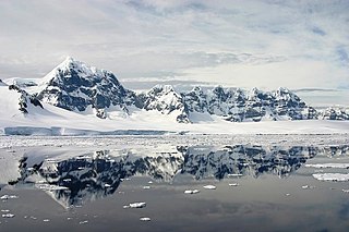
Wiencke Island is an island 26 km (16 mi) long and from 3 to 8 km wide, about 67 km2 (26 sq mi) in area, the southernmost of the major islands of the Palmer Archipelago, lying between Anvers Island to its north across the Neumayer Channel and the west coast of the Antarctic Peninsula to its east across the Gerlache Strait.

Andrée Land is a peninsula in King Christian X Land, East Greenland that is bounded by Kejser Franz Joseph Fjord, Isfjord and Geologfjord.
Jøkel Bay is a large bay in North Eastern Greenland. The area of the bay is uninhabited. Administratively Jøkel Bay and its surroundings belong to the Northeast Greenland National Park.

Frederick E. Hyde Fjord is a fjord in Peary Land, far northern Greenland.

The Watkins Range is Greenland's highest mountain range. It is located in King Christian IX Land, Sermersooq municipality.
Payer Peak, is a mountain in King Christian X Land, Northeast Greenland. Administratively it is part of the Northeast Greenland National Park zone.
Petermann Peak,, also known as Petermann Fjeld, Petermanns Topp and Petermann Point is a mountain in King Christian X Land, Northeast Greenland. Administratively it is part of the Northeast Greenland National Park zone.

Schweizerland, also known as Schweizerland Alps, is a mountain range in King Christian IX Land, eastern Greenland. Administratively this range is part of the Sermersooq Municipality. Its highest point is one of the highest peaks in Greenland.

Queen Louise Land is a vast mountainous region located west of Dove Bay, King Frederik VIII Land, northeastern Greenland. Administratively it is part of the Northeast Greenland National Park zone.

Revaltoppe is one of the highest mountains in Queen Louise Land, NE Greenland. The peak is located in the King Frederick VIII Land area of northeastern Greenland. Administratively it is part of the Northeast Greenland National Park zone.

The Gronau Nunataks is a mountain range in King Christian IX Land, eastern Greenland. Administratively this range is part of the Sermersooq Municipality.

The Lindbergh Range or Lindbergh Nunataks is a mountain range in King Christian IX Land, eastern Greenland. Administratively the range is part of the Sermersooq Municipality.
Nordkrone is a mountainous area in Peary Land, Northern Greenland. Administratively it is part of the Northeast Greenland National Park.

The Roosevelt Range or Roosevelt Mountains is a mountain range in Northern Greenland. Administratively this range is part of the Northeast Greenland National Park. Its highest peak is the highest point in Peary Land.
Louise Boyd Land is an area in King Christian X Land, Eastern Greenland. Administratively it lies in the Northeast Greenland National Park zone. The area is remote and uninhabited.

Geologfjord is a fjord in King Christian X Land, East Greenland. Administratively it belongs to the Northeast Greenland National Park.

Nunatak Glacier, also known as Nunatak Glacier, is a glacier in King Christian X Land, Northeast Greenland. Administratively it lies in the Northeast Greenland National Park zone.
Duke of Orléans Land is a land area —possibly a peninsula— in King Frederick VIII Land, northeastern Greenland. Administratively it belongs to the NE Greenland National Park area.

Alabama Nunatak is a nunatak in the King Frederik VIII Land area of northeastern Greenland. Administratively it is part of the Northeast Greenland National Park zone.

