Related Research Articles

Chile, officially the Republic of Chile, is a country in western South America. It is the southernmost country in the world and the closest to Antarctica, stretching along a narrow strip of land between the Andes Mountains and the Pacific Ocean. Chile had a population of 17.5 million as of the latest census in 2017 and has a territorial area of 756,102 square kilometers (291,933 sq mi), sharing borders with Peru to the north, Bolivia to the northeast, Argentina to the east, and the Drake Passage to the south. The country also controls several Pacific islands, including Juan Fernández, Isla Salas y Gómez, Desventuradas, and Easter Island, and claims about 1,250,000 square kilometers (480,000 sq mi) of Antarctica as the Chilean Antarctic Territory. The capital and largest city of Chile is Santiago, and the national language is Spanish.

A municipality is usually a single administrative division having corporate status and powers of self-government or jurisdiction as granted by national and regional laws to which it is subordinate.

Santiago, also known as Santiago de Chile, is the capital and largest city of Chile and one of the largest cities in the Americas. It is located in the country's central valley and is the center of the Santiago Metropolitan Region, which has a population of seven million, representing 40% of Chile's total population. Most of the city is situated between 500–650 m (1,640–2,133 ft) above sea level.

Valparaíso is a major city, commune, seaport and naval base facility in Valparaíso Region, Chile.

The Antofagasta Region is one of Chile's sixteen first-order administrative divisions. Being the second-largest region of Chile in area, it comprises three provinces, Antofagasta, El Loa and Tocopilla. It is bordered to the north by Tarapacá, by Atacama to the south, and to the east by Bolivia and Argentina. The region's capital is the port city of Antofagasta; another one of its important cities is Calama. The region's main economic activity is copper mining in its giant inland porphyry copper systems.

The Coquimbo Region is one of Chile's 16 administrative regions. It is located approximately 400 kilometres (250 mi) north of the national capital, Santiago. The region is bordered by the Atacama Region to the north, the Valparaíso Region to the south, Argentina to the east, and the Pacific Ocean to the west.

Hatch is a village in Doña Ana County, New Mexico, United States. The population was 1,648 at the 2010 census. The town is experiencing moderate growth, along with its outliers of Salem, Arrey, Derry, and Rincon. Hatch is widely known as the "best chile place in the World," for growing a wide variety of peppers, especially the New Mexican cuisine staple, and one of New Mexico's state vegetables, the New Mexico chile.
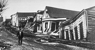
The 1960 Valdivia earthquake and tsunami or the Great Chilean earthquake on 22 May 1960 was the most powerful earthquake ever recorded. Most studies have placed it at 9.4–9.6 on the moment magnitude scale, while some studies have placed the magnitude lower than 9.4. It occurred in the afternoon, and lasted 10 minutes. The resulting tsunamis affected southern Chile, Hawaii, Japan, the Philippines, eastern New Zealand, southeast Australia, and the Aleutian Islands.
The Chile national football team, nicknamed La Roja, represents Chile in men's international football competitions and is controlled by the Federación de Fútbol de Chile which was established in 1895. Chile has appeared in nine World Cup tournaments and were hosts of the 1962 FIFA World Cup where they finished in third place, the highest position the country has ever achieved in the World Cup.

The Maule Region is one of Chile's 16 first order administrative divisions. Its capital is Talca. The region derives its name from the Maule River which, running westward from the Andes, bisects the region and spans a basin of about 20,600 km2. The Maule river is of considerable historic interest because, among other reasons, it marked the southern limits of the Inca Empire.

Castro is a city and commune on Chiloé Island in Chile. Castro is the capital of the Chiloé Province in the Los Lagos Region. The city is located on Estero de Castro on the eastern coast of central Chiloé Island. This position provides Castro with a good access to the eastern islands of Chiloé Archipelago as well as to the open ocean through Cucao and Huillinco to the west.

A commune is the smallest administrative subdivision in Chile. It may contain cities, towns, villages, hamlets as well as rural areas. In highly populated areas, such as Santiago, Valparaíso and Concepción, a conurbation may be broken into several communes. In sparsely populated areas, conversely, a commune may cover a substantial rural area together with several settled areas which could range from hamlets to towns or cities.
Kunza is a mostly extinct language isolate spoken in the Atacama Desert of northern Chile and southern Peru by the Atacama people, who have since shifted to Spanish. The last speaker was documented in 1949; however, it has since been learned that the language is still spoken in the desert.

Chacalluta International Airport is an airport serving the city of Arica, capital of the Arica Province in the northern Arica y Parinacota Region of Chile. It is 18.5 kilometres (11.5 mi) northwest of the city and 1 kilometre (0.62 mi) south of the border with Peru, adjacent to the village of Villa Frontera.
Balmaceda Airport is an airport next to the village of Balmaceda, serving the Aysén Region of Chile. The airport is 4 kilometres (2.5 mi) west of the Argentina border, it is located 55 km south-east of Coyhaique, the regional capital.

Augusto José Ramón Pinochet Ugarte was a Chilean military officer who was the dictator of Chile from 1973 to 1990. From 1973 to 1981, he was the leader of the military junta, which in 1974 declared him President of the Republic and thus the dictator of Chile; in 1980, a referendum approved a new constitution confirming him in the office, after which he served as de jure president from 1981 to 1990. His time in office remains the longest of any Chilean ruler.

The Teniente Rodolfo Marsh Martin Airport is on King George Island, part of Chile's Antártica commune in Antarctica, and is the northernmost airport in the continent. The airport serves the nearby village of Villa Las Estrellas and the Base Presidente Eduardo Frei Montalva.
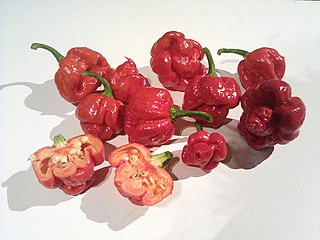
The Trinidad Moruga scorpion is a chili pepper native to the village of Moruga, Trinidad and Tobago. In 2012, New Mexico State University's Chile Pepper Institute identified the Trinidad Moruga scorpion as the hottest chili pepper at that time, with heat of 1.2 million Scoville heat units (SHUs).
Chiling Sumda is a village in the Leh district of Ladakh, India. It is located Nimmu–Padum–Darcha road (NPDR) or Zanskar Highway in the Likir tehsil, on the bank of the Zanskar River in Zanskar region. It serves as a base camp for the Chadar Trek in the winters and is used to raft the Zanskar river in the summers.
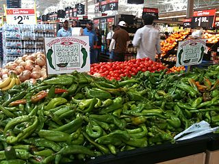
New Mexico chile or New Mexican chile is a cultivar group of the chile pepper from the US state of New Mexico, first grown by Pueblo and Hispano communities throughout Santa Fe de Nuevo México. These landrace chile plants were used to develop the modern New Mexico chile peppers by horticulturist Fabián García and his students, including Roy Nakayama, at what is now New Mexico State University in 1894.
References
Railway stations in Southern Chile | ||
|---|---|---|
| Main line | ||
| Ramal Valdivia–Antilhue | ||
| Ramal Los Lagos–Riñihue | ||
| | This Los Ríos Region location article is a stub. You can help Wikipedia by expanding it. |