Pico Piedras Blancas

Last updated
Pico Piedras Blancas
PiedrasBlancasMucumamo.JPG
Pico Piedras Blancas (Right) and Pico Mucumamó (left) seen from Alto de Mifafí
Highest point
Elevation 4,737 m (15,541 ft)
Coordinates 8°51′N71°57′W / 8.850°N 71.950°W / 8.850; -71.950
Geography
Location Mérida, Mérida, Venezuela
Parent range Sierra de la Culata, Andes
Climbing
First ascent Unknown, however [1]
Easiest route Walk, easy climb PD

The Pico Piedras Blancas (also known as Misamán), at 4,737 metres (15,541 ft), is the highest mountain of the Sierra de la Culata range in the Mérida State, and the fifth-highest mountain in Venezuela. Its name, meaning "White Stones", is of uncertain origin, since the massif is predominantly grey in color. [2] Pico Piedras Blancas lacks glaciers; however, seasonal snowfalls may briefly cover its flanks. From its summit and under clear conditions, Lake Maracaibo can be seen. One of the accesses to reach the base of the mountain, is through the Mifafí Condor Reserve, which hosts some specimens of this andean bird.

Sierra de la Culata mountain

The Sierra de La Culata is a mountain range in the largest massif in Venezuela, the Cordillera de Mérida, which in turn is part of the northern extent of the Cordillera de los Andes. The Sierra la Culata includes some of the highest peaks in Venezuela, such as Pico Piedras Blancas, Pico Pan de Azúcar, and Collado del Cóndor.

Venezuela Republic in northern South America

Venezuela, officially the Bolivarian Republic of Venezuela, is a country on the northern coast of South America, consisting of a continental landmass and a large number of small islands and islets in the Caribbean Sea. The capital and largest urban agglomeration is the city of Caracas. It has a territorial extension of 916,445 km2. The continental territory is bordered on the north by the Caribbean Sea and the Atlantic Ocean, on the west by Colombia, Brazil on the south, Trinidad and Tobago to the north-east and on the east by Guyana. With this last country, the Venezuelan government maintains a claim for Guayana Esequiba over an area of 159,542 km2. For its maritime areas, it exercises sovereignty over 71,295 km2 of territorial waters, 22,224 km2 in its contiguous zone, 471,507 km2 of the Caribbean Sea and the Atlantic Ocean under the concept of exclusive economic zone, and 99,889 km2 of continental shelf. This marine area borders those of 13 states. The country has extremely high biodiversity and is ranked seventh in the world's list of nations with the most number of species. There are habitats ranging from the Andes Mountains in the west to the Amazon basin rain-forest in the south via extensive llanos plains, the Caribbean coast and the Orinoco River Delta in the east.

Lake Maracaibo large lake in Venezuela with an outflow to the Caribbean Sea

Lake Maracaibo is a large brackish tidal bay in Venezuela and an "inlet of the Caribbean Sea." It is sometimes considered a lake rather than a bay or lagoon. It is connected to the Gulf of Venezuela by Tablazo Strait which is 5.5 kilometres (3.4 mi) wide at the northern end. It is fed by numerous rivers, the largest being the Catatumbo. At 13,210 square kilometres (5,100 sq mi) it was once the largest lake in South America; the geological record shows that it was a true lake in the past, and as such is one of the oldest lakes on Earth at 20–36 million years old.

Contents

Location

Pico Piedras Blancas is located 35 km (22 mi) to the northeast of Mérida, the state capital. Pico Piedras Blancas is very close to Pico Mucumamó, Pico Los Nevados and Pico El Buitre; all of them surround a high altitude valley in the heart of the Sierra de la Culata at approximately 4,200 metres (13,800 ft) above sea level, known on topographic maps as Hoyo Negro ("Black Hole").

Mérida, Mérida Place in Mérida, Venezuela

Mérida, officially known as Santiago de los Caballeros de Mérida, is the capital of the municipality of Libertador and the state of Mérida, and is one of the principal cities of the Venezuelan Andes. It was founded in 1558 by Captain Juan Rodríguez Suárez, forming part of Nueva Granada, but later became part of the Captaincy General of Venezuela and played an active role in the War of Independence.

Elevation

A former measure of 4,762 metres, given by Jahn in 1910, was corrected to 4,737 metres in 1951. The latter measure was confirmed by a 2002 GPS survey.

Climbing

Though being the highest mountain of the Sierra de la Culata, it is not as frequently climbed as Pico Pan de Azucar in the same range of La Culata or the highest peaks of the Sierra Nevada de Mérida range.

Sierra Nevada de Mérida glacier

The Sierra Nevada de Mérida is the highest mountain range in the largest massif in Venezuela, the Cordillera de Mérida, which in turn is part of the northern extent of the Cordillera de los Andes. The Sierra Nevada de Mérida includes the highest peaks in Venezuela, Pico Bolívar, which has an elevation of 4,981 metres (16,342 ft), Pico Humboldt, Pico Bonpland and others.

The dry season is a yearly period of low rainfall, especially in the tropics. The weather in the tropics is dominated by the tropical rain belt, which moves from the northern to the southern tropics and back over the course of the year. The tropical rain belt lies in the southern hemisphere roughly from October to March; during that time the northern tropics have a dry season with sparser precipitation, and days are typically sunny throughout. From April to September, the rain belt lies in the northern hemisphere, and the southern tropics have their dry season. Under the Köppen climate classification, for tropical climates, a dry season month is defined as a month when average precipitation is below 60 millimetres (2.4 in).

Related Research Articles

Mérida (state) State of Venezuela

The Bolivarian State of Mérida, commonly known simply as Mérida State is one of the 23 states of Venezuela. The state capital is Mérida, in the Libertador Municipality.

Pico da Neblina Biggest mountain in Brazil

Pico da Neblina is the highest peak in Brazil, 2,995.3 metres (9,827 ft) above sea level, in the Serra da Neblina, part of the Serra do Imeri, a section of the Guiana Highlands on the Brazil–Venezuela border. As determined by a border survey expedition in 1962, its summit lies just within Brazilian territory, at a horizontal distance of only 687 m (2,254 ft) from the Venezuelan border at Pico 31 de Março.

Cantabrian Mountains

The Cantabrian Mountains or Cantabrian Range are one of the main systems of mountain ranges in Spain. They stretch for over 300 km (180 miles) across northern Spain, from the western limit of the Pyrenees to the Galician Massif in Galicia, along the coast of the Cantabrian Sea. Their easternmost end meets the Sistema Ibérico.

Pico Bolívar mountain

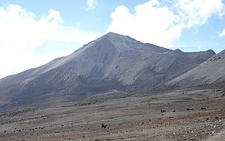
Pico Bolívar is the highest mountain in Venezuela, at 4,978 metres. Located in Mérida State, its top is permanently covered with névé snow and three small glaciers. It can be reached only by walking; the Mérida cable car, was the highest and longest cable car in the world when it was built, and only reaches Pico Espejo. From there it is possible to climb to Pico Bolívar. The peak is named after the Venezuelan independence hero Simón Bolívar.

Cordillera de Mérida mountain range

The Cordillera de Mérida is a series of mountain ranges, or massif, in northwestern Venezuela. The Cordillera de Mérida is a northeastern extension of the Andes Mountains and the most important branch of the Venezuelan Andes. The ranges run southwest-northeast between the Venezuelan-Colombian border and the Venezuelan Coastal Ranges. The Táchira depression separates the Cordillera de Mérida from the Cordillera Oriental, which forms the Colombia-Venezuela border.

Cordillera Oriental (Colombia) mountain range in Colombia

The Cordillera Oriental is the widest of the three branches of the Colombian Andes. The range extends from south to north dividing from the Colombian Massif in Huila Department to Norte de Santander Department where it splits into the Serranía del Perijá and the Cordillera de Mérida in Venezuelan Andes. The highest peak is Ritacuba Blanco at 5,410 m (17,750 ft) in the Sierra Nevada del Cocuy.

Pico Pan de Azúcar mountain in Venezuela

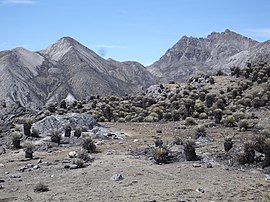
The Pico Pan de Azúcar, at 4680 meters above sea level, is the ninth highest mountain of Venezuela, and the third highest of the Sierra de la Culata range in the Mérida State. Its name, which translates as "Bread of Sugar", is due to the sandy slopes of the mountain, which resembles "Pan dulce", a kind of bread sprinkled with sugar eaten in the country. The summit offers a scenic view, including Lake Maracaibo, Sierra Nevada de Mérida and the surrounding mountains of the Sierra de la Culata.

The Climate of Venezuela is characterized for being tropical and isothermal as a result of its geographical location near the Equator, but because of the topography and the dominant wind direction, several climatic types occur which can be the same as found in temperate latitudes, and even polar regions. Latitude exerts little influence on the Venezuelan climate, but the altitude changes it dramatically, particularly the temperature, reaching values very different according to the presence of different thermal floors.

Pico El Águila mountain in Venezuela

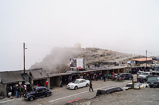
Pico El Águila or Collado del Cóndor is the milestone that stands at the highest elevation on the Venezuelan Transandean Highway in the Cordillera de Mérida of Venezuela. Nearby stands a monument, sculpted by a Colombian artist, Marcos León Mariño, depicting a condor, commemorating an event in the campaign of the Liberator, Simón Bolivar. It is located in Mérida (state) and has an altitude of 4,118 meters.

<i>Ardaris</i> genus of insects

Ardaris is a Neotropical genus of firetips in the family Hesperiidae. It includes two endemic species that are restricted to mountain forests and páramos in the Cordillera de Mérida, Venezuela.

Venezuelan Andes

The Venezuelan Andes also simply known as the Andes in Venezuela, are a mountain system that form the northernmost extension of the Andes. They are fully identified, both by their geological origin as by the components of the relief, the constituent rocks and the geological structure.

Sierra Nevada National Park (Venezuela) Venezuelan National Park

The Sierra Nevada National Park (PNSN) is an important National Park of Venezuela located between Mérida and Barinas states in the west of the country. It was created on May 2, 1952, by decree of President Germán Suárez Flamerich, in order to protect the Sierra Nevada de Mérida in the Andes.

Transandean Highway highest highway in Venezuela

The Trans-Andean Highway, was inaugurated on July 24, 1925. It is 1,539 km long. It runs through the Venezuelan states of Mérida, Trujillo and Táchira, from the proximities of Agua Viva up until San Cristóbal. Its highest point is located on Collado del Cóndor, at 4,118 meters, making it the highest highway in Venezuela.

Tourism in Venezuela

Tourism in Venezuela has been developed considerably for decades, particularly because of its geographical position, the variety of landscapes, the richness of plant and wildlife, the artistic expressions and the privileged tropical climate of the country, which affords each region throughout the year. Since 2013 the country is having a very severe economical crisis affecting the tourism all over the country.

Natural regions of Venezuela

Because of its natural structure, Venezuela can be divided into eight very distinct natural regions. In the evaluation of a natural region, the human element is not present. The natural region groups of Venezuela formed as a consequence of the association of geo-physical elements such as: geological constitution, relief, climate, hydrography, vegetation, soils, among others.

Sierra La Culata National Park

The Sierra La Culata National Park Also Sierra de la Culata National Park is a national park of Venezuela that is located in the northeastern branch of the Venezuelan Andes, in the states Mérida and Trujillo. It was decreed a national park on December 7, 1989. It has a high mountain climate, with temperatures ranging between −2 and 24 °C, and its surface area is 200,400 hectares (774 sq mi).

General Juan Pablo Peñaloza National Park

The General Juan Pablo Peñaloza National Park Also Páramos Batallón y La Negra National Park Is a national park of Venezuela that is formed by several páramos: Among them Batallón and La Negra, which are an important source of water supply. It is located between the states Mérida and Táchira, northwest of the Táchira depression in the Páramos de El Batallón and La Negra in Venezuela.

Cordillera de Merida páramo

The Cordillera de Merida páramo (NT1004) is an ecoregion containing páramo vegetation above the treeline in the Andes mountain range of Venezuela. The isolated habitat has many endemic species. It is relatively stable and intact.

References

Notes

  1. It is known that guide Daniel Toro and his father climbed it toward 1964.
  2. Although there is some uncertainty regarding the name of the mountain, there is a local legend about the origin of the mountains and surrounding lagoons at Páramo de Piedras Blancas. It tells about the mourning into which the women of the local indigenous tribes fell after the conquistadors slaughtered their husbands. God, afflicted by "the suffering of His daughters", and wanting to alleviate their great sorrow, turned them into mountains, but still those "mountains" cried, giving origin with their "tears" to the local lagoons. If any tear became entrapped inside any frailejón, or trap of the terrain, it would turn into a "stone as white as milk, of which there are thousands on the summits of the Páramo de Piedras Blancas".