
The Maggia is a river in the Swiss canton of Ticino.

Travacò Siccomario is a comune (municipality) in the Province of Pavia in the Italian region Lombardy, located about 35 km south of Milan and about 4 km southeast of Pavia, near the confluence of the Po and Ticino rivers.

Pizzo Campo Tencia is a mountain in the Lepontine Alps, which lies in the canton of Ticino, Switzerland. Pizzo Campo Tencia is the highest peak located entirely inside the canton.

The Cristallina is a mountain of the Lepontine Alps, located in the Swiss canton of Ticino. It is situated between the valleys of Leventina, Val Bavona and Valle di Peccia (the latter two belonging to the Valle Maggia. On the west side of the mountain is located the Passo Cristallina with the Cristallina Hut.
The Cima dell'Uomo is a mountain of the Swiss Lepontine Alps, located north-west of Monte Carasso in the canton of Ticino. It lies east of the slightly higher Pizzo di Vogorno, near the southern end of the range separating the main valley of the Ticino from Valle Verzasca.

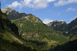
The Madom Gröss is a mountain in the Lepontine Alps of Switzerland. It is located between the Valle Verzasca and Valle Leventina, near Sonogno, Ticino.
Monte Zucchero is a mountain in the Lepontine Alps of Switzerland. It is located between Bignasco and Sonogno in the canton of Ticino. Reaching a height of 2,735 metres above sea level, Monte Zucchero is the highest summit on the range south of the Passo di Redorta, that separates the Valle Maggia from the Valle Verzasca.

The Torent Alto is a mountain of the Swiss Lepontine Alps, located on the border between the cantons of Ticino and Graubünden. It is the highest mountain lying on the chain between Pass Giümella, east of Biasca and Bellinzona.
Pizzo di Porcaresc is a mountain of the Lepontine Alps, located on the border between Switzerland and Italy. Its summit is the tripoint between the Valle dell'Isorno, the Valle di Campo and the Valle di Vergeletto.
Pizzo Castello is a mountain of the Lepontine Alps, located in the canton of Ticino, Switzerland. It is situated in the upper Valle Maggia, between the Val Bavona (west) and Valle di Peccia (east).
The Rosso di Ribia is a mountain of the Lepontine Alps, located in the canton of Ticino, Switzerland. with a height of 2,547 metres above sea level, it is the culminating point on the range between the Valle di Campo and Valle di Vergeletto. The Rosso di Ribia lies five kilometres east of Pizzo di Porcarese, where the border with Italy runs.
The Corona di Redorta is a mountain of the Swiss Lepontine Alps, located between Lavizzara and Sonogno in the canton of Ticino. Culminating at a height of 2,804 metres above sea level, the Corona di Redorta is the second highest summit of the Valle Verzasca, after Pizzo Barone.
The Cima di Broglio is a mountain of the Swiss Lepontine Alps, located east of Cevio in the canton of Ticino. It lies south of Monte Zucchero, on the range between the Valle Maggia and the Valle Verzasca.
Pizzo delle Pecore is a mountain of the Swiss Lepontine Alps, located east of Cevio in the canton of Ticino. It lies just south of the slightly higher Cima di Broglio, on the range between the Valle Maggia and the Valle Verzasca.
The Poncione Piancascia is a mountain of the Swiss Lepontine Alps, overlooking Brione in the canton of Ticino. It lies between the Valle Maggia and the Valle Verzasca. The Poncione di Piancascia has an elevation of 2,360 metres and is the highest summit on the range south of Pizzo delle Pecore.
Pizzo di Cadrèigh is a mountain of the Swiss Lepontine Alps, located west of Olivone in the canton of Ticino. It lies south of the Scopi, between the Val di Campo and the Valle Santa Maria.
Cima di Pinadee is a mountain of the Swiss Lepontine Alps, located east of Olivone in the canton of Ticino. It lies between the Valle di Blenio and the Val di Carassino, north of the Passo di Piotta.

The Blenio Valley is a valley of the Lepontine Alps in the Swiss canton of Ticino. The valley contains the river Brenno. The upper valley, between Lai da Sontga Maria and Olivone, is named Valle Santa Maria.
The Corno di Gesero is a mountain of the Lepontine Alps, located on the border between the Swiss cantons of Ticino and Graubünden. It lies on the range west of the Cima di Cugn, between the Valle d'Arbedo and the Val Traversagna.

The border between the modern states of Switzerland and Italy extends for 744 kilometres (462 mi), from the French-Swiss-Italian tripoint at Mont Dolent in the west to the Austrian-Swiss-Italian tripoint near Piz Lad in the east. Much of the border runs across the High Alps, rising above 4,600 metres (15,100 ft) as it passes east of Dufourspitze, but it also descends to the lowest point in Switzerland as it passes Lago Maggiore at below 200 metres (660 ft).
