Related Research Articles

Cuyahoga County Airport, also known as Robert D. Shea Field, is a public use airport in northeastern Cuyahoga County, Ohio, United States. Owned and operated by Cuyahoga County since 1946, it also serves Lake County and Geauga County. The airport is located 10 nautical miles east of downtown Cleveland and sits on the border of three cities: Highland Heights, Richmond Heights and Willoughby Hills. It is included in the National Plan of Integrated Airport Systems for 2011–2015, which categorized it as a general aviation reliever airport for Cleveland Hopkins International Airport.
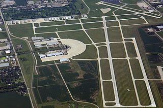
DuPage Airport is a general aviation airport located 29 miles (47 km) west of downtown Chicago in West Chicago, DuPage County, Illinois, United States. It is owned and operated by the DuPage Airport Authority, which is an independent government body established by law by the State of Illinois. It also serves as a relief airport for O'Hare International Airport and Chicago Midway International Airport, both in nearby Chicago.
Campbell Airport is a public-use airport located two miles (3 km) southwest of the central business district of Grayslake, a village in Lake County, Illinois, United States. It is privately owned by Kane Illinois Properties, Inc.
Poplar Grove Airport is a small general aviation airport located in Poplar Grove, Illinois, United States. The airport was founded in 1972 as Belvidere Airport and renamed in 1994. It is located 3 miles south of Poplar Grove, and 3 miles north of Belvidere. The airport is privately owned and open to the public.
Medina Municipal Airport is a public use airport in Medina County, Ohio, United States. It is owned by the City of Medina and is located four nautical miles (7.41 km) east of the city's central business district. According to the FAA's National Plan of Integrated Airport Systems for 2007-2011, it is categorized as a reliever airport.
Illinois Valley Regional Airport, also known as Walter A. Duncan Field, is a city-owned, public-use airport located 1 nautical mile northwest of the central business district of Peru, a city in LaSalle County, Illinois, United States. The airport was opened in November 1985. The airport hosts the TBM Avenger Reunion every year in May.
Paul C. Miller–Sparta Airport is a public airport located 3 mi (5 km) southeast of Sparta, Michigan. Established in 1941, the airport is currently owned and operated by the Village of Sparta and is self-supporting, requiring no public funding. It is included in the Federal Aviation Administration (FAA) National Plan of Integrated Airport Systems for 2017–2021, in which it is categorized as a regional general aviation facility.
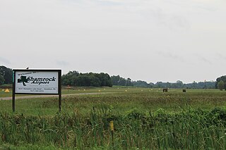
Brooklyn Airport, also known as Shamrock Field, is a privately-owned, public-use airport located in Brooklyn, Michigan, United States. It is at an elevation of 987 feet.
Jack Barstow Airport, also known as Jack Barstow Municipal Airport, is a city-owned, public-use airport located three nautical miles (6 km) northwest of the central business district of Midland, a city in Midland County, Michigan, United States. It is included in the Federal Aviation Administration (FAA) National Plan of Integrated Airport Systems for 2017–2021, in which it is categorized as a local general aviation facility.
Dalton Airport is a privately owned, public use airport located two nautical miles (4 km) east of the central business district of Flushing, in Genesee County, Michigan, United States. It is named after its founder, Edwin P. Dalton, who opened it in 1946 on the former site of the Marsa farm.
Taylorville Municipal Airport is a civil public-use airport in Taylorville, Illinois. It is owned by the City of Taylorville. The airport is located near both Springfield's Abraham Lincoln Capital Airport and Decatur Airport. It has been active since March 1947.
Pontiac Municipal Airport is a public use airport 3 miles north of Pontiac in Livingston County, Illinois. The airport is publicly owned by the City of Pontiac.
Cottonwood Airport is a public use airport located two-mile (3.2 km) northwest of Rockford, Illinois. The airport is privately owned. The airport is one of multiple airports in Rockford; the city's main airport, located six miles (9.7 km) south of Cottonwood, is the Chicago/Rockford International Airport.
Three Rivers Municipal Dr. Haines Airport is a public-use airport located two miles northeast of Three Rivers, Michigan. The aircraft is publicly owned by the city. The airport covers 305 acres.
Andrews University Airpark is a privately owned, public use airport located 2 miles west of Berrien Springs, Michigan. It is owned and managed by Andrews University, a Christian university that manages an aviation department.
Marine City Airport is a privately owned, public use airport located 4 miles west of Marine City in St. Clair County, Michigan.
Weltzien Skypark is a privately owned, public use airport located 3 miles west of Wadsworth, Ohio in Medina County. The airpark sits on 26 acres at an elevation of 1210 feet.
References
- 1 2 "FAA Information about Pinckneyville/Du Quoin Airport". airport-data.com. Retrieved 2022-07-12.
- ↑ "Pinckneyville-Du Quoin Airport gets Rebuild Illinois grant Part of $94 million going to 96 airports in state". DuQuoin Call. Retrieved 2022-07-12.
- 1 2 "Pinckneyville/Du Quoin Airport (KPJY) – AOPA". Aircraft Owners and Pilots Association (AOPA). Retrieved 2022-07-12.
- 1 2 "PJY – Pinckneyville/Du Quoin Airport". SkyVector. Retrieved 2022-07-12.
- ↑ "Pinckneyville/Du Quoin Airport". FlightAware. Retrieved 2022-07-12.
- ↑ "Beech 95-55 crash in Illinois (N54643) | PlaneCrashMap.com". planecrashmap.com. Retrieved 2023-07-06.
- ↑ "Cessna 172P crash in Illinois (N98395) | PlaneCrashMap.com". planecrashmap.com. Retrieved 2023-07-06.
- ↑ "Cessna 172N crash in Illinois (N9478E) | PlaneCrashMap.com". planecrashmap.com. Retrieved 2023-07-06.