The country of Brazil occupies roughly half of South America, bordering the Atlantic Ocean. Brazil covers a total area of 8,514,215 km2 (3,287,357 sq mi) which includes 8,456,510 km2 (3,265,080 sq mi) of land and 55,455 km2 (21,411 sq mi) of water. The highest point in Brazil is Pico da Neblina at 2,994 m (9,823 ft). Brazil is bordered by the countries of Argentina, Bolivia, Colombia, Guyana, Paraguay, Peru, Suriname, Uruguay, Venezuela, and France.

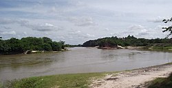
The Tocantins River is a river in Brazil, the central fluvial artery of the country. In the Tupi language, its name means "toucan's beak". It runs from south to north for about 2,450 km. It is not really a branch of the Amazon River, since its waters flow into the Atlantic Ocean alongside those of the Amazon. It flows through four Brazilian states and gives its name to one of Brazil's newest states, formed in 1988 from what was until then the northern portion of Goiás.

Tocantins is one of the 26 states of Brazil. It is the newest state, formed in 1988 and encompassing what had formerly been the northern two-fifths of the state of Goiás. Tocantins covers 277,620.91 square kilometres (107,190.03 sq mi) and had an estimated population of 1,496,880 in 2014. Construction of its capital, Palmas, began in 1989; most of the other cities in the state date to the Portuguese colonial period. With the exception of Araguaína there are few other cities with a significant population in the state. The government has invested in a new capital, a major hydropower dam, railroads and related infrastructure to develop this primarily agricultural area. The state has 0.75% of the Brazilian population and is responsible for 0.5% of the Brazilian GDP.

Maranhão is a state in Brazil. Located in the country's Northeast Region, between latitudes 01º 02' 37" and 10º 15' 41" S and longitudes 41º 47' 44" and 48º 45' 17" W, it has a population of about 7 million and an area of 332,000 km2 (128,000 sq mi). Going clockwise from the north, it borders on the Atlantic Ocean for 2,243 km and the states of Piauí, Tocantins and Pará. The people of Maranhão have a distinctive accent inside the common Northeastern Brazilian dialect. Maranhão is described in books such as The Land of the Palm Trees by Gonçalves Dias and Casa de Pensão by Aluísio Azevedo. The state has 3.4% of the Brazilian population and produces only 1.3% of the Brazilian GDP. it is the poorest state in the country of Brazil.
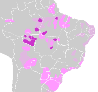
Tupi–Guarani is the name of the most widely distributed subfamily of the Tupian languages of South America. It includes fifty languages, including the best-known languages of the family, Guarani and Old Tupi.

The Jê languages, or Jê–Kaingang languages, are spoken by the Jê, a group of indigenous peoples in Brazil.
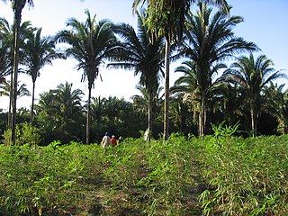
The Maranhão Babaçu forests is a tropical moist broadleaf forest ecoregion of north-central Brazil. The forests form a transition between the equatorial forests of the Amazon biome to the west and the drier savannas and xeric shrublands to the south and east.
The Serra do Tiracambu is a mountain range in Maranhão state of north-central Brazil. The range runs north and south, and forms the divide between the basins of the Gurupí River to the west and the Pindaré River to the east.

The Gurupí River is a river in north-central Brazil which forms the boundary between Maranhão and Pará states. The Gurupí rises in the low hills which separate its basin from that of the Tocantins River to the south, and flows north into the Atlantic Ocean. The Serra do Tiracambu lies to the east, and separates the basin of the Gurupí from that of the Pindaré River.

The Mearim River is a river in Maranhão state of northern Brazil. The river originates in the southern part of Maranhão, and drains north into the Baía de São Marcos, an estuary that also receives the Pindaré and Grajaú rivers, which are sometimes considered tributaries of the Mearim. The lower Mearim is known for its pororoca, or tidal bore.

The golden-winged parakeet is a species of bird in the family Psittacidae, the true parrots.

The Munim River is a river of Maranhão state in northeastern Brazil. It flows north for about 320 kilometres (200 mi) before emptying into the Baía de São José to the south of the state capital. The river has suffered from agricultural pollution and from illegal dredging of sand and gravel for use in construction.

The Guamá River is located in northeast Pará state in north-central Brazil. Its mouth forms the southern border of the state capital, Belém. Its watershed drains an area of 87,389.54 km2 (33,741.29 sq mi). The navigability is feasible in the last 160 km (100 mi) of the river, from the municipality of São Miguel do Guamá to Guajará Bay. Among its tributaries, the Acará, Capim and Moju rivers stand out. In the Guamá River, the pororoca phenomenon usually occurs. The main campus of the Federal University of Pará, near Belém, is located on its right bank. About 75% of the water consumed in Belém comes from this river, which receives 11 streams contaminated by the irregular disposal of urban waste, since only 4, 5% of the home network of the Pará capital is connected to the collecting network.

Gurupi Biological Reserve is a biological reserve in the State of Maranhão, in Brazil.
The Capim River is a river in the state of Pará, Brazil. It is a tributary of the Guamá River.
The Tapajós–Xingu moist forests (NT0168) is an ecoregion in the eastern Amazon basin. It is part of the Amazon biome. The ecoregion extends southwest from the Amazon River between its large Tapajós and Xingu tributaries.

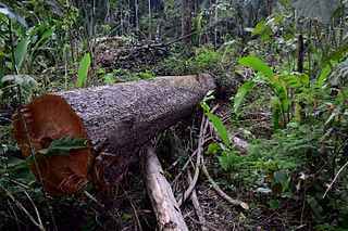
The Xingu–Tocantins–Araguaia moist forests (NT0180) is an ecoregion in the eastern Amazon basin. It is part of the Amazon biome. The ecoregion is one of the most severely degraded of the Amazon region, suffering from large-scale deforestation and selective extraction of timber, particularly along the Trans-Amazonian Highway and in the higher and more populated southern portions.

The Tocantins–Araguaia–Maranhão moist forests (NT0170), also called the Tocantins/Pindaré moist forests, is an ecoregion in the north of Brazil to the south of the mouth of the Amazon River. It is part of the Amazon biome. The ecoregion contains the city of Belém, capital of the state of Pará. It is the most developed part of the Amazon region, and is one of the most severely degraded natural habitats of the region.

The Mato Grosso tropical dry forests (NT0140), also called the Mato Grosso seasonal forests, is an ecoregion in central Brazil to the south of the Amazon region. It contains vegetation in the transition between the Amazon rainforest to the north and the cerrado savanna to the south. The opening of highways through the region has caused rapid population growth, deforestation and pollution.