The Bellefonte Central Railroad was a shortline connecting Bellefonte and State College, Pennsylvania. Constructed in the late 19th century to haul local iron ore to furnaces in the Bellefonte region, it later hauled freight traffic to Penn State and lime for steelmaking from local quarries. The line to State College was abandoned in 1974, and most of the remaining railroad in 1984, but a small portion is still used by the Nittany and Bald Eagle Railroad.
The Mont Alto Rail Road was a railroad in Franklin County, Pennsylvania, originally built to connect the blast furnaces of the Mont Alto Iron Company to the Cumberland Valley Railroad. It was later extended south to reach Waynesboro.
Pine Grove Furnace State Park is a protected Pennsylvania area that includes Laurel and Fuller Lakes in Cooke Township of Cumberland County. The Park accommodates various outdoor recreation activities, protects the remains of the Pine Grove Iron Works (1764), and was the site of Laurel Forge (1830), Pine Grove Park (1880s), and a brick plant (1892). The Park is 8 miles (13 km) from exit 37 of Interstate 81 on Pennsylvania Route 233.
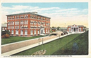
The Cumberland Valley Railroad was an early railroad in Pennsylvania, United States, originally chartered in 1831 to connect with Pennsylvania's Main Line of Public Works. Freight and passenger service in the Cumberland Valley in south central Pennsylvania from near Harrisburg to Chambersburg began in 1837, with service later extended to Hagerstown, Maryland, and then extending into the Shenandoah Valley to Winchester, Virginia. It employed up to 1,800 workers.

The Hanover Branch Railroad Company was a railroad that operated in Pennsylvania in the mid-19th century. The company was incorporated on March 16, 1847, and began operating trains in 1852. It represents the oldest portion of the Western Maryland Railway. It extended from the connection with the Baltimore & Susquehanna Railroad at Hanover Junction, Pennsylvania, to Hanover.
The Gettysburg Railroad was a railway line in Pennsylvania that operated from 1858 to 1870 over the 17-mile (27 km) main line from the terminus in Gettysburg to the 1849 Hanover Junction. After becoming the Susquehanna, Gettysburg & Potomac Railway line in 1870, the tracks between Gettysburg and Hanover Junction became part of the Hanover Junction, Hanover and Gettysburg Railroad in 1874, the Baltimore and Harrisburg Railway in 1886, and the Western Maryland Railway in 1917. Today, its line is part of the CSX Hanover Subdivision.
The Bachman Valley Railroad (BV) was a railroad that operated in Pennsylvania and Maryland, United States, in the 19th century. The 13 mile (21 km) line ran from Valley Junction, Pennsylvania to Ebbvale, Maryland. The railroad was built to transport iron ore to local blast furnaces; it also carried some passengers. The railroad became part of the Western Maryland Railway in 1917.

Round Top is a populated place in Adams County in the U.S. state of Pennsylvania, near Little Round Top. It is notable for two Battle of Gettysburg hospitals, the 1884 Round Top Station, and several battlefield commemorative era attractions such as Round Top Park and the Round Top Museum. The unincorporated community lies on an elevated area of the north-south Taneytown Road with three intersections: at Blacksmith Shop Road to the northeast, Wheatfield Road, and Sachs Road.
The Round Top Branch was an extension of the Gettysburg and Harrisburg Railroad from the Gettysburg borough across the Gettysburg Battlefield to Round Top, Pennsylvania. The branch ran southward from the terminus of the railroad's main line, west of the school and St. Francis Xavier Cemetery, across the field of Pickett's Charge, south of Cemetery Ridge, east of Weikert Hill and Munshower Knoll, and through Round Top to a point between Little Round Top's east base and Taneytown Road. In addition to battlefield tourists, the line carried stone monoliths and statues for monuments during the battlefield's memorial association and commemorative eras and equipment, supplies and participants for Gettysburg Battlefield camps after the American Civil War.

The Gettysburg and Harrisburg Railroad was a railway line of Pennsylvania from Hunter's Run southward to Gettysburg in the 19th century. The north junction was with the South Mountain RR, and a crossing with the Hanover Junction, Hanover and Gettysburg Railroad's westward extension was at Gettysburg. The crossing also served as a junction for westbound trains to transfer southward across the Gettysburg Battlefield via the G. & H. R. R.'s Round Top Branch to the company's Little Round Top Park.
The South Mountain Railroad was a southcentral Pennsylvania railway line for "connecting the Pine Grove works to the Cumberland Valley R. R." and which provided mining and passenger services via a southwest section from Hunter's Run, Pennsylvania, and a northern section from Hunter's Run to the CVRR junction northeast of Carlisle. The northern section merged with the Gettysburg & Harrisburg Railroad line south from Hunter's Run to the Gettysburg Battlefield in 1891 to create the Gettysburg & Harrisburg Railway line, while the branch southwest from Hunter's Run became the Hunter's Run and Slate Belt Railroad line.
The Hunter's Run and Slate Belt Railroad was a railway line from the Hunter's Run junction of the Gettysburg and Harrisburg Railway that ran southwestward along the south side of Mountain Creek to the Pine Grove Iron Works. The line serviced facilities for mining, for manufacturing, and for recreation. Portions of the railbed are a section of the Appalachian Trail as well as the majority of the Cumberland County Biker/Hiker Trail and the entire "Old Railroad Bed Road" that is the southeast border of Pine Grove Furnace State Park.
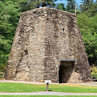
The Pine Grove Iron Works was a smelting facility in southcentral Pennsylvania during the Industrial Revolution. The works is notable for remaining structures that are historical visitor attractions of Pine Grove Furnace State Park, including the furnace stack of the Pine Grove Furnace. The site was listed on the National Register of Historic Places on April 13, 1977 for its significance in architecture and industry. It includes seven contributing buildings, two structures, fourteen sites, and two objects.
The South Mountain Iron Company was the owner of the Pine Grove Furnace in Cumberland County, Pennsylvania, along South Mountain after the 1864 $1,500,000 purchase from Jay Cooke & Company. In 1877 the company was split into separate mining and railway companies, with the latter South Mountain Railway and Mining Company establishing the 1884 South Mountain Railroad between the Pine Grove Iron Works and the Cumberland Valley Railroad's Carlisle Junction then being purchased by the 1891 Gettysburg and Harrisburg Railway company. The real estate of the 1877 South Mountain Mining and Iron Company is now the Pine Grove Furnace State Park and Michaux State Forest after being sold to the Pennsylvania Department of Forestry in 1912-3.
The Gettysburg and Harrisburg Railway was a Pennsylvania line from near Carlisle southward to Gettysburg operated by a subsidiary of the Reading Company. The line also included the Round Top Branch over the Gettysburg Battlefield to Round Top, Pennsylvania until c. 1942.

The Tapeworm Railroad was a railway line planned by Congressman Thaddeus Stevens and nicknamed by opponents ridiculing a lengthy serpentine section around the Green Ridge of South Mountain after an orator compared the path to a tapeworm depiction on a product's packaging. Switchbacks were planned on the west slope at Hughs Forge along the E Br Antietam Creek and on the east slope at Stevens' 1822 Maria Furnace along Toms Creek, with three east slope tunnels through spurs of Jacks Mountain.
Laurel Lake — also known as Laurel Forge Pond — is a water body with recreation area at Pine Grove Furnace State Park. It is located in the eastern part of Cooke Township, Cumberland County.
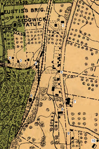
Round Top Station was the southernmost station of the Gettysburg and Harrisburg Railroad and was located west of a blacksmith shop along the Taneytown Road that was in operation in 1880.
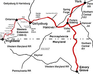
The Western Extension is a Western Maryland section of railway line between Highfield-Cascade, Maryland, and Gettysburg, Pennsylvania. The extension of the Hanover Junction, Hanover and Gettysburg Railroad westward from the Gettysburg Battlefield to Marsh Creek was completed in 1884, crossing the north-south Gettysburg and Harrisburg Railroad and its 1884 Round Top Branch in the borough The line was completed to Orr Station by June 30, 1885, then after an 1886 merger formed the Baltimore and Harrisburg Railway, the 15 mi (24 km) to the mainline at Highland near the Mason–Dixon line was completed in 1888-1889. The B&H leased their line to the Western Maryland Railway until the WM purchased it in 1917. The Western Extension used portions of the 1830s Tapeworm Railroad bed and required construction of the Jacks Mountain Tunnel south of Maria Furnace.
Pine Grove Park was an excursion park on the South Mountain Railroad line. It was located in Cumberland County, Pennsylvania, "in a grove of magnificent trees". It was established by Colonel Jackson C. Fuller c. 1881. It operated from c. 1881 to c. 1904.
