Related Research Articles

Qaanaaq, formerly known as Thule or New Thule, is the main town in the northern part of the Avannaata municipality in northwestern Greenland. It is one of the northernmost towns in the world. The inhabitants of Qaanaaq speak the local Inuktun language and many also speak Kalaallisut and Danish. The town has a population of 646 as of 2020.
The Satellite Control Network (SCN), operated by the United States Space Force's Space Delta 6, provides support for the operation, control, and maintenance of a variety of United States Department of Defense and some non-DoD satellites. This involves continual execution of Telemetry, Tracking, and Commanding (TT&C) operations. In addition, the SCN provides prelaunch checkout and simulation, launch support, and early orbit support while satellites are in initial or transfer orbits and require maneuvering to their final orbit. The SCN provides tracking data to help maintain the catalog of space objects and distributes various data such as satellite ephemeris, almanacs, and other information. It was previously known as the Air Force Satellite Control Network (AFSCN) while under Air Force Space Command's 50th Network Operations Group.

The RCA 474L Ballistic Missile Early Warning System was a United States Air Force Cold War early warning radar, computer, and communications system, for ballistic missile detection. The network of twelve radars, which was constructed beginning in 1958 and became operational in 1961, was built to detect a "mass ballistic missile attack launched on northern approaches [for] 15 to 25 minutes' warning time" also provided Project Space Track satellite data.

Pituffik Space Base, or Thule Air Base/Pituffik Airport, is the United States Space Force's northernmost base, and the northernmost installation of the U.S. Armed Forces, located 750 mi (1,210 km) north of the Arctic Circle and 947 mi (1,524 km) from the North Pole on the northwest coast of the island of Greenland. Thule's arctic environment includes icebergs in North Star Bay, two islands, a polar ice sheet, and Wolstenholme Fjord – the only place on Earth where four active glaciers join together. The base is home to a substantial portion of the global network of missile warning sensors of Space Delta 4, and space surveillance and space control sensors of Space Delta 2, providing space awareness and advanced missile detection capabilities to North American Aerospace Defense Command (NORAD), the United States Space Force, and joint partners.
The United States Air Force's Air Force Satellite Control Facility (AFSCF) was a space command and control unit located at Onizuka AFS, California. It has the distinction of being heavily involved in the world's first reconnaissance satellite program, CORONA. Due to geological hazards, and the terrorism threat from its proximity to a major transportation link, the facility's command and control functions were moved to Schriever AFB, Colorado.
Clear Space Force Station is a United States Space Force radar station for detecting incoming ICBMs and submarine-launched ballistic missiles to NORAD's command center and to provide Space Surveillance data to the United States Space Force. Clear's AN/FPS-123 Upgraded Early Warning Radar is part of the Solid State Phased Array Radar System (SSPARS) which also includes those at Beale AFB, Cape Cod Space Force Station, RAF Fylingdales and Thule Site J. The "historic property" was one of the Alaska World War II Army Airfields and later a Cold War BMEWS site providing NORAD data to Colorado's BMEWS Central Computer and Display Facility (CC&DF).

The 22d Space Operations Squadron is a satellite control unit of the United States Space Force. It is part of Space Delta 6 and is located at Schriever Space Force Base, Colorado. Prior to July 2020 it was part of the 50th Network Operations Group, itself a part of the 50th Space Wing.

The AN/FPS-108 COBRA DANE is a PESA phased array radar installation operated by Raytheon for the United States Space Force at Eareckson Air Station on the island of Shemya, Aleutian Islands, Alaska. The system was built in 1976 and brought online in 1977 for the primary mission of gathering intelligence about Russia's ICBM program in support of verification of the SALT II arms limitation treaty. Its single face 29 m (95 ft) diameter phased array radar antenna 52.7373°N 174.0914°E faces the Kamchatka Peninsula and Russia's Kura Test Range. COBRA DANE operates in the 1215–1400 MHz band.
The 21st Space Wing was the United States Space Force's ground–based missile warning and space control wing. The 21st Space Wing was assigned to Space Operations Command and headquartered at Peterson Air Force Base, Colorado. The 21st Space Wing controlled Peterson Air Force Base, Cheyenne Mountain Air Force Station, Thule Air Base, Clear Air Force Station, Cape Cod Air Force Station, and Cavalier Air Force Station.

On 21 January 1968, an aircraft accident, sometimes known as the Thule affair or Thule accident, involving a United States Air Force (USAF) B-52 bomber occurred near Thule Air Base in the Danish territory of Greenland. The aircraft was carrying four B28FI thermonuclear bombs on a Cold War "Chrome Dome" alert mission over Baffin Bay when a cabin fire forced the crew to abandon the aircraft before they could carry out an emergency landing at Thule Air Base. Six crew members ejected safely, but one who did not have an ejection seat was killed while trying to bail out. The bomber crashed onto sea ice in North Star Bay, Greenland, causing the conventional explosives aboard to detonate and the nuclear payload to rupture and disperse, resulting in radioactive contamination of the area.
Comer's Midden was a 1916 archaeological excavation site near Thule, north of Mt. Dundas in North Star Bay in northern Greenland. It is the find after which the Thule culture was named. The site was first excavated in 1916 by whaling Captain George Comer, ice master of the Crocker Land Expedition's relief team, and of members of Knud Rasmussen's Second Danish Thule Expedition who were in the area charting the North Greenland coast.
Project Iceworm was a top secret United States Army program of the Cold War, which aimed to build a network of mobile nuclear missile launch sites under the Greenland ice sheet. The end goal was to install a vast network of nuclear missile launch sites that could survive a first strike. This was according to documents declassified in 1996. The missiles, that could strike targets within the Soviet Union, were never fielded and necessary consent from the Danish Government to do so was never broached.
The 12th Space Warning Squadron is a United States Space Force ground-based radar used for missile warning, missile defense, and space situation awareness, stationed at Pituffik Space Base, Greenland.
Narsaarsuk is an abandoned settlement on the edge of Bylot Sound in northern Greenland near Pituffik Space Base. The site of the former settlement is contaminated with plutonium after the 1968 Thule Air Base B-52 crash.

The 4734th Air Defense Group is a discontinued United States Air Force organization. Its last assignment was with the 64th Air Division (AD) at Thule Air Base, Greenland, where it was discontinued in 1958. The group was formed in 1957 when ADC assumed responsibility for air defense of Greenland from Northeast Air Command. It controlled a fighter-interceptor squadron at Thule and a squadron operating a radar at nearby Pingarsuak Mountain. It was discontinued in 1958 and its mission transferred to the 64th AD in Newfoundland.

The 4683d Air Defense Wing is a discontinued United States Air Force (USAF) organization. Its last assignment was with Aerospace Defense Command (ADC)'s Goose Air Defense Sector at Thule Air Base, Greenland, where it was discontinued in 1965.
Camp Fistclench was a U.S. Army research camp on and inside the Greenland Ice Cap 200 miles (320 km) east of Thule Air Base. It was in use from 1957 to 1960. It served to test techniques used at the much larger Camp Century.
Thule Air Station is a closed United States Air Force General Surveillance Radar station. It is located 9.2 miles (14.8 km) south of Thule Air Base, Greenland. It was closed in 1965.
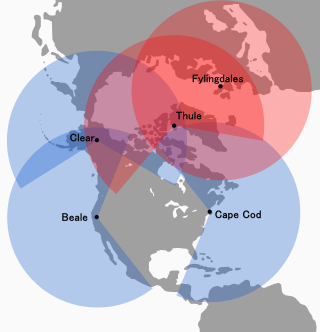
The Solid State Phased Array Radar System is a United States Space Force radar, computer, and communications system for missile warning and space surveillance "at five (5) geographically separated units worldwide including Beale Air Force Base, CA, Cape Cod Space Force Station, MA, Clear Space Force Station, AK, RAF Fylingdales, UK, and Pituffik Space Base, Greenland." SSPARS completed replacement of the RCA 474L Ballistic Missile Early Warning System when the last SSPAR was operational at Clear in 2001, the year SSPARS equipment included:

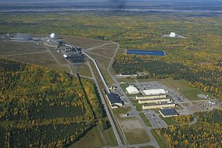
Thule Site J (J-Site) is a United States Space Force (USSF) radar station in Greenland near Pituffik Space Base for missile warning and spacecraft tracking. The northernmost station of the Solid State Phased Array Radar System, the military installation was built as the 1st site of the RCA 474L Ballistic Missile Early Warning System and had 5 of 12 BMEWS radars. The station has the following structures:
References
- ↑ "Missile Sites".
- ↑ "Newcomer's Welcome Package Thule Air Base, Greenland Home of the 821st Air Base Group" (PDF). militaryonesource.mil. Retrieved 2016-10-15.