
Taroko National Park is one of the nine national parks in Taiwan and was named after the Taroko Gorge, the landmark gorge of the park carved by the Liwu River. The park spans Taichung Municipality, Nantou County, and Hualien County. And is located at 972, Taiwan, Hualien County, Xiulin Township, 富世村富世291號
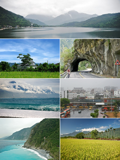
Hualien County is a county on the east coast of Taiwan. It is the largest county by area, yet due to its mountainous terrain, has one of the lowest populations in the country. The county seat and largest city is Hualien City.

Mount Hehuan is a 3,416-metre-high (11,207 ft) mountain in Central Taiwan. The peak lies on the borders of Nantou and Hualien counties and is located within Taroko National Park. Hehuanshan is a popular destination in central Taiwan. The 3,421-metre east peak and 3,422-metre north peak of Hehuanshan are both higher than the main peak.
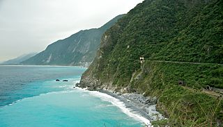
Qingshui Cliff is a 21 kilometer length of coastal cliffs averaging 800 meters above sea level in Xiulin Township, Hualien County, Taiwan. The tallest peak, Qingshui Mountain, rises 2408 meters directly from the Pacific Ocean. The cliff is located at the southern part of the Suhua Highway that connects the counties of Yilan and Hualien in eastern Taiwan. It is considered to be a very scenic area and is the highest coastal cliff in Taiwan.

Shoufeng Township is a rural township in Hualien County, Taiwan. The township sits in the north segment of Huadong Valley between Taiwan's Central Range and Hai'an Range near the Pacific Ocean. The township is best known as the location of National Dong Hwa University (NDHU), a university and famous tourist attraction in East Taiwan.

Qilai Mountain is a mountain in Xiulin, Hualien, Taiwan. Its highest point of the range, the Northern Peak, is 3,607 m (11,834 ft) above sea level. It is named after the Sakizaya people.

Chishang Township is a rural township in Taitung County, Taiwan.

The Coastal Mountain Range, also known as the Hai'an Range, is a mountain range situated on the eastern coast of the island of Taiwan, and spans the border between Hualien and Taitung Counties. Coastal Mountain Range is part of the Philippine Mobile Belt which was formed over 400 million years ago by the collision and compression of Philippine Mobile Belt and Eurasian Plate. The geological structure is composed of soft sediments which have weaker anti-erosion property and are vulnerable to wind.
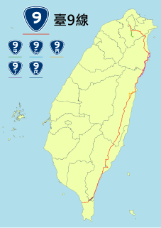
Provincial Highway No. 9 is an important highway cross the eastern Taiwan from Taipei City to Fangshan, Pingtung, Pingtung County. This provincial highway, at 476.1 km long, is the longest provincial highway in Taiwan and passes the regions of Taipei City, New Taipei City, Yilan County, Hualien County, Taitung County and Pingtung County.

The National Dong Hwa University is founded as a Public Research University located in Hualien County, Taiwan.
NDHU is a comprehensive research university considered the high prestigious university in Eastern Taiwan, offering the 3rd widest range of disciplines among universities in Taiwan. Including the sciences, engineering, design, environment, law, arts, social sciences, education science, marine science, music, and business. The University consists of 8 colleges, 38 departments, 56 graduate institutes, some research centers, and serves over 10,000 undergraduate and graduate students.

The Farglory Ocean Park or Hualien Ocean Park is a water theme park in Shoufeng Township, Hualien, Taiwan. It is the first marine theme park in Taiwan.

Tzu Chi University of Science and Technology is a private university in Hualien City, Hualien County, Taiwan.

The National Airborne Service Corps is the agency of the Ministry of the Interior of the Republic of China (Taiwan) responsible for executing and providing support for search and rescue, disaster relief, emergency medical service, transportation, monitoring, reconnaissance and patrol in Taiwan.

The Hualien County Council is the elected county council of Hualien County, Republic of China. The council composes of 33 councilors lastly elected through the 2018 Republic of China local election on 24 November 2018.

The Bihai Power Plant is a hydroelectric power plant in Xiulin Township, Hualien County, Taiwan.

The Xiangde Temple is a temple in Xiulin Township, Hualien County, Taiwan.

The Pine Garden is a former Japanese military office in Hualien City, Hualien County, Taiwan.
The Rareseed Ranch is a tourist attraction ranch in Wuhe Village, Ruisui Township, Hualien County, Taiwan.

The Shimen Mountain is a mountain in Ren'ai Township, Nantou County and Xiulin Township, Hualien County of Taiwan.


