Homestead is a city within Miami-Dade County in the U.S. state of Florida, between Biscayne National Park to the east and Everglades National Park to the west. The population was 80,737 as of the 2020 census. Homestead is primarily a Miami suburb and a major agricultural area. It is a principal city of the Miami metropolitan area, which was home to an estimated 6,012,331 people at the 2015 census. It is located approximately 26 miles (42 km) southwest of Miami, and 25 miles (40 km) northwest of Key Largo.
Pinecrest is a suburban village in Miami-Dade County, Florida, United States. As of the 2020 census the population was 18,388.

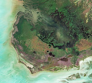
Biscayne National Park is an American national park located south of Miami, Florida in Miami-Dade County. The park preserves Biscayne Bay and its offshore barrier reefs. Ninety-five percent of the park is water, and the shore of the bay is the location of an extensive mangrove forest. The park covers 172,971 acres and includes Elliott Key, the park's largest island and northernmost of the true Florida Keys, formed from fossilized coral reef. The islands farther north in the park are transitional islands of coral and sand. The offshore portion of the park includes the northernmost region of the Florida Reef, one of the largest coral reefs in the world.

Flamingo is the southernmost headquarters of Everglades National Park, in Monroe County, Florida, United States. Flamingo is one of the two end points of the 99-mile (159-km) Wilderness Waterway, and the southern end of the only road through the park from Florida City. It began as a small coastal settlement on the eastern end of Cape Sable on the southern tip of the Florida peninsula, facing Florida Bay. The actual town of Flamingo was located approximately 4+1⁄2 miles west of the current Flamingo campground area. All that remains of the former town are a few remnants of building foundations, and it is considered a ghost town.

Everglades National Park is an American national park that protects the southern twenty percent of the original Everglades in Florida. The park is the largest tropical wilderness in the United States and the largest wilderness of any kind east of the Mississippi River. An average of one million people visit the park each year. Everglades is the third-largest national park in the contiguous United States after Death Valley and Yellowstone. UNESCO declared the Everglades & Dry Tortugas Biosphere Reserve in 1976 and listed the park as a World Heritage Site in 1979, and the Ramsar Convention included the park on its list of Wetlands of International Importance in 1987. Everglades is one of only three locations in the world to appear on all three lists.

The Maumee River is a river running in the United States Midwest from northeastern Indiana into northwestern Ohio and Lake Erie. It is formed at the confluence of the St. Joseph and St. Marys rivers, where Fort Wayne, Indiana has developed, and meanders northeastwardly for 137 miles (220 km) through an agricultural region of glacial moraines before flowing into the Maumee Bay of Lake Erie. The city of Toledo is located at the mouth of the Maumee. The Maumee was designated an Ohio State Scenic River on July 18, 1974. The Maumee watershed is Ohio's breadbasket; it is two-thirds farmland, mostly corn and soybeans. It is the largest watershed of any of the rivers feeding the Great Lakes, and supplies five percent of Lake Erie's water.

The Wabash and Erie Canal was a shipping canal that linked the Great Lakes to the Ohio River via an artificial waterway. The canal provided traders with access from the Great Lakes all the way to the Gulf of Mexico. Over 460 miles long, it was the longest canal ever built in North America.

Biscayne Bay is a lagoon with characteristics of an estuary located on the Atlantic coast of South Florida. The northern end of the lagoon is surrounded by the densely developed heart of the Miami metropolitan area while the southern end is largely undeveloped with a large portion of the lagoon included in Biscayne National Park.

The Florida East Coast Railway is a Class II railroad operating in the U.S. state of Florida, currently owned by Grupo México.

The Port of Miami, styled as PortMiami but formally the Dante B. Fascell Port of Miami, is a major seaport located in Biscayne Bay at the mouth of the Miami River in Miami, Florida. It is the largest passenger port in the world and one of the largest cargo ports in the United States.

Hamilton Disston was an industrialist and real-estate developer who purchased 4 million acres (16,000 km²) of Florida land in 1881, an area larger than the state of Connecticut, and reportedly the most land ever purchased by a single person in world history. Disston was the son of Pennsylvania-based industrialist Henry Disston who formed Disston & Sons Saw Works, which Hamilton later ran and which was one of the largest saw manufacturing companies in the world.

The Miami Beach Botanical Garden is a 2.6 acres (1.1 ha) urban green space in Miami Beach, Florida founded in 1962. It was transformed in 2011 with a $1.2 million landscape renovation designed by South Florida landscape architect Raymond Jungles. The new landscape showcases native Florida plants and trees including bromeliads, palms, cycad, orchids and many others. There is a Japanese garden, native garden and bioswale, and water gardens including ponds, fountains, and a wetland with mangrove and pond apple trees. The renovation also expanded the Great Lawn area for corporate and social events, established a plant nursery and event plaza, and enhanced the night-time lights, entrance gate, and pathways.
The Miami-Dade Zoological Park and Gardens, also known as Zoo Miami, is a zoological park and garden near Miami and is the largest zoo in Florida. Originally established in 1948 at Crandon Park in Key Biscayne, Zoo Miami relocated in 1980 as Miami MetroZoo to the former location of the Naval Air Station Richmond, southwest of Miami in southern unincorporated Miami-Dade County, surrounded by the census-designated places of Three Lakes (north), South Miami Heights (south), Palmetto Estates (east) and Richmond West (west).
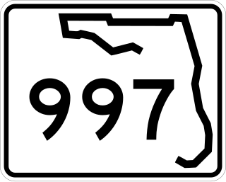
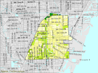
State Road 997, also known as Krome Avenue and West 177th Avenue is a 36.7-mile-long (59.1 km) north–south state highway in western Miami-Dade County, Florida. It runs from State Road 998 in Homestead north across U.S. Route 41 to U.S. Route 27 near Countyline Dragway, just south of the Broward County line. Its main use is as a bypass around the western side of Miami, linking the routes that run southwest, west and northwest from that city. The road passes through newer suburbs in the southern third of its length, while the northern two thirds of the highway traverse the eastern edge of the Everglades.
Cape Sable is the southernmost point of the United States mainland and mainland Florida. It is located in southwestern Florida, in Monroe County, and is part of the Everglades National Park.

Arch Creek was an early settlement in Miami-Dade County, Florida, in present-day metropolitan Miami. Tequesta Indians thrived here before the first Europeans arrived in the early 16th century. The name is derived from the 40 feet (12 m) long natural limestone bridge that spanned the creek until 1973. It is part of the Arch Creek Memorial Park at 1855 Northeast 135th Street, on Biscayne Boulevard. It was added to the U.S. National Register of Historic Places on July 15, 1986.

Belle Isle is a neighborhood in the city of Miami Beach on an island in Biscayne Bay, Florida, United States. It is the easternmost of the Venetian Islands, a chain of artificial islands in Biscayne Bay in the cities of Miami and Miami Beach. It is home to apartment buildings, a portion of the Venetian Causeway, a city of Miami Beach park, and a hotel. It is between Rivo Alto Island and the main barrier island of Miami Beach.

The Hialeah Park Race Track is a historic racetrack in Hialeah, Florida. Its site covers 40 square blocks of central-east side Hialeah from Palm Avenue east to East 4th Avenue, and from East 22nd Street on the south to East 32nd Street on the north. On March 5, 1979, it was added to the U.S. National Register of Historic Places. Another listing for it was added in 1988. The Hialeah Park Race Track is served by the Miami Metrorail at the Hialeah Station at Palm Avenue and East 21st Street.

A national push for expansion and progress toward the latter part of the 19th century stimulated interest in draining the Everglades, a region of tropical wetlands in southern Florida, for agricultural use. According to historians, "From the middle of the nineteenth century to the middle of the twentieth century, the United States went through a period in which wetland removal was not questioned. Indeed, it was considered the proper thing to do."

The Port of Key West is a port in Key West, Florida. It includes Key West Bight, Garrison Bight at City Marina, as well as three docks utilized by cruise ships.