
Camp Floyd State Park Museum is a state park in the Cedar Valley in Fairfield, Utah, United States. The park includes a small part of the former Camp Floyd site, the Stagecoach Inn, and the Fairfield District School.

The Salt Lake City Council Hall is currently home to offices of the Utah Office of Tourism and the Utah Film Commission and is located on Capitol Hill in Salt Lake City, Utah. Built in 1864-66, the building is historically important as the Old Salt Lake City Hall or just Old City Hall from 1866 to 1894. It was designated a National Historic Landmark in 1975, as an emblem of the conflicts between the governments of the Utah Territory and the United States in the 19th century.
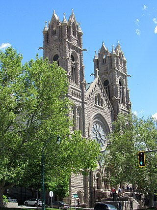
The Cathedral of the Madeleine is a Roman Catholic church in Salt Lake City, Utah, United States. It was completed in 1909 and is the cathedral, or mother church, of the Diocese of Salt Lake City. It is the only cathedral in the U.S. under the patronage of St. Mary Magdalene.

Old Las Vegas Mormon Fort State Historic Park is a state park of Nevada. It contains the Old Mormon Fort, the first structure built by people of European heritage in what would become Las Vegas fifty years later. In present-day Las Vegas, the site is at the southeast corner of Las Vegas Boulevard and Washington Avenue, less than one mile north of the downtown area and Fremont Street. This is the only U.S. state park located in a city that houses the first building ever built in that city. The fort was listed on the National Register of Historic Places on February 1, 1972. The site is memorialized with a tablet erected by the Church of Jesus Christ of Latter-day Saints in 1997, along with Nevada Historical Marker #35, and two markers placed by the Daughters of Utah Pioneers.

The Utah Territorial Statehouse, officially Territorial Statehouse State Park Museum, is a state park in Fillmore, Utah. The museum and park preserves the original seat of government for Utah Territory before the capital was moved to Salt Lake City in 1856. Built from 1852 to 1855, the statehouse was initially intended as a larger structure, but only the south wing was completed before the project was abandoned due to lack of federal funding. After its construction, the Utah Territorial Legislative Assembly met in the building for only one full session and parts of two others.

Fort Douglas was established in October 1862, during the American Civil War, as a small military garrison about three miles east of Salt Lake City, Utah. Its purpose was to protect the overland mail route and telegraph lines along the Central Overland Route. It was officially closed in 1991 pursuant to BRAC action. A small portion of the fort remains in active military use as the Stephen A. Douglas Armed Forces Reserve Center, although it is expected the reserve center will be relocated in the next few years, after the state of Utah provided funds for the purpose in 2023.

Emigration Canyon is a metro township and canyon in Salt Lake County, Utah, United States, located east of Salt Lake City in the Wasatch Range. Beginning at the southern end of the University of Utah, the canyon itself heads east and northeast between Salt Lake City and Morgan County. The boundaries of the metro township do not extend to the county line, nor do they encompass all of Emigration Canyon, as parts of it are within Salt Lake City. As of the 2020 census, the population was 1,466.

The Cottonwood Paper Mill is an abandoned stone structure located at the mouth of Big Cottonwood Canyon in Cottonwood Heights, Utah. It was listed on the National Register of Historic Places in 1971.
Fort Utah was the original white settlement at Provo, Utah, United States, and was established March 12, 1849. The original settlers were President John S. Higbee and about 30 families or 150 persons that were sent from Salt Lake City to Provo by President Brigham Young. Several log houses were erected, surrounded by a 14-foot (4.3 m) palisade 20 by 40 rods in size, with gates in the east and west ends, and a middle deck, for a cannon. The fort was first located west of town, but was moved to Sowiette Park in April 1850.

Liberty Park is a popular public urban park in Salt Lake City, Utah. It is the city's second-largest public park, at 80 acres (32 ha), being surpassed only by Sugar House Park which has 110.5 acres (44.7 ha). The park features a pond with two islands, and is also the location of Tracy Aviary. The park is listed on the National Register of Historic Places (NRHP) and it includes the Isaac Chase Mill, which is also NRHP-listed.

The following is an alphabetical list of articles related to the U.S. state of Utah.

This is a list of the National Register of Historic Places listings in Salt Lake County, Utah, except those in Salt Lake City. Listings for Salt Lake City can be found here.

This is a list of the National Register of Historic Places listings in Salt Lake City, Utah.
The Brigham Young Oil Well is an oil seep near Evanston, Wyoming, United States that was discovered and used by the original Mormon expedition to Utah under the leadership of Brigham Young. The party used the oil on the surface to lubricate wagon wheel hubs, as polish, and as a poultice. After the party reached Great Salt Lake, a group returned and dug a well at the seep for other pioneers. The well served until 1869 when the Union Pacific Railroad brought petroleum to Salt Lake City.
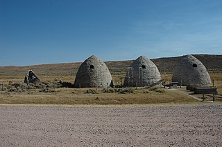
The Piedmont Charcoal Kilns in Piedmont, Wyoming, are a remnant of a once-extensive charcoal-making industry in southwestern Wyoming. The kilns were built by Moses Byrne around 1869 near the Piedmont Station along the Union Pacific Railroad. The three surviving beehive-shaped kilns were built of local sandstone about 30 feet (9.1 m) in circumference and about 30 feet (9.1 m) high, with 24-inch-thick (61 cm) walls. A granite marker reads:
Charcoal Kilns were built by Moses Byrne, 1869, to supply the pioneer smelters in the Utah Valley.

Erected in 1930, the Sugar House Monument has long stood as a testament to the hard work of early Salt Lake pioneers making the valley sustainable.

The Perry and Agnes Wadsworth Fitzgerald House, at 1160 East Pioneer Road in Draper, Utah, United States, was built in 1870 as the home for Perry Fitzgerald's third polygamous wife Agnes, who had 13 children. It was listed on the National Register of Historic Places in 2004.

The Warehouse District of Salt Lake City, Utah, is a historic district on the city's west side. The area has been occupied by artists, and worked on by developers. A small portion of its area was added to the National Register of Historic Places in 1982, and the listing was greatly enlarged by a boundary increase in 2016.

The Judge Building, is a historic commercial building in Salt Lake City, Utah, United States, that is listed on the National Register of Historic Places (NRHP).
The University Neighborhood Historic District is a 180 acres (73 ha) historic district near the University of Utah campus in northeastern Salt Lake City, Utah, United States, that was listed on the National Register of Historic Places in 1995.


 Memorial