Washington Square Park (Salt Lake City)

Last updated
Washington Square
Washington Square Entrance Sign - Salt Lake City, Utah - 9 August 2020.jpg
Washington Square entrance sign, August 2020
Washington Square Park (Salt Lake City)
Type Urban park
Location Salt Lake City, Utah
United States
Coordinates 40°45′36″N111°53′13″W / 40.76000°N 111.88694°W / 40.76000; -111.88694
Area10 acres (4.0  ha)
Operated bySalt Lake City Parks Division

Washington Square, or Washington Square Park, [1] is a public park in Salt Lake City, Utah, United States. [2] The park surrounds the Salt Lake City and County Building, which houses Salt Lake City's government.

Contents

The block containing the park was designated a public square in the initial 1847 survey of Salt Lake City. Early on it was used as a campground for newly arrived Mormon pioneers, and wagon trains headed to other areas of the Western United States. Later it hosted a skating pond, circuses, markets, and sports fields. In the 1890s, the Salt Lake City and County Building was constructed in the center of the block. Currently, several of the city's cultural celebrations and events are centered around the square.

Description

Washington Square includes the entire city block that is bounded on the north by 400 South (University Boulevard/Utah State Route 186), on the east by 200 East, on the south by 500 South (Cesar E. Chavez Boulevard), and on the west by State Street (U.S. Route 89). [3]

Like other blocks in Salt Lake City's original grid, Washington Square is 10 acres (4.0  ha ). [4] The Salt Lake City and County Building, alone in the center of the block, takes up relatively little space. Trees, walkways, and statues surround the building, creating the current park.

Several of Salt Lake City's cultural events take place at Washington Square, and often 200 East Street between it and Library Square is blocked off to create one large event plaza. To protect the lawn and trees, the large celebrations are, as of 2019, limited to four a year (including the Living Traditions Festival, Utah Arts Festival, Utah Pride Festival, and Days of '47 Pioneer Celebration). [4]

History

Fountain in Washington Square, April 2021 Salt Lake City, Utah (2021) - 205.jpg
Fountain in Washington Square, April 2021

On August 2, 1847, just weeks after the first Mormon settlers arrived in the Salt Lake Valley, Henry Sherwood and Orson Pratt began to survey and layout Salt Lake City, beginning at the newly established Salt Lake meridian. [5] In the survey, four blocks were designated public squares, including block 38, which would later be known as Washington Square. [6] (The other public squares in the early surveys became Pioneer Park, Union Square (currently the site of West High School), and Tenth Ward Square (currently the site of Trolley Square).)

Early names for the square included Eighth Ward Square, Emigration Square, and Washington Square. From about 1859 until the mid 1860s, the square served as the campground for newly arrived Mormon pioneers. [7] Other emigrants passing through the city on their way to areas further west, such as California, also made use of the grounds. [8] On July 23, 1947, the Daughters of Utah Pioneers (DUP) dedicated a monument in the square to commemorate its usage as a pioneer campground. [9] The DUP monument erroneously claims the first group of Mormon pioneers who arrived in July 1847 camped at the square. Rather, this group spent their first night in the valley near First Encampment Park, and the following day traveled to the site of the future downtown Salt Lake City, where they camped for a few nights near 300 South and State Street, [8] before constructing a fort at the site of Pioneer Park.

DUP monument commemorating the square's usage as a pioneer campground Pioneer Camping Grounds.jpg
DUP monument commemorating the square's usage as a pioneer campground

Later the square became the site of a skating pond, was used as circus grounds, hosted a marketplace for hay, and for a time included a baseball park. Then finally, in the 1890s, the City and County Building was constructed in the center of the block. [6]

On February 21, 1957 the Salt Lake City Commission passed a resolution officially naming the grounds "Washington Square" in honor of one of its older names (which had been used in honor of US President George Washington). [10] Some sources indicate the block at been named "Washington Square" on December 12, 1865 by the Salt Lake City Council, and simply needed reconfirmation in 1957. [6] [11]

One notable gathering in the park happened on June 16, 1995, when 40,000–50,000 people congregated on the west side of the City and County Building to watch, live on a large screen, the International Olympic Committee (IOC) announce the bid winner to host the 2002 Winter Olympics. When IOC chairman Juan Antonio Samaranch read the winning city—Salt Lake City—the crowd at Washington Square cheered loudly for minutes, drowning out the rest of Samaranch's words. [12] [13] As part of the 2002 Olympic torch relay, a special cauldron was set up on the square, which was lit by Paralympic athlete Chris Waddell during a celebration in front of the City and County Building on February 7, 2002. [14] The square was also the site of concerts and other entertainment during the games.

See also

Related Research Articles

<span class="mw-page-title-main">Salt Lake City</span> State capital and largest city of Utah, United States

Salt Lake City, often shortened to Salt Lake or SLC, is the capital and most populous city of the U.S. state of Utah. It is the seat of Salt Lake County, the most populous county in the state. The city is the core of the Salt Lake City Metropolitan Statistical Area (MSA), which had a population of 1,257,936 at the 2020 census. Salt Lake City is further situated within a larger metropolis known as the Salt Lake City–Ogden–Provo Combined Statistical Area, a corridor of contiguous urban and suburban development stretched along a 120-mile (190 km) segment of the Wasatch Front, comprising a population of 2,746,164, making it the 22nd largest in the nation. With a population of 200,133 in 2020, it is the 117th most populous city in the United States. It is also the central core of the larger of only two major urban areas located within the Great Basin.

<span class="mw-page-title-main">South Jordan, Utah</span> City in Salt Lake County, Utah, United States

South Jordan is a city in south central Salt Lake County, Utah, United States, 18 miles (29 km) south of Salt Lake City. Part of the Salt Lake City metropolitan area, the city lies in the Salt Lake Valley along the banks of the Jordan River between the 10,000-foot (3,000 m) Oquirrh Mountains and the 11,000-foot (3,400 m) Wasatch Mountains. The city has 3.5 miles (5.6 km) of the Jordan River Parkway that contains fishing ponds, trails, parks, and natural habitats. The Salt Lake County fair grounds and equestrian park, 67-acre (27 ha) Oquirrh Lake, and 37 public parks are located inside the city. As of 2020, there were 77,487 people in South Jordan.

<span class="mw-page-title-main">Mormon Battalion</span> Military unit

The Mormon Battalion was the only religious unit in United States military history in federal service, recruited solely from one religious body and having a religious title as the unit designation. The volunteers served from July 1846 to July 1847 during the Mexican–American War of 1846–1848. The battalion was a volunteer unit of between 534 and 559 Latter-day Saint men, led by Mormon company officers commanded by regular U.S. Army officers. During its service, the battalion made a grueling march of nearly 1,950 miles from Council Bluffs, Iowa, to San Diego, California.

<span class="mw-page-title-main">Pioneer Day</span> Holiday in Utah, United States

Pioneer Day is an official holiday celebrated on July 24 in the American state of Utah, with some celebrations taking place in regions of surrounding states originally settled by Mormon pioneers. It commemorates the entry of Brigham Young and the first group of Mormon pioneers into the Salt Lake Valley on July 24, 1847, where the Latter-day Saints settled after being forced from Nauvoo, Illinois, and other locations in the eastern United States. Parades, fireworks, rodeos, and other festivities help commemorate the event. Similar to July 4, many local and all state-run government offices and many businesses are closed on Pioneer Day.

<span class="mw-page-title-main">Temple Square</span> United States historic place

Temple Square is a 10-acre (4.0 ha) complex, owned by the Church of Jesus Christ of Latter-day Saints, in the center of Salt Lake City, Utah. The usage of the name has gradually changed to include several other church facilities that are immediately adjacent to Temple Square. Contained within Temple Square are the Salt Lake Temple, Salt Lake Tabernacle, Salt Lake Assembly Hall, the Seagull Monument, and two visitors' centers. The square was designated a National Historic Landmark District in 1964, recognizing the Mormon achievement in the settlement of Utah.
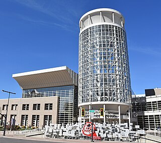
<span class="mw-page-title-main">Buildings and sites of Salt Lake City</span>

Salt Lake City, Utah has many historic and notable sites within its immediate borders. Although the entire Salt Lake City metropolitan area is often referred to as "Salt Lake City", this article is concerned only with the buildings and sites within the official city limits of Salt Lake City.

<i>Deseret News</i> Newspaper published by the LDS Church

The Deseret News is a multi-platform newspaper based in Salt Lake City, published by Deseret News Publishing Company, a subsidiary of Deseret Management Corporation, which is owned by the Church of Jesus Christ of Latter-day Saints. Founded in 1850, it was the first newspaper to be published in Utah. The publication's name is from the geographic area of Deseret identified by Utah's pioneer settlers, and much of the publication's reporting is rooted in that region.

<span class="mw-page-title-main">Salt Lake City and County Building</span> Historic building in Salt Lake City, Utah, U.S.

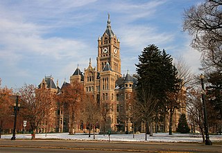
The Salt Lake City and County Building, usually called the "City-County Building", is the seat of government for Salt Lake City, Utah. The historic landmark formerly housed offices for Salt Lake County government as well, hence the name.

<span class="mw-page-title-main">Salt Lake City Public Library</span> Public library in Utah, United States

The Salt Lake City Public Library system's main branch building is an architecturally unique structure in Salt Lake City, Utah. It is located at 210 East, 400 South, across from the Salt Lake City and County Building and Washington Square.

<span class="mw-page-title-main">Downtown Salt Lake City</span>

Downtown is the oldest district in Salt Lake City, Utah, United States. The grid from which the entire city is laid out originates at Temple Square, the location of the Salt Lake Temple.

<span class="mw-page-title-main">Martin's Cove</span> United States historic place

Martin's Cove is a historic site in Wyoming. The 933 acre (3.8 km²) cove is located 55 miles (89 km) southwest of Casper, Wyoming, in Natrona County. It is located on the Mormon Trail and is also part of the North Platte-Sweetwater segment of the Oregon Trail. The Cove was listed in the National Register of Historic Places on March 8, 1977.

<span class="mw-page-title-main">Utah Territorial Statehouse</span> United States historic place

The Utah Territorial Statehouse, officially Territorial Statehouse State Park Museum, is a state park in Fillmore, Utah. The museum and park preserves the original seat of government for Utah Territory before the capital was moved to Salt Lake City in 1856. Built from 1852 to 1855, the statehouse was initially intended as a larger structure, but only the south wing was completed before the project was abandoned due to lack of federal funding. After its construction, the Utah Territorial Legislative Assembly met in the building for only one full session and parts of two others.

<span class="mw-page-title-main">Ogden Utah Temple</span> Church of Jesus Christ of Latter-day Saints temple

The Ogden Utah Temple is the sixteenth constructed and fourteenth operating temple of the Church of Jesus Christ of Latter-day Saints. Located in Ogden, Utah, it was originally built with a modern, single-spire design very similar to the Provo Utah Temple. During a renovation completed in 2014, the exterior and interior were extensively changed.

<span class="mw-page-title-main">Daughters of Utah Pioneers</span> Historical organization focusing on Utah, United States

The International Society Daughters of Utah Pioneers is a women's organization dedicated to preserving the history of the original settlers of the geographic area covered by the State of Deseret and Utah Territory, including Mormon pioneers. The organization is open to any woman who is: (1) A direct-line descendant or legally adopted direct-line descendant with a pioneer ancestor; (2) the pioneer ancestor is a person who traveled to or through the geographic area covered by the State of Deseret/Utah Territory between July 1847 and 10 May 1869 ; (3) over the age of eighteen, and of good character. Travel through the geographic area covered by the State of Deseret/Utah Territory can be either east to west, west to east, north to south, or south to north.

<span class="mw-page-title-main">History of Utah</span>

The History of Utah is an examination of the human history and social activity within the state of Utah located in the western United States.

<span class="mw-page-title-main">Days of '47 Parade</span>

The Days of '47 Parade is an annual parade presented by The Days of '47, Inc. The three-hour event is held in Salt Lake City starting at 9:00 a.m. MDT on or around July 24, the same day as Pioneer Day, a Utah state holiday.

<span class="mw-page-title-main">Fort Utah</span> Settlement in Utah, United States

Fort Utah was the original white settlement at Provo, Utah, United States, and was established March 12, 1849. The original settlers were President John S. Higbee and about 30 families or 150 persons that were sent from Salt Lake City to Provo by President Brigham Young. Several log houses were erected, surrounded by a 14-foot (4.3 m) palisade 20 by 40 rods in size, with gates in the east and west ends, and a middle deck, for a cannon. The fort was first located west of town, but was moved to Sowiette Park in April 1850.

<span class="mw-page-title-main">Salt Lake City Intermodal Hub</span> Intermodal transit center in Utah, USA

The Salt Lake City Intermodal Hub is a multi-modal transportation hub in Salt Lake City, Utah, United States served by the Blue Line of UTA's TRAX light rail system that operates in Salt Lake County and by the FrontRunner, UTA's commuter rail train that operates along the Wasatch Front with service from Ogden in central Weber County through Davis County, Salt Lake City, and Salt Lake County to Provo in central Utah County. Service at the intermodal hub is also provided by Amtrak, and Greyhound Lines, as well as UTA local bus service.

<span class="mw-page-title-main">Venues of the 2002 Winter Olympics</span>

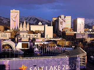
The 2002 Winter Olympic Games were held in and around Salt Lake City, United States from February 8 to 24, 2002, and the Paralympics from March 7 to 16, 2002. The sporting events were held in ten competitive venues, while non-competitive events, such as the opening ceremony, were held in six other venues. Three venues were also created for training purposes. All Olympic venues were scattered throughout Northern Utah and the Wasatch Front.

<span class="mw-page-title-main">Mormon Trail Center at Winter Quarters</span>

The Mormon Trail Center at Winter Quarters is a museum and visitors' center of the Church of Jesus Christ of Latter-day Saints located in the Florence neighborhood of Omaha, Nebraska, United States. The museum interprets the story of the Mormon Trail along with the history of a temporary Mormon settlement known as Winter Quarters, which was located in the Florence area between 1846–1848.

References

  1. "Washington Square". slc.gov. Salt Lake City. Archived from the original on 30 April 2021. Retrieved 22 May 2021.
  2. Giottonini, Jerad (3 Jan 2020). "Protesters occupy Washington Square Park, standing with homeless population". abc4.com. KTVX. Archived from the original on 1 May 2021. Retrieved 22 May 2021.
  3. Google (22 May 2021). "Washington Square Park" (Map). Google Maps . Google. Retrieved 22 May 2021.
  4. 1 2 Salt Lake City: Parks & Public Lands (April 2019). Salt Lake City Parks & Public Lands Needs Assessment (PDF) (Report). Retrieved March 23, 2024.
  5. Grunder, Rick; Cohen, Paul E. (2019). "Cartography and the Founding of Salt Lake City". Utah Historical Quarterly . 87 (3): 182–199. Retrieved March 21, 2024.
  6. 1 2 3 Koenig, Bob (June 2, 1965). "Historic Roots: Washington Square". Deseret News . Salt Lake City. pp. B1, B11. Retrieved March 21, 2024.
  7. Woods, Fred E. (2011). "The Arrival of Nineteenth-Century Mormon Emigrants in Salt Lake City". In Esplin, Scott C.; Alford, Kenneth L. (eds.). Salt Lake City: The Place Which God Prepared. Provo, Utah: Religious Studies Center. pp. 203–229. ISBN   978-0-8425-2799-6.
  8. 1 2 Kreutzer, Lee (2010). National Historic Trails Auto Tour Route Interpretive Guide: Utah — Crossroads of the West (PDF). Salt Lake City: National Park Service, National Trails Office—Intermountain Region. pp. 80–81.
  9. "DUP Erect Monument At First S. L. Campsite". Deseret News . Salt Lake City. July 24, 1947. p. 9. Retrieved March 21, 2024.
  10. "It's Now Official–Square Named After Washington". Deseret News . Salt Lake City. February 21, 1957. p. 2B. Retrieved March 21, 2024.
  11. "Century Date Is Observed". Deseret News . Salt Lake City. December 14, 1965. p. B11. Retrieved March 21, 2024.
  12. Baltezore, Jay; Fisher, Claire (June 17, 1995). "Agonizing Olympic Wait Ends in Jubilation". The Salt Lake Tribune . Salt Lake City. pp. B-1, B-3.
  13. Adams, Brooke (June 17, 1995). "A Celebration That's Worth Its 'Salt...'". Deseret News . Salt Lake City. Retrieved March 23, 2024.
  14. Baird, Joe (February 8, 2002). "Cold weather, warm cheers: Olympic torch rolls in SLC". The Salt Lake Tribune . Salt Lake City. pp. A1, A4.