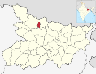
Sheohar is an administrative district in the state of Bihar in India. The district headquarters are located at Sheohar, and the district is a part of Tirhut Division. This district was carved out of Sitamarhi district in 1994 due to the extreme efforts of Raghunath Jha, former Union Minister. Eminent Hindi Novelist, Dr. Bhagwati Sharan Mishra was the first District magistrate of Sheohar. Sivas used to have a guest house in the Mehsi town of his time, which is still located in the name of Raja Bazar in East Champaran.The district occupies an area of 443 km² and has a population of 656,246. Sheohar is known for its greenery and cleanliness. Cadamba and teak are the principal trees of this district. Nilgai or blue bull is the regional animal of this area.

West Champaran is an administrative district in the state of Bihar in India, located just 60 km (37 mi) west of Birgunj. It is the largest district in Bihar with an area of 5,228 km²(2,019sq mi). It is a part of Tirhut Division. The district headquarters are located in Bettiah. The district is known for its open border with Nepal. One of the major location in West Champaran is Kumar Bagh for SAIL Special Processing Unit and Bhitiharwa where Mahatma Gandhi started Satyagrah Aandolan.
East Champaran is an administrative district in the state of Bihar in India.The district headquarters are located at Motihari. Prior to 1st Dec 1977, there was a single district called "Champaran". On 1 December 1977, the district was divided into 2 parts East Champaran and West Champaran. In early days the land of East Chamapran was ruled by different kingdoms as Videha, Sunga, Kanvas. It is also believed that Champaran used to be a major part of King Janak's empire. Mahatma Gandhi Started his famous Satyagraha movement from here. Proper district Entry Point Mangrahi, Bakhari in Mehsi Champaran

Bettiah is a city and administrative headquarters of West Champaran district - (Tirhut), near Indo-Nepal border, 225 kilometres (140 mi) north-west of Patna, in Bihar state of India.
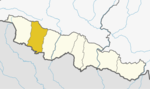
Bara District is one of the seventy–seven districts of Nepal, located in the western part of the Madhesh Province. The district is third richest district in Nepal after Kathmandu and Morang with 3.3% share of total GDP of Nepal and highest per capita income in Madhesh province. Kalaiya serves as the district's headquarter. Bakaiya, Jamuniya, Pasaha, Dudhaura and Bangari are the main rivers of Bara. The main languages spoken in the district are Bhojpuri, Bajjika, Tharu and Nepali.
Chanpatia is a city Nagar Panchayat situated on the bank of the Burhi Gandak River is the administrative headquarter of Chanpatia block in Paschim Champaran district near the Indo-Nepal border, 18 km from District headquarter Bettiah, 242 km north-west of capital city Patna in the state of Bihar, India. Chanpatia is famous for tasty Marcha Ka chura, Basmati rice and the famous Handi kabab.

Birganj is a metropolitan city in Parsa District in Madhes Pradesh of southern Nepal. It lies 135 km (84 mi) south of the capital Kathmandu, attached in the north to Raxaul in the border of the Indian state of Bihar. As an entry point to Nepal from Patna, Birganj is known as the "Gateway of Nepal". It is also called "Commercial capital of Nepal". The town has significant economic importance for Nepal as most of the trade with India is via Birganj and the Indian town of Raxaul. Tribhuvan Highway links Birgunj to Nepal's capital, Kathmandu.
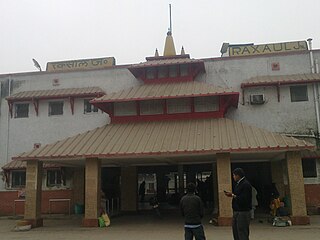
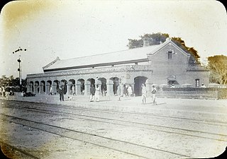
Raxaul is a sub-divisional town in the East Champaran district of the Indian state of Bihar. It is situated at the India-Nepal border with Birgunj city (Nepal). Raxaul is a major railway junction.
Khadda is a town, a Nagar panchayat and a Tehsil in Kushinagar district in the Indian state of Uttar Pradesh. It is situated approximately 8 km from the border of Bihar and 18 km from the India-Nepal border.

Sugauli is a city and a notified area in East Champaran district in the Indian state of Bihar. It is the setting for Rudyard Kipling's story "Rikki-Tikki-Tavi", and the place where a treaty was signed with Nepal in 1816.
Triyuga is one of eight municipalities of Udayapur district of the Koshi Pradesh of Nepal. Gaighat is the headquarter of the municipality. According to the 1991 Nepal census, it had a population of 55,291. According to the 2011 Nepal census, Triyuga had 87,557 inhabitants. According to the 2021 Nepal census the initial population of the municipality is 104,375. It is divided into 16 wards. Triyuga Municipality was established on B.S. Chaitra 13, 2053. It was named after Triyuga River. A river which flows through the town. Triyuga is the 3rd largest municipality in Nepal and 1st largest in Koshi Pradesh in term of size (area). The total area of the municipality is 547.43 square kilometres (211.36 sq mi)
Basatpur is a town and was Village Development Committee in Bara District in the Narayani Zone of south-eastern Nepal. According to new geographical updates in Nepal, Basatpur now falls under Kalaiya Sub-Metropolitan City and has been defined as Kalaiya-20 where 20 is a ward number in Kalaiya. It is now Basatpur in Bara District, Kalaiya Sub-Metropolitan City, Province Number 2, NEPAL. It's no longer Village Development Committee. The capital of the district is Kalaiya which is around 10 km north of Basatpur, Matiarwa lies west of Basatpur which is another town in the Kalaiya Sub-Metropolitan City. Adapur lies to the south of Basatpur which is a small town next to Basatpur in India. Basatpur is one of the biggest town and populated town in Kalaiya, Bara. To the south of Basatpur, it has open border of India which is just 1-2 km far from the town. It has plain areas and very fertile lands to grow crops. It is a popular town in the neighboring areas which is famous for its markets, ponds, temples, and culture. The majority of person living in the town are Hinduism and then Muslims. At the time of the 1991 Nepal census it had a population of 4,435 persons residing in 740 individual households.
Benauli is a town and Village Development Committee in Bara District in the Narayani Zone of south-eastern Nepal. At the time of the 1991 Nepal census it had a population of 5110 persons living in 659 individual households.
Pakadiya Chikani is a village (Ward) Ward No 6 of Pachrauta Municipality and in Bara District, in the Narayani Zone of south-eastern Nepal. At the time of the 2011 Nepal census it had a population of 5013 persons living in 672 individual households.
Auraiya was a village development committee in Rautahat District in the Narayani Zone of south-eastern Nepal. Now after formation of local government, Auraiya is in Ishnath Municipality. Auraiya is 6 km west of the district headquarters Gaur. The village takes its name from "Amla" which means "Indian gooseberry". At the time of the 2014 Nepal census it had a population of 10,832, in more than 1648 households. The literacy rate is 77%, which is higher than average in Nepal. Most of the people of the village are employed in the "government services" of Nepal like engineering, forestry, medicine, and education.
Gamhariya was a village development committee in Rautahat District in the Narayani Zone of south-eastern Nepal.
Gadhimai is a municipality in Rautahat district of Narayani zone, Nepal. It lies at the border of Rautahat district that links Sarlahi District over Bagmati River. It was formed by merging former 6 Village development committees Gamhariya, samanpur, Sangrampur, Bahuwa Madanpur, Dharampur and Bariyarpur just before 2017 Nepalese local elections.
Pacharauta is a municipality in Bara District in Province No. 2 of South-Eastern Nepal. It was formed in 2016 occupying current 9 sections (wards) from previous 9 former VDCs. It occupies an area of 44.01 km2 with a total population of 34,175.
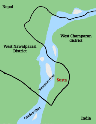
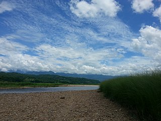
Susta is a disputed territory between Nepal and India. It is administered by India as part of West Champaran district of Bihar. It is claimed by Nepal as part of Susta rural municipality, under West Nawalparasi District in Lumbini Province. The disputed territory is located on the eastern side of the Gandak river. Nepal claims the area a part of West Nawalparasi District under Susta rural municipality, alleging that over 14,860 hectares of Nepali land in Susta has been encroached upon by India while India claims "Susta" to be a part of West Champaran district.
Khartari is a village in Chiraia Block, East Champaran District, Bihar, India. It is located near the border with Nepal, about 14 kilometres east of the district capital Motihari, and 3 kilometres southwest of the block capital Chiraia. In 2011, its population is 38,978.