Saint Helens is an unincorporated community in Lee County, Kentucky, in the United States. It lies along Route 52 east of the city of Beattyville, the county seat of Lee County. Its elevation is 728 feet (222 m). It has a post office with the ZIP code 41368. This post office preëmpted the naming of a community in Jefferson County as Saint Helens; instead, it had to adopt the name "Shively" after an early settler.
Zoe is an unincorporated community in Lee County, Kentucky, United States. It lies north of the city of Beattyville, the county seat of Lee County, along Route 11. Its elevation is 1,145 feet (349 m). It has a post office with the ZIP code 41397.

Saloma is an unincorporated community in Taylor County, Kentucky, United States. It lies along Routes 527 and 744 northwest of the city of Campbellsville, the county seat of Taylor County. Its elevation is 906 feet (276 m).
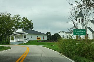
Kentontown is an unincorporated community in Robertson County, Kentucky, United States. It lies along U.S. Route 62 and Kentucky Route 617 southwest of the city of Mount Olivet, the county seat of Robertson County. Its elevation is 725 feet (221 m).
Gimlet is an unincorporated community in Elliott County, Kentucky, United States. It lies along Route 504 north of the city of Sandy Hook, the county seat of Elliott County. Its elevation is 1,102 feet (336 m).
Falcon is an unincorporated community in Magoffin County, Kentucky, United States. It lies along Route 40 northeast of the city of Salyersville, the county seat of Magoffin County. Its elevation is 974 feet (297 m). It has a post office with the ZIP code 41426.
Ivyton is an unincorporated community in Magoffin County, Kentucky, United States. It lies along Route 114 southeast of the city of Salyersville, the county seat of Magoffin County. Its elevation is 984 feet (300 m).
Hendricks is an unincorporated community in Magoffin County, Kentucky, United States. It lies along Route 30 south of the city of Salyersville, the county seat of Magoffin County. Its elevation is 876 feet (267 m).
Sublett is an unincorporated community in Magoffin County, Kentucky, United States. It lies along Route 7 southeast of the city of Salyersville, the county seat of Magoffin County. Its elevation is 883 feet (269 m).
Swampton is an unincorporated community in Magoffin County, Kentucky, United States. It lies along Route 7 southeast of the city of Salyersville, the county seat of Magoffin County. Its elevation is 919 feet (280 m).
Wheelersburg is an unincorporated community in Magoffin County, Kentucky, United States. It lies along Route 1081 northeast of the city of Salyersville, the county seat of Magoffin County. Its elevation is 853 feet (260 m).
Wonnie is an unincorporated community in Magoffin County, Kentucky, United States. It lies along U.S. Route 460 and Kentucky Route 1081 northwest of the city of Salyersville, the county seat of Magoffin County. Its elevation is 814 feet (248 m).
Caney is an unincorporated community and coal town in Morgan County, Kentucky, United States. It lies along Route 191 south of the city of West Liberty, the county seat of Morgan County. Its elevation is 869 feet (265 m).
Cottle is an unincorporated community in Morgan County, Kentucky, United States. It lies along U.S. Route 460 southeast of the city of West Liberty, the county seat of Morgan County. Its elevation is 801 feet (244 m).
Crockett is an unincorporated community in Morgan County, Kentucky, United States. It lies along Route 172 northeast of the city of West Liberty, the county seat of Morgan County. Its elevation is 912 feet (278 m). It has a post office with the ZIP code 41413.
Grassy Creek is an unincorporated community in Morgan County, Kentucky, United States. It lies along U.S. Route 460, southwest of the city of West Liberty, the county seat of Morgan County. Its elevation is 787 feet (240 m).
Lenox is an unincorporated community and coal town in Morgan County, Kentucky, United States. It lies along Route 172, northeast of the city of West Liberty, the county seat of Morgan County. Its elevation is 797 feet (243 m).
Mize is an unincorporated community in Morgan County, Kentucky, United States. It lies along U.S. Route 460 and Kentucky Route 203, southwest of the city of West Liberty, the county seat of Morgan County. Its elevation is 817 feet (249 m). It has a post office with the ZIP code 41352.
Malone is an unincorporated community in Morgan County, Kentucky, United States. It lies along Route 191 south of the city of West Liberty, the county seat of Morgan County. Its elevation is 797 feet (242 m). It has a post office with the ZIP code 41451.
White Oak is an unincorporated community in Morgan County, Kentucky, United States. It lies along U.S. Route 460 southeast of the city of West Liberty, the county seat of Morgan County. Its elevation is 801 feet (244 m).


