
The Pit River is a major river draining from northeastern California into the state's Central Valley. The Pit, the Klamath and the Columbia are the only three rivers in the U.S. that cross the Cascade Range.

Cushman Dam No. 2 is a hydroelectric dam on the North Fork of the Skokomish River in Mason County, Washington, United States, forming Lake Kokanee. Built in 1930, its three 27,000 kilowatt generators provide 233 million kilowatt-hours annually to the Tacoma Power system. Along with Cushman Dam No. 1, it is part of Tacoma Power's Cushman Project.

Oroville Dam is an earthfill embankment dam on the Feather River east of the city of Oroville, California, in the Sierra Nevada foothills east of the Sacramento Valley. At 770 feet (235 m) high, it is the tallest dam in the U.S. and serves mainly for water supply, hydroelectricity generation, and flood control. The dam impounds Lake Oroville, the second-largest reservoir in California, capable of storing more than 3.5 million acre-feet (1.1×10^12 US gal; 4.3×10⁹ m3).

New Bullards Bar Dam is a variable radius concrete arch dam constructed in the early 1960s in California on the North Yuba River. Located near the town of Dobbins in Yuba County, the dam forms the New Bullards Bar Reservoir, which can hold about 969,600 acre⋅ft (1.1960×10⁹ m3) of water. The dam serves for irrigation, drinking water and hydroelectric power generation.

Pine Flat Dam is a concrete gravity dam on the Kings River in the Central Valley of Fresno County, California United States. Situated about 28 miles (45 km) east of Fresno, the dam is 440 feet (130 m) high and impounds Pine Flat Lake, in the foothills of the Sierra Nevada just outside the boundary of Kings Canyon National Park. The dam's primary purpose is flood control, with irrigation, hydroelectric power generation and recreation secondary in importance.

Trinity Dam is an earthfill dam on the Trinity River located about 7 miles (11 km) northeast of Weaverville, California in the United States. The dam was completed in the early 1960s as part of the federal Central Valley Project to provide irrigation water to the arid San Joaquin Valley.
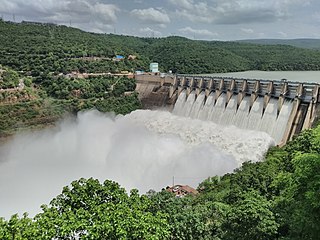
The Srisailam Dam is constructed across the Krishna River in Nandyal district, Andhra Pradesh and Nagarkurnool district, Telangana near Srisailam temple town and is the 2nd largest capacity working hydroelectric station in India.

Mammoth Pool Dam is a hydroelectric dam located on the San Joaquin River in the southern Sierra Nevada mountain range of California, about 45 miles (72 km) northeast of Fresno. It forms Mammoth Pool Reservoir and lies within the Sierra National Forest. The dam and reservoir were named after a large natural pool in the river that was once located above the present dam site.

New Exchequer Dam is a concrete–faced, rock-fill dam on the Merced River in central California in the United States. It forms Lake McClure, which impounds the river for irrigation and hydroelectric power production and has a capacity of more than 1,000,000 acre-feet (1.2 km3). The Merced Irrigation District (MID) operates the dam and was also responsible for its construction.

New Don Pedro Dam, often known simply as Don Pedro Dam, is an earthen embankment dam across the Tuolumne River, about 2 miles (3.2 km) northeast of La Grange, in Tuolumne County, California. The dam was completed in 1971, after four years of construction, to replace the 1924 concrete-arch Don Pedro Dam.

Pit-3 Dam is a hydroelectric dam on the Pit River in northern California in the United States. It forms Lake Britton, and is owned by the Pacific Gas and Electric Company (PG&E).

Castaic Power Plant, also known as the Castaic Pumped-Storage Plant, is a seven unit pumped-storage hydroelectric plant, operated by the Los Angeles Department of Water and Power, which provides peak load power from the falling water on the West Branch of the California State Aqueduct. It is a cooperative venture between the LADWP and the Department of Water Resources of the State of California. An agreement between the two organizations was signed on September 2, 1966, for construction of the project.

Pit 7 Dam is a run-of-the-river hydroelectric dam across the Pit River in northern California. Located just upstream of Shasta Lake, it is a concrete arch-gravity structure and its powerhouse has a capacity of 110 megawatts (150,000 hp). The dam is owned by the Pacific Gas and Electric Company.
Lake Spaulding Dam is a dam in Nevada County, California.

The Big Creek Hydroelectric Project is an extensive hydroelectric power scheme on the upper San Joaquin River system, in the Sierra Nevada of central California. The project is owned and operated by Southern California Edison (SCE). The use and reuse of the waters of the San Joaquin River, its South Fork, and the namesake of the project, Big Creek – over a vertical drop of 6,200 ft (1,900 m) – have over the years inspired a nickname, "The Hardest Working Water in the World".
Wishon Dam is a dam in Fresno County, California in the Sierra National Forest, in the Sierra Nevada Mountain Range. It impounds the North Fork Kings River to form Wishon Reservoir.
Donnells Dam is a concrete arch dam located on the Middle Fork of the Stanislaus River in Tuolumne County, California. The water impounded by the 291-foot (89 m) high dam forms Donnell Lake in Stanislaus National Forest. The dam and reservoir are co-owned by the Oakdale Irrigation District and South San Joaquin Irrigation District, and the dam is one of three in the Tri-Dam Project. The other two dams in the project are Beardsley Dam and Tulloch Dam.
Moccasin Dam is a small dam on Moccasin Creek in Tuolumne County, California, in the town of Moccasin, west of Yosemite. It holds the Moccasin Reservoir. The dam, reservoir and associated hydroelectric power plant are part of the Hetch Hetchy Project, which provide water and power to the city of San Francisco. The dam is located near the junction of Highway 120 and Highway 49.
Pit 5 Dam is a run-of-the-river hydroelectric dam on the Pit River in Shasta County, northeastern California, about 2 miles (3.2 km) south of Big Bend. It is part of the Pit 3-4-5 hydroelectric project owned by Pacific Gas & Electric Company.
