
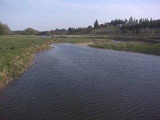
The Avon River is a river in Perth County, Ontario, Canada. The river was named after the River Avon in England when the town of Stratford was founded on its banks in 1832. The Avon River rises northeast of Stratford and flows southwest, entering the North Thames River near St. Marys. It was originally known as the Little Thames River.

Woodstock is a city in Southwestern Ontario, Canada. The city has a population of 40,902 according to the 2016 Canadian census. Woodstock is the seat of Oxford County, at the head of the non-navigable Thames River, approximately 128 km from Toronto, and 43 km from London, Ontario. The city is known as the Dairy Capital of Canada and promotes itself as "The Friendly City".
The Upper Thames River Conservation Authority is a body based in London, Ontario, Canada. It was created in 1947. It was responsible for the construction of the Fanshawe Dam, completed in the 1950s, to control flooding from the Thames River, which runs through London. During the last ice age, the site of London was the terminus of a large glacier. When the region warmed at the end of the ice age, the glacier melted and receded North, leaving behind a drainage ditch and features such as Sifton Bog. As such, the Thames is a watershed for most of Western Ontario, and is therefore highly susceptible to seasonal flooding. In 1937, such flooding had devastating consequences, destroying over 1,000 homes, and causing millions of dollars in damage.

Hugh Keenleyside Dam is a flood control dam spanning the Columbia River, 12 km upstream of the city of Castlegar, British Columbia, Canada.

Norris Dam is a hydroelectric and flood control structure located on the Clinch River in Anderson County and Campbell County, Tennessee, United States. The dam was the first major project for the Tennessee Valley Authority, which had been created in 1933 to bring economic development to the region and control the rampant flooding that had long plagued the Tennessee Valley. The dam was named in honor of Nebraska Senator George Norris (1861–1944), a longtime supporter of government-owned utilities in general, and supporter of TVA in particular. The infrastructure project was listed on the National Register of Historic Places in 2016.

The Salmon River is a small river north of Syracuse in Upstate New York, the United States. It is a popular and economically important sportfishing destination, and the most heavily fished of New York's Lake Ontario tributaries. From its headwaters in the Tug Hill region of New York, it flows 44 miles (71 km) westward through two hydroelectric dams and over the 110-foot (34 m) Salmon River Falls before it empties into eastern Lake Ontario at Port Ontario in Oswego County. The Salmon River watershed drains approximately 280 square miles (730 km2).
The Columbia River Treaty is a 1961 agreement between Canada and the United States on the development and operation of dams in the upper Columbia River basin for power and flood control benefits in both countries. Four dams were constructed under this treaty: three in the Canadian province of British Columbia and one in the U.S. state of Montana.

A reservoir is most commonly an enlarged natural or artificial lake created using a dam to store fresh water.

Canyon Lake is a reservoir on the Guadalupe River in the Texas Hill Country in the United States. Canyon Lake is a U.S. Army Corps of Engineers reservoir formed on the Guadalupe River in Comal County by Canyon Dam, which is located about sixteen miles northwest of New Braunfels. The dam, lake, and all adjacent property are managed by the U.S. Army Corps Of Engineers. Water rights, waste water treatment, and hydroelectric generating facilities are managed by the Guadalupe-Blanco River Authority. Construction of the dam began in 1958 and was completed in 1964. The reservoir serves to provide flood control and water supply for the communities downstream from the dam. The lake is also a popular recreational destination.
The Thames River is located in southwestern Ontario, Canada.
The Ware River is a 35.4-mile-long (57.0 km) river in central Massachusetts. It has two forks, both of which begin in Hubbardston, Massachusetts. The Ware River flows southwest through the middle of the state, joins the Quaboag River at Three Rivers, Massachusetts, to form the Chicopee River on its way to the Connecticut River.

The Lake Simcoe Region Conservation Authority is a conservation authority established in 1951, and is among the oldest in the Canadian province of Ontario.
Fanshawe Dam is a dam located on North Thames River near the eastern edge of London, Ontario. The crest of the dam is 625 metres long. It is 30.5 metres in height and drops the river surface 12 metres. Fanshawe Lake is the reservoir created by the dam. The hydroelectric generator of the Fanshawe Dam generates enough power to run 400 households. It is one of three dams on the Thames River and its tributaries.
Watauga Dam is a hydroelectric and flood control dam on the Watauga River in Carter County, in the U.S. state of Tennessee. It is owned and operated by the Tennessee Valley Authority, which built the dam in the 1940s as part of efforts to control flooding in the Tennessee River watershed. At 318 feet (97 m), Watauga is the second-highest dam in the TVA river and reservoir system, and at the time of its completion was one of the highest earth-and-rock dams in the United States. The dam impounds the TVA Watauga Reservoir of 6,430 acres (2,600 ha), and its tailwaters feed into Wilbur Lake. The Appalachian Trail crosses the top of Watauga Dam.
Wildwood Dam is a dam located on Trout Creek in Perth South, Ontario, which flows into the North Thames River in the Town of St. Marys. Wildwood Dam is designed for flood control and flow augmentation purposes.

Crooks' Hollow Dam was a buttressed gravity dam, built of concrete in 1916 on Spencer Creek in Greensville, Ontario, Canada. About 100 yards upstream from the ruins of the much earlier Cockburn sawmill and dam, it replaced that dam in supplying water by pipe to Dundas for all uses. It also provided much greater flood control, and, more than the Cockburn dam, supplied a managed flow for water power users in the industries downstream. The Dundas Star commented on its completion: "... an excellent piece of work. It is now hoped there will be no further difficulty about securing an adequate water supply for many years to come." The dam was demolished in early 2013.

The Moses-Saunders Power Dam, short for Robert Moses-Robert H. Saunders Power Dam, is a dam on the Saint Lawrence River straddling the border between the United States and Canada. It is located between Massena in New York and Cornwall in Ontario. The dam supplies water to two adjacent hydroelectric power generating stations, the United States' 912 MW St. Lawrence-Franklin D. Roosevelt Power Project and Canada's 1,045 MW R.H. Saunders Generating Station. Constructed between 1954 and 1958 as part of the larger Saint Lawrence Seaway project, the dam created Lake St. Lawrence. Aside from providing significant amounts of renewable power, the dam regulates the St. Lawrence River and affords passage for the navigation of large vessels. Despite the enormous economic advantages to the dam, it required the relocation of 6,500 people and caused harm to the surrounding environment. Efforts have been made over the years to improve shoreline and fish habitats.
Gordon William Pittock was a Canadian politician, who represented Oxford in the Legislative Assembly of Ontario from 1963 to 1967 as a Progressive Conservative member.

Conestogo Lake is a Artificial lake on the Conestogo River in Wellington County in Southwestern Ontario, Canada. It is a reservoir with a flood control dam.

